

Engineering-Led 3D LiDAR Scanning, Heritage Building Surveys, Scan-to-CAD & Restoration Documentation
Melbourne has a rich architectural history, with heritage-listed buildings, Victorian-era commercial properties, historic warehouses, industrial structures and significant public buildings forming an important part of the city’s built environment.
Preserving and adapting these buildings requires accurate documentation of existing conditions, particularly where original construction drawings are incomplete, outdated or unavailable.
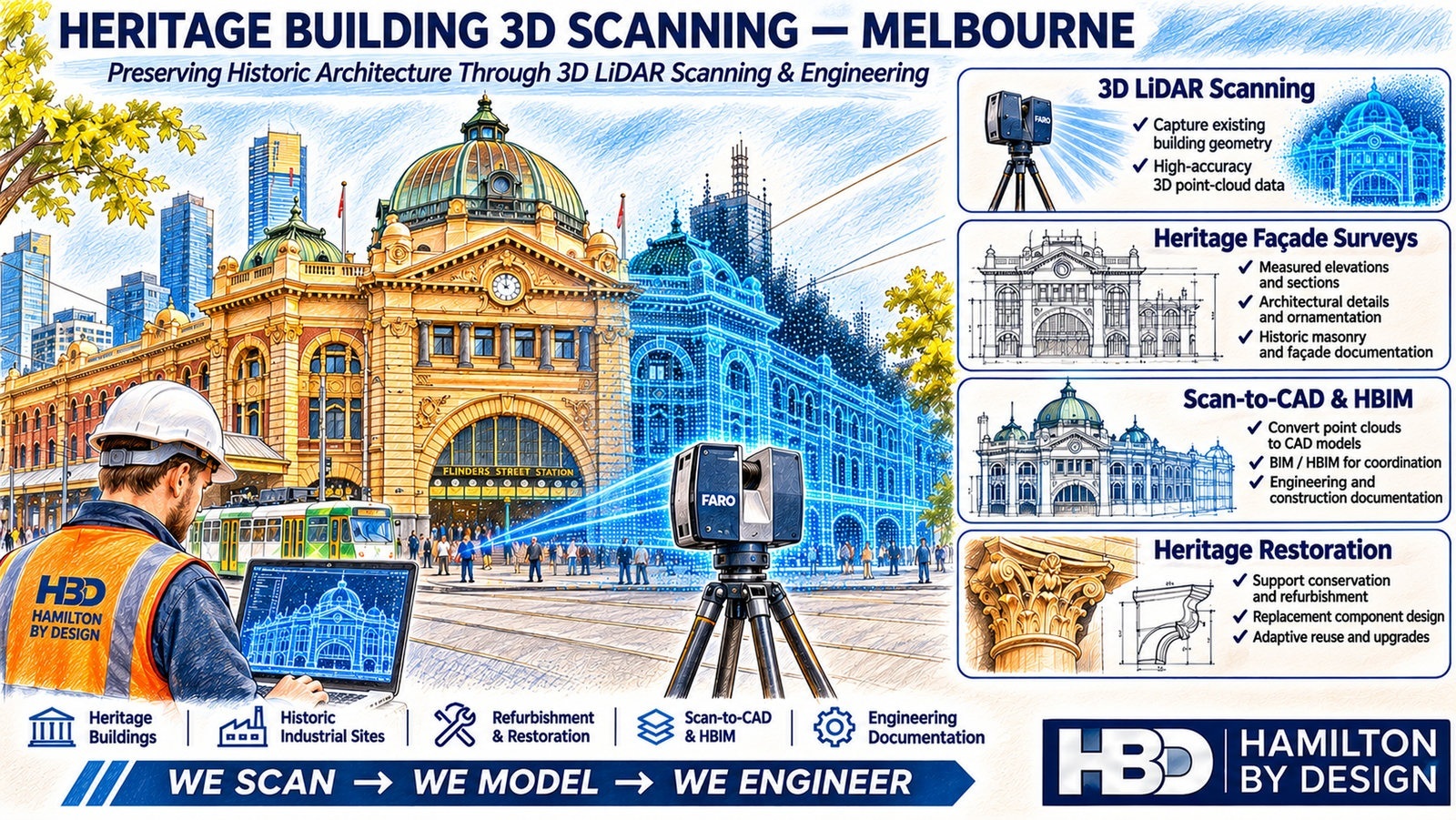
Hamilton By Design provides engineering-led heritage building 3D scanning services throughout Melbourne and Victoria, combining terrestrial LiDAR scanning, point-cloud processing, CAD modelling and engineering documentation to support heritage conservation, restoration, refurbishment and adaptive reuse projects.
Our approach connects physical site measurements with practical engineering and design deliverables.
We Scan → We Model → We Engineer.
Why Use 3D LiDAR Scanning for Heritage Buildings?
Heritage buildings often contain complex architectural details, irregular geometry, historic construction methods and alterations undertaken over many decades.
Traditional measurement methods can be time-consuming, particularly when documenting large façades, decorative architectural features, roof structures and areas with restricted access.
3D LiDAR scanning captures millions of spatial measurements to create a detailed three-dimensional point cloud representing visible building surfaces.
This digital record can support:
- Existing-condition documentation of heritage buildings.
- Measured façade elevations and architectural drawings.
- Restoration and conservation planning.
- Scan-to-CAD and Heritage Building Information Modelling (HBIM).
- Building refurbishment and adaptive reuse.
- Engineering design and construction coordination.
- Baseline geometric records before construction activities.
- Documentation of historic industrial structures.
By capturing building geometry before design work begins, project teams can reduce uncertainty associated with incomplete or inaccurate existing drawings.
Heritage Façade 3D Scanning Melbourne
Melbourne’s historic architecture includes elaborate Victorian façades, sandstone and bluestone construction, decorative masonry, arched windows, parapets, cornices and intricate architectural detailing.
These features can be difficult to document accurately using conventional measurement techniques.
Hamilton By Design uses terrestrial 3D laser scanning to capture the geometry of visible building surfaces and architectural features.
Point-cloud data can subsequently be used to prepare measured drawings and engineering models.
Typical applications include:
- Historic masonry and bluestone façades.
- Decorative architectural elements.
- Building elevations and external geometry.
- Window and door opening locations.
- Parapets, rooflines and cornices.
- Existing structural interfaces.
- Restoration and replacement component measurements.
Where detailed documentation is required, additional scanning positions or close-range measurement techniques may be used to capture complex architectural features.
Heritage Building Condition Surveys and Existing-Condition Documentation
Accurate existing-condition records are important when planning work on heritage buildings.
Many older structures have undergone extensions, repairs, modifications and changes in use, resulting in discrepancies between historical drawings and current conditions.
Hamilton By Design provides geometric survey information to support heritage consultants, engineers and architects undertaking building assessments.
Our scanning services can assist with:
- Recording existing building geometry.
- Identifying dimensional irregularities.
- Documenting accessible structural elements.
- Establishing baseline geometric records.
- Comparing repeat surveys where appropriate survey control is established.
- Supporting refurbishment design and engineering investigations.
Important: LiDAR scanning records geometry. Structural condition assessments, material deterioration investigations and movement monitoring require appropriately scoped engineering assessment, survey control and measurement verification.
Heritage Scan-to-CAD and HBIM Melbourne
Capturing a point cloud is often the first stage of a broader documentation process.
Hamilton By Design can develop CAD geometry and engineering models using registered 3D scan data.
Depending on project requirements, deliverables may include:
- 2D measured plans and elevations.
- Building sections and architectural details.
- 3D CAD models.
- Existing structural geometry.
- Simplified building models.
- Engineering drawings.
- Digital geometry for coordination with architectural and BIM workflows.
The required level of detail is established during project scoping, allowing the modelling effort to focus on the information needed for restoration, design or construction.
For heritage projects, a simplified geometric model may be sufficient for refurbishment coordination, while decorative elements may require more detailed modelling or specialist documentation.
3D Scanning for Heritage Restoration and Conservation
Heritage restoration projects frequently require replacement components to be designed around existing structures that may no longer be perfectly straight, level or symmetrical.
This is particularly relevant when restoring architectural features or installing new structural and mechanical systems within older buildings.
Hamilton By Design’s scanning and engineering services can support:
- Restoration of architectural elements.
- Replacement of deteriorated building components.
- Engineering interfaces between new and existing structures.
- Fabrication of replacement steelwork.
- Installation of services within constrained spaces.
- Dimensional verification before manufacturing.
- Development of CAD models for restoration works.
Our engineering-led approach allows captured site geometry to be incorporated into practical design and fabrication documentation.
Adaptive Reuse of Melbourne Heritage Buildings
Melbourne has many historic warehouses, factories, commercial buildings and industrial facilities that have been converted into offices, residential developments, hospitality venues and mixed-use spaces.
Adaptive reuse projects often involve integrating new building services and structural elements into existing structures.
3D scanning provides a digital representation of the building before design work begins.
Typical applications include:
- Historic warehouse conversions.
- Industrial building refurbishments.
- Commercial fit-outs.
- Building services upgrades.
- Structural alterations and extensions.
- Mechanical plant installations.
- New access platforms and steelwork.
- Coordination of existing and proposed building elements.
Hamilton By Design can assist with both scanning and subsequent engineering design, helping reduce the separation between site measurement and technical documentation.
Industrial Heritage 3D Scanning Victoria
Victoria’s industrial heritage includes historic manufacturing facilities, railway infrastructure, pumping stations, workshops, warehouses and industrial machinery.
These facilities can contain complex arrangements of steelwork, pipework, mechanical equipment and building structures.
Hamilton By Design’s mechanical engineering background is particularly relevant to industrial heritage projects requiring documentation of both buildings and machinery.
Applications include:
- Historic factories and workshops.
- Railway workshops and maintenance facilities.
- Pumping stations and water infrastructure.
- Industrial pipework and equipment.
- Structural steelwork and platforms.
- Machinery and mechanical components.
- Industrial building refurbishment.
- Engineering reverse-engineering projects.
Our combined scanning and CAD capabilities can support both heritage documentation and practical engineering modifications.
Our 3D Scanning Equipment
FARO Focus S70 Terrestrial Laser Scanner
Hamilton By Design uses the FARO Focus S70 terrestrial laser scanner for capturing building geometry, façades, structural elements and industrial facilities.
The scanner collects dense spatial measurements from multiple positions, allowing registered point clouds to be developed for subsequent CAD and engineering work.
Revopoint MetroY Ultra
For smaller components requiring detailed close-range geometry, Hamilton By Design also uses the Revopoint MetroY Ultra handheld 3D scanner.
This equipment can assist with reverse engineering and detailed component modelling where suitable access, surface conditions and measurement verification are available.
The scanning methodology is selected according to the required deliverables, site conditions, access limitations and project accuracy requirements.
Heritage 3D Scanning Deliverables
Depending on the agreed project scope, Hamilton By Design can provide:
| Deliverable | Typical Application |
|---|---|
| E57 Point Cloud | Registered 3D scan data |
| RCP / RCS | Autodesk ReCap-compatible point clouds |
| LAS | Point-cloud data exchange |
| DWG / DXF | Measured drawings and CAD geometry |
| STEP / Parasolid | Engineering CAD model exchange |
| PDF Drawings | Building elevations, sections and details |
| 3D CAD Models | Refurbishment and engineering design |
| Simplified BIM Geometry | Building coordination and digital documentation |
Deliverable formats, modelling detail and verification requirements are confirmed before commencement.
Our Heritage Building 3D Scanning Process
Step 1 — Project Review
We review the building location, available drawings, heritage constraints, required documentation and intended use of the scan data.
Step 2 — Scanning Methodology
A scanning approach is developed considering building size, access requirements, visibility, public areas, working hours and required detail.
Step 3 — Site 3D LiDAR Scanning
Multiple scanning positions are used to capture accessible building geometry and minimise occlusions.
For busy commercial areas, scanning outside normal operating hours may be considered to reduce interference from pedestrian and vehicle movements.
Step 4 — Point-Cloud Registration
Individual scans are registered into a coordinated point-cloud dataset.
Registration quality is reviewed before data is prepared for delivery or modelling.
Step 5 — CAD Modelling and Engineering Documentation
Where required, registered point clouds are used to develop measured drawings, CAD geometry and engineering documentation.
Step 6 — Project Delivery
Agreed deliverables are supplied in formats suitable for the client’s architectural, engineering or construction workflows.
Heritage Building 3D Scanning Across Melbourne and Victoria
Hamilton By Design provides project-based heritage 3D scanning services throughout metropolitan Melbourne and regional Victoria.
Areas of interest include:
- Melbourne CBD and the Hoddle Grid.
- Carlton and Fitzroy.
- Collingwood and Richmond.
- South Melbourne and Port Melbourne.
- Footscray and Yarraville.
- Williamstown.
- Brunswick and North Melbourne.
- St Kilda and surrounding suburbs.
- Geelong.
- Ballarat and Bendigo.
- Regional Victorian heritage and industrial sites.
Our services are suitable for individual heritage buildings, industrial facilities and larger multi-building documentation projects.
Why Choose Hamilton By Design?
Engineering-Led Scanning
Hamilton By Design combines 3D scanning with mechanical engineering and CAD design experience.
Scan-to-CAD Capability
We can convert captured geometry into practical CAD models and drawings, rather than providing point-cloud data alone.
Industrial and Building Experience
Our services extend across building structures, mechanical equipment, pipework, industrial facilities and construction projects.
Project-Specific Deliverables
Scanning and modelling are tailored to the intended use, avoiding unnecessary detail where a simpler engineering model is sufficient.
Quality Assurance
Point-cloud registration, modelling assumptions and dimensional requirements are considered as part of the project delivery process.
Frequently Asked Questions
Can 3D LiDAR scanning be used on heritage-listed buildings?
Yes. Terrestrial LiDAR scanning is a non-contact measurement technique suitable for documenting visible surfaces of heritage buildings, subject to site access and any relevant heritage requirements.
Can you produce CAD drawings from heritage building scans?
Yes. Hamilton By Design can prepare measured CAD drawings and 3D models from registered point-cloud data according to the agreed scope.
Can 3D scanning help with heritage restoration?
Yes. Accurate geometry can support restoration planning, replacement component design, refurbishment coordination and engineering documentation.
Can you scan large heritage façades?
Yes. Terrestrial scanning can document large façades using multiple scanner positions. Access, visibility, survey control and the required detail influence the methodology.
Can 3D scanning identify building movement?
Repeat scanning may support geometric comparisons, but reliable movement assessment requires suitable survey control, measurement uncertainty analysis and an appropriately designed monitoring methodology.
Do you provide services outside Melbourne?
Yes. Hamilton By Design undertakes project-based engineering and 3D scanning work across Australia, including regional Victoria.
Request a Heritage Building 3D Scanning Quote — Melbourne
Planning a heritage restoration, historic building refurbishment, façade survey or adaptive reuse project in Melbourne?
Hamilton By Design can assist with engineering-led 3D LiDAR scanning, point-cloud processing, measured drawings and CAD modelling.
To prepare a quotation, please provide the building location, available architectural drawings or photographs, approximate building dimensions, required deliverables and proposed project timeframe.
Hamilton By Design
Contact Us – Talk To Us
Our clients:

















We Scan → We Model → We Engineer
Contact Hamilton By Design to discuss your heritage building scanning requirements in Melbourne and Victoria.