


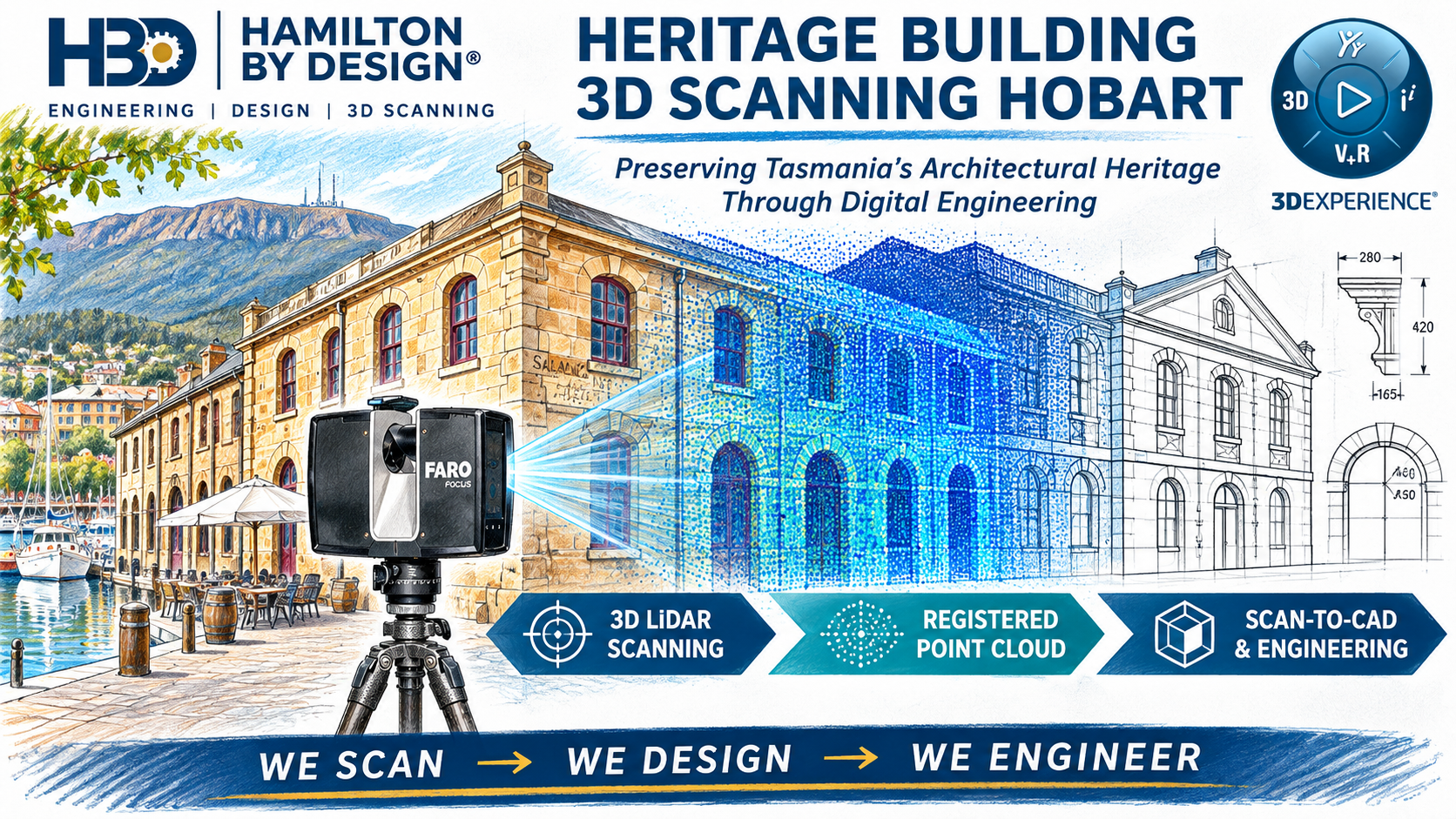
Professional 3D LiDAR Scanning for Heritage Buildings in Hobart, Tasmania
Hamilton By Design provides professional heritage building 3D scanning services in Hobart and throughout southern Tasmania, supporting architects, engineers, heritage consultants, restoration contractors and property owners with accurate digital documentation of existing structures.
Using engineering-grade terrestrial 3D LiDAR scanning technology, we capture detailed spatial information from historic buildings, including sandstone façades, masonry structures, architectural features, roof geometry, internal spaces and structural elements.
Hobart possesses a significant collection of Georgian, Victorian, colonial and industrial heritage buildings. Many of these structures incorporate traditional construction materials, irregular building geometry and architectural details that require careful documentation before restoration, refurbishment or modification.
Our integrated approach combines 3D LiDAR scanning, registered point cloud data, scan-to-CAD modelling and engineering expertise to establish reliable dimensional information for conservation planning and subsequent design activities.
We Scan → We Design → We Engineer
Why Use 3D LiDAR Scanning for Heritage Buildings in Hobart?
Heritage buildings frequently present measurement challenges that differ substantially from those encountered in contemporary construction.
Historic structures may contain irregular masonry, non-standard structural arrangements, undocumented alterations, uneven floors and complex architectural features. Original construction drawings may also be incomplete, inaccurate or unavailable.
Traditional measurement methods can be time-consuming and may not capture the spatial relationships between these elements adequately.
Terrestrial 3D LiDAR scanning addresses these limitations by recording millions of spatial measurements and developing a detailed three-dimensional representation of the building’s existing geometry.
Key applications include:
- Heritage building conservation and restoration planning.
- Existing-condition documentation before refurbishment.
- Historic façade and architectural feature measurement.
- Structural engineering investigations.
- Documentation of irregular masonry and building geometry.
- Adaptive reuse and building modification projects.
- Development of accurate architectural elevations and sections.
- Scan-to-CAD and digital building modelling.
- Fabrication of replacement architectural and structural components.
- Establishment of dimensional baseline records before construction activities.
The resulting point cloud provides a measurable digital reference that can be examined by architects, engineers and other project stakeholders.
Importantly, LiDAR scanning captures visible surface geometry without requiring extensive physical contact with potentially fragile heritage materials.
Heritage Façade 3D Scanning in Hobart
Hobart’s historic streetscapes contain numerous buildings constructed from sandstone, brickwork and traditional masonry.
These structures frequently incorporate decorative cornices, parapets, arched openings, stone columns, window surrounds and other architectural elements that can be difficult to document using conventional measurement techniques.
Hamilton By Design provides heritage façade scanning to capture the existing geometry of these features and support the development of accurate restoration and refurbishment documentation.
Typical façade scanning applications
Sandstone and masonry restoration
Detailed dimensional capture of existing stonework, masonry joints, architectural profiles and replacement component interfaces.
Historic window and door openings
Measurement of irregular openings and surrounding building geometry to assist with the design and fabrication of replacement elements.
Decorative architectural features
Documentation of cornices, arches, parapets, columns and other significant architectural details.
Façade refurbishment
Existing-condition capture to support repair planning, architectural drawings and coordination of proposed building modifications.
Structural assessment support
Provision of geometric information to assist structural engineers in evaluating existing arrangements and identifying dimensional irregularities.
Heritage condition documentation
Establishment of a digital geometric baseline that may assist subsequent inspections and comparisons where compatible survey methods and reference controls are employed.
Multiple scanning positions may be required to capture complex façades and reduce areas obscured from the scanner’s line of sight.
3D Scanning for Heritage Building Restoration
Restoration and conservation projects require a detailed understanding of existing building conditions before replacement components or structural modifications can be designed.
Historic buildings may have undergone decades of settlement, movement, weathering and alteration, resulting in geometry that differs from the original construction intent.
Reliance on nominal dimensions or incomplete historical drawings can introduce significant uncertainty during fabrication and installation.
Hamilton By Design uses registered LiDAR point cloud data to establish measured existing conditions and support subsequent engineering and CAD activities.
Heritage restoration applications include:
Historic sandstone buildings
Capture of existing masonry geometry, architectural profiles and dimensional interfaces for conservation and restoration planning.
Timber and steel structural elements
Documentation of accessible beams, columns, roof framing and structural connections to support engineering investigations and modification design.
Heritage roof structures
Measurement of accessible roof geometry, parapets, roof interfaces and supporting structural arrangements.
Architectural component replacement
Development of CAD geometry to support the manufacture of replacement components that interface with existing heritage structures.
Building refurbishment
Documentation of internal spaces, floor levels, wall geometry and structural arrangements before refurbishment works.
Adaptive reuse projects
Capture of existing building geometry to support the integration of new building services, access arrangements and structural modifications.
These services provide project teams with dimensional information that can reduce uncertainty during design development and construction coordination.
Scan-to-CAD Modelling for Heritage Buildings
Hamilton By Design provides more than terrestrial laser scanning.
As an engineering and design consultancy, we can convert registered point cloud information into CAD geometry and technical drawings suited to the requirements of architects, engineers, builders and fabrication contractors.
Our workflow integrates:
3D LiDAR Scanning → Point Cloud Registration → CAD Modelling → Engineering Design
Depending on the project scope, deliverables may include:
- Existing-condition architectural floor plans.
- Building elevations and cross-sections.
- Simplified three-dimensional building models.
- Existing structural arrangement drawings.
- Detailed component geometry.
- Fabrication and installation drawings.
- Engineering design models.
- CAD geometry for coordination with other consultants.
Working directly from registered scan data allows proposed designs to be assessed against measured building geometry.
This approach is particularly beneficial for heritage projects where existing conditions may differ significantly from conventional construction tolerances.
Heritage Building Point Cloud Deliverables
Following site scanning and point cloud registration, Hamilton By Design can provide digital information in formats compatible with commonly used architectural and engineering software.
| File Format | Typical Application |
|---|---|
| .E57 | Registered point cloud exchange between scanning and modelling platforms |
| .RCP / .RCS | Autodesk ReCap, AutoCAD and compatible design workflows |
| .LAS | Point cloud data exchange and spatial analysis |
| .DWG / .DXF | CAD drawings, elevations and sections |
| .STEP | Three-dimensional CAD geometry exchange |
| Architectural and engineering drawings |
The selection of deliverables depends on the intended use of the data, required level of detail and agreed project scope.
Where Revit or BIM models are required, the modelling methodology, geometric detail and information requirements should be established before commencement.
Engineering-Led Heritage Building Documentation
A distinguishing capability of Hamilton By Design is the integration of terrestrial LiDAR scanning with engineering design and CAD modelling.
Heritage restoration projects often require more than the collection of dimensional data.
Architects and engineers may need to understand how new structural elements, mechanical services or fabricated components will interface with an existing building.
Our engineering-led approach allows captured geometry to be used directly in the development of technical models and drawings.
This capability is particularly relevant to:
- Replacement steelwork and structural interfaces.
- Mechanical services modifications.
- Access platforms and building maintenance systems.
- Existing roof and support arrangements.
- Fabricated architectural components.
- Refurbishment and adaptive reuse projects.
- Dimensional verification before installation.
By combining scanning, modelling and engineering activities, Hamilton By Design provides a coordinated approach to existing-condition documentation and design development.
Where specialist heritage assessments, structural certification or statutory approvals are required, these are undertaken by appropriately qualified professionals within the relevant project scope.
Non-Contact Scanning of Sensitive Heritage Structures
Conservation work requires careful consideration of the physical condition and historical significance of existing building materials.
Terrestrial LiDAR scanning is a non-contact measurement technique, making it particularly suitable for documenting fragile masonry, deteriorated architectural elements and other sensitive surfaces.
Scanning can often be undertaken from accessible positions without the need to physically measure every architectural feature.
However, elevated access may be required where roof details, parapets or other features are obscured from ground-level scanning positions.
Our scanning methodology considers:
- Building accessibility and occupancy.
- Public and pedestrian movements.
- Heritage material sensitivity.
- Scanner line-of-sight limitations.
- Working at heights and elevated access requirements.
- Site safety and operational constraints.
- Environmental and weather conditions.
External scanning is scheduled around suitable weather conditions, as rainfall can affect the quality of LiDAR measurements.
Where appropriate, scanning can be coordinated outside normal operating hours to minimise disruption to building occupants and surrounding activities.
Heritage Building Scanning Across Hobart and Southern Tasmania
Hamilton By Design provides heritage building 3D scanning services for projects throughout Hobart and the surrounding region.
Service areas include:
- Hobart CBD.
- Battery Point.
- Salamanca Place and the waterfront.
- Sandy Bay.
- North Hobart.
- South Hobart.
- West Hobart.
- New Town.
- Moonah and Glenorchy.
- Bellerive and Rosny.
- Richmond.
- New Norfolk and the Derwent Valley.
- Kingston and the Kingborough region.
- Southern Tasmania.
Our services are suitable for individual heritage properties, historic commercial buildings, industrial heritage facilities and larger restoration or adaptive reuse projects.
Project scheduling and mobilisation arrangements are established according to site requirements, building accessibility and the proposed scanning scope.
Why Choose Hamilton By Design?
Engineering and CAD Expertise
Our engineering background allows us to understand how captured building geometry will be used in subsequent design, fabrication and construction activities.
Professional Terrestrial LiDAR Scanning
We use FARO Focus terrestrial laser scanning technology to capture detailed existing-condition geometry.
Integrated Scan-to-CAD Services
Registered point cloud data can be developed into CAD models, elevations, sections and technical drawings.
Flexible Digital Deliverables
We provide point cloud and CAD formats suited to architectural, engineering and construction workflows.
Heritage Restoration Support
Our services assist with the documentation of historic building features, structural interfaces and replacement components.
Australia-Wide Project Capability
Hamilton By Design provides professional scanning and engineering services for projects throughout Australia, including Hobart and regional Tasmania.
Request a Heritage Building 3D Scanning Quotation in Hobart
Planning the restoration, conservation, refurbishment or adaptive reuse of a heritage building in Hobart?
Hamilton By Design can assist with accurate existing-condition documentation, registered point cloud data and engineering-led CAD modelling.
Whether your project involves a historic sandstone façade, an industrial heritage building, architectural restoration or structural modification, we can discuss an appropriate scanning and documentation scope.
Contact Hamilton By Design to discuss your heritage building 3D scanning requirements.
Hamilton By Design
Contact Us – Talk To Us
Our clients:























Engineering-Grade 3D LiDAR Scanning | Scan-to-CAD | Mechanical Engineering
We Scan → We Design → We Engineer