Mechanical Engineering | 3D Scanning | 3D Modelling
Tag: Reality Capture
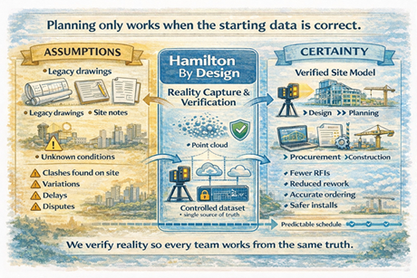
Reality capture services for accurately documenting existing conditions of buildings, plant, structures, and sites.
This tag covers engineering-led reality capture methods — including LiDAR scanning, point-cloud processing, and scan-to-CAD workflows — used to create reliable as-built documentation, 3D models, and design-ready data for mechanical, structural, and fabrication projects.
Reality Capture for Live Sites Sydney | 3D Scanning Without Shutdowns
Keep Sydney Projects Running: Accurate Reality Capture Without Shutdowns
Many projects across Greater Sydney and the Central Coast take place in live, operational environments — hospitals, shopping centres, CBD offices, industrial plants, transport facilities, and heritage buildings — where shutdowns are either impossible or extremely costly.
At Hamilton By Design, we provide engineer-led reality capture and 3D scanning services that allow accurate measurement, modelling, and verification without interrupting operations. Our approach supports safe access, staged construction, and clash-free installation — keeping your project moving while reducing risk, rework, and variations.
The Challenge of Working in Live Environments
Builders, project managers, and facilities teams face real risks when upgrading or modifying operational sites:
Buildings that have moved over time, with visible cracking or deformation
Changes in soil conditions or legacy engineering affecting structure and services
Outdated or unreliable drawings that no longer reflect site conditions
Unexpected clashes once walls, ceilings, or plant rooms are opened
High costs from rework and contract variations
Safety risks from confined spaces, working at heights, or restricted access zones
Relying on manual measurement or assumptions in these environments increases both programme risk and safety exposure.
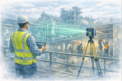
Non-Contact Measurement for High-Risk and Restricted Sites
Our reality capture solutions use non-contact laser scanning and LiDAR technology to safely collect accurate site data, even in difficult or restricted environments.
This allows us to capture:
Services above ceilings and within plant rooms
Structural elements and building geometry
Equipment clearances and access constraints
Deformed or out-of-plumb structures
All while minimising disruption to occupants and operations.
Safety and Access Benefits
Reduced need for working at heights
Faster site presence and data capture
Minimal interference with daily operations
Scanning possible from walkways or public-access areas
Fewer permits, isolations, and shutdown windows required
This makes scanning ideal for live hospitals, retail centres, offices, and industrial facilities where safety and continuity are critical.
Supporting Staged Construction and Live Upgrades
Live environments rarely allow full shutdowns. Our reality capture workflows are designed to support:
Staged construction programs
Progressive installation of services
Ongoing refurbishment works
Verification before each construction phase
We can also perform repeat scanning to monitor:
Structural movement
Progressive cracking
Deformation of walls, floors, or structural members
This is especially valuable where movement, settlement, or ageing infrastructure is a concern.
Practical Outcomes for Builders and Project Teams
Our scan data is not just collected — it is engineered into practical construction deliverables that support real project decisions.
Clients use our reality capture outputs for:
Design of new mechanical, electrical, and plumbing services
Accurate as-built verification prior to fabrication
Set-out and coordination models for installation
Clash detection before construction begins
Monitoring movement or deformation over time
This reduces uncertainty, improves coordination between trades, and significantly lowers the risk of costly on-site surprises.
Construction-Ready Deliverables
We provide data in formats that integrate directly into your existing workflows and design platforms:
Point clouds (RCP / E57)
Revit models
AutoCAD files
SolidWorks models
2D drawings (plans, sections, elevations)
Clash-ready coordination models
Our focus is on delivering usable, construction-ready information, not just raw scan files.
Engineer-Led Reality Capture — Not Just Scanning
Hamilton By Design is not a scanning-only provider. We deliver end-to-end technical services, allowing us to support projects from concept through to installation.
Our integrated capabilities include:
Reality capture and 3D scanning
Mechanical engineering
Systems management
Project management
Machining and fabrication support
Because our work is engineer-led, scan data is interpreted with constructability, tolerances, and installation constraints in mind — not simply converted into drawings by offshore drafting teams.
This means better decisions, fewer assumptions, and stronger outcomes on site.
Supporting Greater Sydney and the Central Coast
We regularly support projects across:
Sydney CBD and metropolitan areas
Major commercial and retail precincts
Health and education facilities
Industrial and processing plants
Infrastructure and heritage assets
Central Coast commercial and industrial sites
Our local presence allows efficient mobilisation and ongoing project support throughout staged works.
Reduce Risk. Avoid Shutdowns. Build With Confidence.
Reality capture is no longer just a documentation tool — it is a risk management strategy for live environments.
By capturing what is truly on site before construction begins, you can:
Prevent clashes and redesign
Reduce variations and rework
Improve safety planning
Protect programme and operational continuity
Arrange a Phone Consultation
If you are planning works in a live or high-risk environment and need reliable site data without shutdowns:
Please fill out the form below to arrange a phone consultation.
We’ll discuss your site conditions, construction staging, and deliverable requirements, and recommend the most effective reality capture approach for your project.
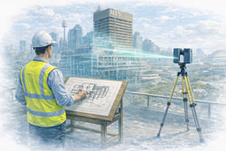
Engineering-Led 3D Laser Scanning Services in Sydney
3D scanning in Sydney is no longer just about capturing point clouds — it’s about delivering engineering-grade data that can be trusted for design, verification, fabrication, and construction.
At Hamilton By Design, we provide engineer-led 3D laser scanning and reality capture services across Sydney and NSW, supporting projects where accuracy, accountability, and buildability matter.
Our workflows combine LiDAR scanning, CAD modelling, and engineering judgement, ensuring scan data is not only precise — but fit-for-purpose.
Why Engineering-Grade 3D Scanning Matters
Not all 3D scanning is equal. Many projects fail not because scanning was done — but because it was done without engineering context.
We routinely see issues such as:
Scan data captured without understanding fabrication tolerances
Models built directly from point clouds without verification
Shutdown or site work impacted by poor fit-up
Drawings that look accurate but fail on site
Our approach closes that gap by ensuring scanning is owned by the engineer, not handed off without accountability.
Our 3D Scanning Capabilities in Sydney
We support a wide range of Sydney projects, including:
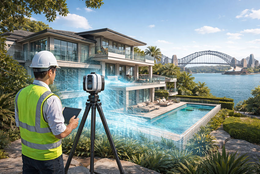
Reality Capture Sydney for Real Estate & Property Assets
High-Accuracy Digital Records and Premium Visual Context
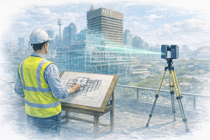
Sydney’s real estate and commercial property market demands accurate information, clear presentation, and confidence in decision-making. Whether supporting leasing, refurbishment, due diligence, or long-term asset management, reality capture in Sydney provides property owners and managers with a reliable digital record of what exists today.
Hamilton By Design delivers professional reality capture services in Sydney, combining high-accuracy spatial data with high-end visual outputs suited to commercial and premium property assets.
What Is Reality Capture for Real Estate?
In a property context, reality capture is the process of digitally recording buildings and spaces using advanced laser scanning and spatial capture technologies. The result is a dimensionally accurate digital representation of an asset that can be reused across multiple projects without repeated site visits.
Reality capture is commonly used across Sydney for:
Accurate existing-condition records
Leasing and tenancy planning
Commercial fit-outs and refurbishments
Asset documentation and compliance support
Due diligence during acquisition or divestment
Unlike traditional photography or basic floor plans, reality capture provides measurable, verifiable data that reduces uncertainty and risk.
High-End Capture of Sydney’s Harbour & Landmark Context
For premium assets, context matters. Hamilton By Design captures high-resolution reality capture imagery that includes Sydney’s built environment and surrounding landmark context, where appropriate.
This may include:
Harbour-front commercial buildings
Assets with views or proximity to Sydney Harbour
Visual context incorporating the Sydney Harbour Bridge
CBD and waterfront developments
These high-end visuals support investor presentations, leasing material, and executive-level decision-making, while remaining grounded in accurate spatial data.
Why Reality Capture Matters in Sydney’s Property Market
Sydney properties often involve:
High asset values
Live, occupied buildings
Tight refurbishment timeframes
Complex services and structural interfaces
Reality capture helps property stakeholders to:
✔ Verify what exists before committing capital ✔ Reduce surprises during refurbishments ✔ Support consultants with reliable base information ✔ Minimise disruption to tenants ✔ Maintain a long-term digital record of the asset
For property owners and managers, this translates directly to reduced risk and better outcomes.
Typical Real Estate Applications
As-Built Property Records
Create accurate digital records where original drawings are missing, outdated, or unreliable.
Leasing & Tenancy Planning
Support test fits, space planning, and consultant coordination with trusted spatial data.
Refurbishment & Upgrade Projects
Capture existing conditions prior to works to reduce redesign, delays, and cost overruns.
Due Diligence & Asset Review
Provide clarity and confidence during acquisition, divestment, or asset reviews.
A Professional, Asset-Focused Approach
While many services focus on visual outputs alone, Hamilton By Design approaches reality capture from an asset and decision-support perspective. Our deliverables are:
Dimensionally reliable
Fit for professional use
Suitable for consultants and contractors
Appropriate for commercial and executive audiences
This ensures reality capture data can be relied upon when property decisions carry financial and contractual significance.
Deliverables to Suit Property Clients
Depending on your requirements, we can provide:
Registered point clouds
CAD-ready base files
Accurate spatial references
Section views and area verification
Digital records suitable for future upgrades
All outputs are tailored to the intended property use, not generic scanning deliverables.
Our clients:
Reality Capture Sydney — Confidence for Property Decisions
Reality capture removes uncertainty from property decisions. By accurately capturing what exists today, Sydney property owners and managers can plan, lease, refurbish, and manage assets with confidence.
Hamilton By Design supports Sydney real estate and commercial property clients with professional reality capture services that combine accuracy, clarity, and premium presentation.
Contact Hamilton By Design to discuss your Sydney property or real estate reality capture requirements.
Traralgon sits at the centre of the Latrobe Valley — one of Australia’s most significant energy and industrial regions. For decades, the area supported large-scale power generation and heavy infrastructure. Today, Traralgon is at the frontline of energy transition, where legacy assets, decommissioning works, rehabilitation, and new infrastructure all coexist.
Engineering in this environment is rarely simple. Projects often involve ageing plant, undocumented modifications, strict safety requirements, and high public scrutiny. Getting the data right up front is critical.
Hamilton By Design supports Traralgon projects with engineering-led 3D LiDAR laser scanning, mechanical and structural engineering, 3D modelling, FEA, and easy-to-build fabrication drawings with engineering approval, helping asset owners and contractors reduce risk and move confidently from concept to construction.
Engineering in Traralgon: Legacy Assets and Future Infrastructure
Most engineering work in Traralgon is brownfield by default. Typical projects include:
Power station and energy-related infrastructure
Decommissioning and staged demolition works
Industrial plant upgrades and repurposing
Transmission, substations, and supporting structures
Many assets were designed to older standards and modified repeatedly over decades. Accurate as-built information, conservative engineering judgement, and clear documentation are essential to safely manage change.
3D Laser Scanning for Traralgon Sites
High-accuracy 3D LiDAR laser scanning provides the foundation for safe and efficient engineering in Traralgon.
Hamilton By Design captures precise as-built data for:
Large industrial plant and energy infrastructure
Structural steel, conveyors, platforms, and access ways
Decommissioning and rehabilitation sites
Assets with limited, outdated, or unreliable drawings
3D scanning records the true as-built condition — including deformation, misalignment, corrosion loss, and undocumented changes — without disrupting live operations.
FEA for Verification of Existing and Modified Assets
Traralgon engineering frequently involves verifying old assets under new conditions. Finite Element Analysis (FEA) plays a critical role in understanding real structural behaviour.
Hamilton By Design applies FEA to:
Assess structural capacity and load paths
Check deflection, fatigue, and buckling
Verify temporary and permanent works
Support strengthening, reuse, or staged demolition decisions
By analysing as-built geometry, FEA provides more reliable insight — essential when working with large, safety-critical infrastructure.
Easy-to-Build Fabrication Drawings with Engineering Approval
Clear, practical documentation is vital for Traralgon projects, where fabrication, installation, and demolition often occur in high-risk environments.
Hamilton By Design delivers easy-to-build fabrication and installation drawings, including:
General arrangement drawings
Fabrication and workshop details
Installation, lifting, and staging layouts
As-built documentation
Drawings are produced directly from scanned data and validated 3D models and can be issued with engineering approval, giving contractors confidence that what is built or modified will fit, function, and comply.
Hamilton By Design provides a single, engineering-led digital workflow — from site capture through to modelling, analysis, and construction documentation.
For Traralgon clients, this means:
Reduced risk on complex brownfield and transition sites
Better decision-making before shutdowns or demolition works
Designs grounded in real site conditions
Fabrication-ready drawings backed by engineering sign-off
Whether you’re modifying legacy energy infrastructure, planning decommissioning works, or developing the next generation of industrial assets, Hamilton By Design delivers accurate, practical, and build-ready engineering solutions tailored to Traralgon’s unique challenges.
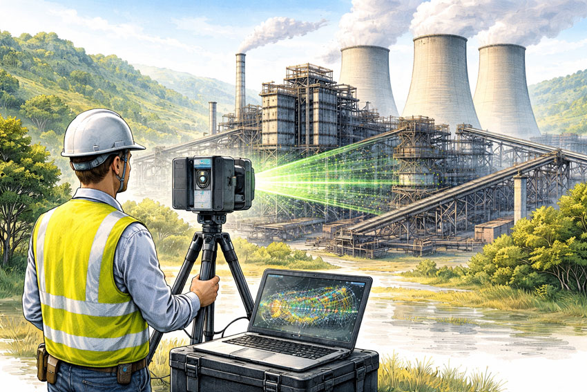
The Hunter Valley remains one of Australia’s most important industrial regions. With world-class mining operations, CHPP facilities, fabrication workshops, power generation assets and major industrial precincts, the region depends on precision, reliability and efficient project planning. As plants age and infrastructure expands, the challenge of capturing accurate site information becomes increasingly critical.
This is why laser scanning in the Hunter Valley has rapidly become a foundational tool for maintenance, engineering, redesign, shutdown preparation and fabrication accuracy. Organisations across the region are turning to laser scanning because the demands of modern industrial work simply cannot be met with traditional tape measurements or outdated drawings.
Hamilton By Design is proud to deliver engineering-grade laser scanning throughout the Hunter Valley, supporting safer worksites, faster project execution and significantly improved installation outcomes. Below, we explore why laser scanning is essential, how the technology works and how it transforms operations across the region.
Why Laser Scanning Has Become Essential in the Hunter Valley
Across the Hunter, very few sites resemble their original drawings. Over decades, plants evolve—structures deform, temporary fixes become permanent, equipment shifts, and countless undocumented modifications occur.
These realities create a major problem: Projects that rely on inaccurate measurements inevitably face delays, rework and installation challenges.
The consequences of bad data include:
Structural steel not fitting on site
Conveyor alignment issues
Misaligned chutes or transfer points
Inaccurate pipe spool lengths
Unexpected clashes in congested areas
Extended shutdown duration
Significant cost blowouts
By contrast, laser scanning in the Hunter Valley provides a millimetre-accurate digital representation of the real site, eliminating uncertainty and enabling confident engineering decisions.
How Laser Scanning Works
Laser scanning—also known as LiDAR (Light Detection and Ranging)—captures millions of precise data points across a site in seconds. These points create a “point cloud,” a detailed 3D representation of the scanned environment.
The Hamilton By Design workflow typically includes:
1. On-Site High-Accuracy Capture
We scan assets such as:
Structural frames
Conveyors, transfer towers and walkways
Chutes, bins, hoppers and material-handling systems
Tanks and pipe networks
Mechanical equipment
Buildings and platforms
Processing areas and plant rooms
Scanning is performed safely, quickly and with minimal disruption to operations.
2. Point Cloud Processing
Individual scans are aligned and merged into a single, unified as-built dataset.
3. CAD Modelling
From the point cloud, we create:
Accurate 3D models
General arrangement drawings
Fabrication details
DXF files for workshop use
Digital templates for pattern development
4. Engineering & Fabrication Support
We run digital checks for:
Clearances
Misalignments
Bolt pattern accuracy
Clash detection
Fit-up assurance
This ensures all new components, structures and mechanical systems integrate correctly the first time.
Industries in the Hunter Valley Using Laser Scanning
The Hunter Valley is one of Australia’s largest mining hubs, and laser scanning has become indispensable for:
Chute redesign and optimisation
Conveyor alignment and pulley checks
Structural replacements
Screening and crushing system upgrades
Transfer tower modifications
Bin and hopper geometry capture
Shutdown planning and scope definition
In CHPP environments—where dust, vibration, wear and deformation are constant—accurate as-built data is essential for safe and efficient upgrades.
2. Local Fabrication Workshops
Fabricators across Singleton, Muswellbrook, Rutherford and Thornton rely on precise digital information to ensure their products fit perfectly in the field. Laser scanning supports:
Steel replacement projects
Pipe spool fabrication
Custom chutes and transfer systems
Platform and walkway upgrades
Reverse engineering worn components
By basing fabrication on exact site geometry, rework and installation delays are dramatically reduced.
3. Power Stations and Energy Infrastructure
The Hunter Valley contains major energy assets requiring constant maintenance and upgrades. These aging facilities benefit greatly from laser scanning for:
Structural integrity assessments
Boiler house modifications
Pipe rerouting and replacements
Access platform upgrades
Plant room modelling
Compliance documentation
Laser scanning supports safe access, better planning and accurate engineering.
4. Industrial, Manufacturing and Infrastructure Projects
The region’s industrial footprint is expanding, and many facilities require precise as-built data for:
Renovations or expansions
Facility mapping
Mechanical upgrades
Brownfield redevelopment
BIM integration
Laser scanning provides the detail needed to plan these works correctly.
Digitally verified data ensures that fabrication is correct the first time.
3. Improved Safety
No need for workers to climb, stretch, or enter hazardous areas to measure.
4. Faster Shutdowns
Accurate pre-planning reduces onsite delays.
5. Digital Collaboration
Point clouds allow teams, contractors and engineers to review the site remotely.
6. Enhanced Engineering Confidence
Decisions are made on verified data, improving outcomes across the entire project lifecycle.
The Hamilton By Design Advantage
Hamilton By Design delivers more than just scanning—we combine decades of engineering, drafting and fabrication experience to interpret the data with real-world understanding.
What Sets Us Apart:
Engineering-Driven Approach
We understand the mechanical and structural context behind each scan.
Full Digital Workflow
From scan → point cloud → 3D model → fabrication drawings → installation, we support your entire project.
Local Knowledge of Hunter Valley Industry
We work routinely with mines, CHPPs, fabricators and industrial facilities across the region.
Fabrication-Ready Outputs
All models and drawings are created with workshop requirements and site constraints in mind.
Confidence Before Installation
We digitally confirm fitment before steel is cut—removing risk.
Applications Where Laser Scanning Delivers Immediate Value
Chute replacements
Conveyor system upgrades
Access platforms and walkways
Crusher and screen changes
Transfer tower redesign
Pipe spool fabrication
Structural steel alignment checks
Bin, tank and hopper measurement
Reverse engineering
Brownfield plant expansions
Anywhere accuracy matters, scanning is the superior choice.
Laser Scanning in the Hunter Valley: The New Standard
Across the region, laser scanning is now considered a must-have for safe, efficient and predictable project delivery. As plants age and the complexity of upgrades increases, organisations that invest in accurate data significantly outperform those relying on outdated drawings or manual measuring.
For engineering teams, maintenance planners, workshop fabricators and shutdown coordinators, laser scanning provides the certainty required to deliver work on time and on budget.
Partner with Hamilton By Design
When you choose Hamilton By Design for laser scanning in the Hunter Valley, you’re choosing:
Accuracy
Safety
Engineering reliability
Better planning
Reduced risk
Efficient installation
We’re ready to support your next shutdown, upgrade, redesign or fabrication project with the digital precision it deserves.
Contact Hamilton By Design today to discuss your site and discover how laser scanning can transform your project outcomes.
To provide the best experiences, we use technologies like cookies to store and/or access device information. Consenting to these technologies will allow us to process data such as browsing behaviour or unique IDs on this site. Not consenting or withdrawing consent, may adversely affect certain features and functions.
Functional
Always active
The technical storage or access is strictly necessary for the legitimate purpose of enabling the use of a specific service explicitly requested by the subscriber or user, or for the sole purpose of carrying out the transmission of a communication over an electronic communications network.
Preferences
The technical storage or access is necessary for the legitimate purpose of storing preferences that are not requested by the subscriber or user.
Statistics
The technical storage or access that is used exclusively for statistical purposes.The technical storage or access that is used exclusively for anonymous statistical purposes. Without a subpoena, voluntary compliance on the part of your Internet Service Provider, or additional records from a third party, information stored or retrieved for this purpose alone cannot usually be used to identify you.
Marketing
The technical storage or access is required to create user profiles to send advertising, or to track the user on a website or across several websites for similar marketing purposes.