Mechanical Engineering & 3D Scanning Somersby NSW | Hamilton By Design

3D laser scanning and mechanical engineering Somersby NSW industrial site – Hamilton By Design

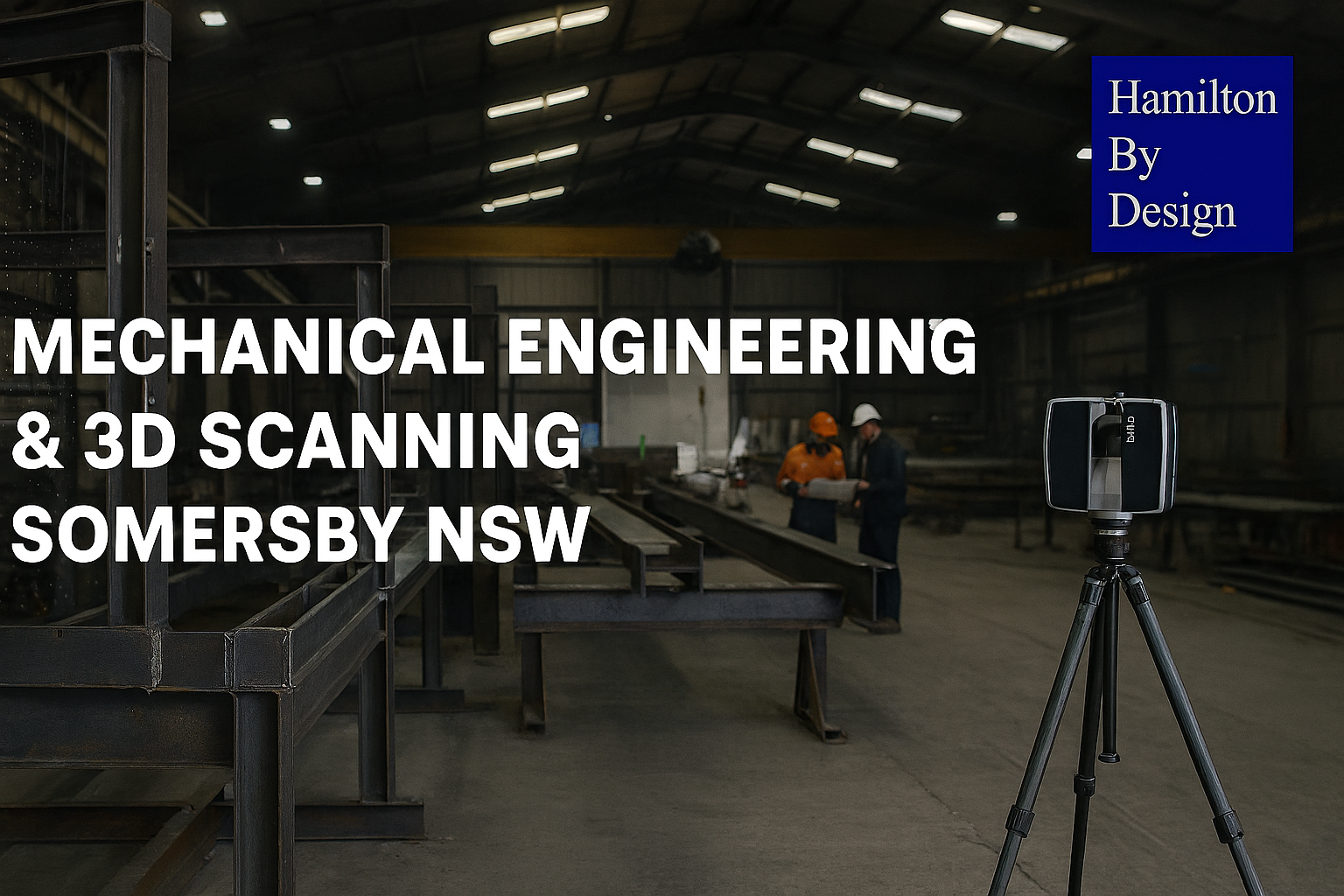
Engineering & Fabrication in Somersby

Structural steel I-beam bolted connection with column in isometric view.

Somersby is one of the Central Coast’s most established industrial precincts, positioned directly off the M1 motorway between Gosford and Sydney. It is home to a strong network of steel fabricators, mechanical workshops, manufacturers, and industrial contractors, making it a key hub for construction, infrastructure, and plant-based projects.

From heavy fabrication yards to specialised engineering workshops, Somersby supports projects that require accuracy, coordination, and buildable design.

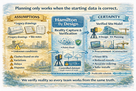
At Hamilton By Design, we work directly with businesses in Somersby to provide engineering-led 3D scanning, mechanical design, and fabrication-ready documentation—ensuring projects fit first time and move efficiently from site to workshop.


Typical Companies in Somersby

The types of businesses you’ll find in Somersby include:

Steel & Structural Fabricators

  • Structural steel workshops
  • Platform, walkway, and access system fabricators
  • Cladding and façade support steel manufacturers

Mechanical & Industrial Engineering Firms

  • Conveyor and materials handling specialists
  • Plant and machinery designers
  • Pump systems and processing equipment suppliers

Industrial Contractors & Builders

  • Mechanical installation contractors
  • Maintenance contractors for industrial plants
  • Construction firms delivering warehouses and infrastructure

Manufacturing & Processing Facilities

  • Food manufacturing plants
  • Packaging and production lines
  • Industrial processing facilities

These businesses rely heavily on accurate as-built data, engineering drawings, and coordination between site and fabrication.


How Hamilton By Design Supports Somersby Projects

3D Laser Scanning (LiDAR) – Site Capture

We capture existing conditions with high accuracy for:

  • Industrial plants and workshops
  • Structural steel and platforms
  • Pipework, conveyors, and mechanical systems
  • Brownfield and retrofit environments

Result:

  • Accurate point clouds ready for design
  • Reduced site rework and RFIs

Scan-to-CAD & As-Built Modelling

We convert site scans into usable engineering data:

  • 3D CAD models (SolidWorks)
  • 2D as-built drawings (plans, sections, elevations)
  • Layouts suitable for fabrication

Result:

  • Fabricators build from real geometry, not assumptions
  • Faster workshop turnaround

Mechanical Engineering & Design

Engineering-led support for:

  • Plant upgrades and modifications
  • Structural steel additions
  • Equipment installation and retrofits
  • Reverse engineering of existing components

Result:

  • Practical designs that match real site conditions
  • Reduced clashes during installation

Fabrication & Installation Support

We work closely with Somersby fabricators to deliver:

  • Fabrication drawings with tolerances
  • Weld details and assembly documentation
  • Fit-up strategies based on scan data

Result:

  • Components fit first time on site
  • Less rework, delays, and downtime

Typical Somersby Project Workflow

  1. Site scan at the Somersby facility or project site
  2. Point cloud processing and registration
  3. 3D modelling and engineering design
  4. Fabrication drawings issued
  5. Workshop fabrication by local fabricator
  6. Installation with minimal adjustment required

This workflow is critical in Somersby, where many projects involve existing structures, tight tolerances, and live industrial environments.


Why Engineering-Led Scanning Matters in Somersby

Somersby projects often involve brownfield conditions, where drawings are outdated or incomplete.

Traditional survey or basic scanning is not enough.

At Hamilton By Design:

  • The engineer is directly involved in the scan
  • Data is captured with fabrication in mind
  • Outputs are immediately usable for design and construction

This removes the gap between site, design, fabrication, and installation.


Local Advantage

Being active on the Central Coast, we understand:

  • Access and site constraints in Somersby
  • Working around active industrial operations
  • Coordination with local fabricators and contractors

This results in faster mobilisation, better communication, and ongoing project support.


Who We Work With in Somersby

  • Steel fabricators
  • Mechanical contractors
  • Industrial maintenance teams
  • Builders and project managers
  • Engineering consultants

Hamilton By Design logo displayed on a blue tilted rectangle with a grey gradient background

Work With Us in Somersby

If your project involves upgrading existing plant, fabricating new steelwork, or installing equipment into an existing structure, we provide accurate site data and engineering support to ensure it is delivered correctly the first time.

Contact Us – Talk to Us


Name
Would you like us to arrange a phone consultation for you?
Address

Our Clients

3D LiDAR scanning services on the Central Coast providing engineering-grade laser scanning, point cloud capture, scan-to-CAD modelling and industrial reality capture for infrastructure and industrial projects.
Drafting services on the Central Coast providing engineering drawings, fabrication detailing, as-built documentation, reverse engineering and CAD drafting for industrial and infrastructure projects.
Mechanical engineering services on the Central Coast providing industrial design, plant inspections, pump calculations, reverse engineering and engineering support for manufacturing, infrastructure and heavy industry projects.

Terrestrial LiDAR Scanner | Engineering-Grade 3D Laser Scanning

Terrestrial LiDAR scanner capturing industrial plant

What is a Terrestrial LiDAR Scanner?

A terrestrial LiDAR scanner is a ground-based 3D laser scanning system used to capture highly accurate measurements of real-world environments and convert them into detailed digital models known as point clouds.

At Hamilton By Design, we use engineering-grade terrestrial LiDAR scanning to support design, drafting, and construction across industrial, mining, and infrastructure projects.


3D LiDAR scanning and 3D modelling service button — laser scanner capturing a point cloud for engineering and CAD modelling
Mechanical engineering services

How a Terrestrial LiDAR Scanner Works

A terrestrial LiDAR scanner measures distance using laser technology:

  • A laser beam is emitted from the scanner
  • The beam reflects off surfaces such as steel, concrete, or pipework
  • The scanner records the return signal
  • Distance is calculated using time-of-flight or phase shift
  • Millions of measurements are captured per second

The result is a dense and accurate 3D point cloud representing the scanned environment.


What is a Point Cloud?

A point cloud is a digital dataset made up of millions (or billions) of points.

Each point contains:

  • X, Y, Z coordinates
  • Spatial position in 3D space
  • Optional colour information (RGB)

This creates a true-to-life digital representation of physical assets, forming the foundation for CAD modelling and engineering design.


Why Use a Terrestrial LiDAR Scanner?

Accuracy

Terrestrial LiDAR scanners provide millimetre-level accuracy, making them suitable for engineering and fabrication.

Speed

Large and complex environments can be captured quickly compared to traditional survey methods.

Safety

Data can be captured without direct access to hazardous or difficult-to-reach areas.

Reduced Rework

Designs are based on real-world data, reducing clashes and site modifications.


3D CAD Modelling Australia service banner for Hamilton By Design

Engineering Applications

Terrestrial LiDAR scanning is widely used across:

  • Industrial plant upgrades
  • Mining and processing facilities
  • Structural and mechanical design
  • Brownfield engineering projects
  • As-built verification
  • Reverse engineering

For projects requiring integration with your team, this capability can also be delivered through our engineering secondment services:
https://www.hamiltonbydesign.com.au/home/secondment-services/


Engineering-Led LiDAR Scanning

Not all LiDAR scanning is equal.

At Hamilton By Design, scanning is performed with an engineering-first approach, ensuring the data is suitable for downstream use in CAD and design.

Key considerations include:

  • Line-of-sight limitations
  • Scan density and coverage
  • Registration accuracy
  • Data structure and usability

This ensures the output is not just a visual model, but a usable engineering dataset.


From Scan to CAD

Our workflow converts LiDAR data into practical deliverables:

Scan → Register → Model → Detail → Deliver

This includes:

  • Point cloud registration (.E57, .RCP, .LAS)
  • 3D CAD modelling (SolidWorks and other platforms)
  • 2D drawings and fabrication-ready documentation

Terrestrial vs Other Scanning Methods

  • Terrestrial LiDAR: High accuracy, long range, ideal for engineering
  • Handheld scanners: Faster but lower accuracy, suited to small objects
  • Photogrammetry: Visual models, not typically engineering-grade

For industrial and brownfield environments, terrestrial LiDAR remains the preferred method.


Terrestrial LiDAR scanner capturing industrial plant with Sydney Harbour Bridge in background

In-House & Secondment Delivery

We provide flexible delivery models to suit your project:

  • In-house scanning and modelling (fully managed)
  • Secondment services (embedded within your team)

Learn more about our secondment capability:
https://www.hamiltonbydesign.com.au/home/secondment-services/


Why Choose Hamilton By Design

  • Engineering-led LiDAR scanning
  • Integration with CAD modelling and drafting
  • Strong experience in industrial and mining environments
  • Brownfield project expertise
  • Practical, buildable outputs

Hamilton By Design logo displayed on a blue tilted rectangle with a grey gradient background

Get Started with Terrestrial LiDAR Scanning

If you require accurate, engineering-grade 3D data for your project, a terrestrial LiDAR scanner provides the foundation for reliable design and execution.

Hamilton By Design delivers scanning, modelling, and engineering support across Sydney and Australia.

Talk to Us – Contact Us

Name
Would you like us to arrange a phone consultation for you?
Address

Why Projects Fail Before Construction Starts

3D scanning reality capture workflow converting legacy drawings into a verified site model for construction planning.

The missing step between site reality and project planning

Most project delays don’t begin during construction.

They begin months earlier — at the planning stage.

Not because engineers lack skill.
Not because contractors lack experience.

But because decisions are made using incomplete or assumed information.


Construction planning comparison between assumed data and verified point-cloud model using laser scanning.

The hidden gap in almost every project

In industrial and brownfield environments, teams typically work from:

  • legacy drawings
  • outdated models
  • partial surveys
  • contractor interpretation
  • verbal site knowledge

Each group fills in the missing details differently.

The result is predictable:

  • clashes discovered during installation
  • materials ordered incorrectly
  • redesign during construction
  • variations and disputes
  • safety risks

The project didn’t fail during construction.
It failed when planning began without verified reality.


Planning systems only work if the starting data is correct

Modern project environments rely heavily on structured planning:

  • scheduling
  • procurement
  • prefabrication
  • shutdown coordination
  • multi-contractor installation

But structured planning requires structured information.

If the starting information is uncertain, the entire workflow becomes an organised way of distributing errors.


The role of a reality-based dataset

Before a project can be planned properly, one thing must exist:

A trusted digital representation of the physical asset

This is not a drawing.
This is not a sketch.
This is not a collection of markups.

It is a measurable, verifiable record of what physically exists.

Once this exists:

  • engineers design accurately
  • planners sequence correctly
  • contractors install confidently
  • procurement orders correctly
  • changes are controlled

What our consultancy provides

Hamilton By Design acts as the bridge between site conditions and project planning.

We provide a structured workflow:

  1. Capture the physical environment using high-accuracy laser scanning
  2. Create a controlled digital model of the asset
  3. Make the data accessible to all project stakeholders
  4. Lock the dataset during design and upgrade phases
  5. Update the dataset following modifications

This creates a single project reference — removing interpretation between disciplines.


The outcome for projects

Instead of discovering problems during installation, they are resolved during planning.

Instead of managing variations, teams manage decisions.

Instead of reacting to site conditions, teams design around verified reality.


The value of independent verification

Our role is not to design the system or build the works.

Our role is to ensure every party begins with the same trusted information.

When reality is agreed, coordination becomes straightforward.


Before planning, establish certainty

Projects do not fail because teams are incapable.
They fail because teams start from different assumptions.

Providing a verified digital record of the site removes those assumptions.

And once assumptions disappear — so do most surprises.


Hamilton By Design
Creating trusted project reality before planning begins.

Name
Would you like us to arrange a phone consultation for you?
Address


3D LiDAR scanning and 3D modelling service button — laser scanner capturing a point cloud for engineering and CAD modelling
Mechanical engineering services
Finite Element Analysis (FEA) engineering simulation button
Mechanical engineering services