3D LiDAR Scanning Solutions Australia: Capturing Engineering-Grade Accuracy for Mining, Industrial & Infrastructure Projects

3D LiDAR scanning has rapidly become one of Australiaโ€™s most valuable engineering tools โ€” and for good reason. From mining CHPPs to power stations, manufacturing plants, processing facilities, marine infrastructure, and complex brownfield upgrades, LiDAR delivers accuracy, clarity, and reliability that traditional measurement methods simply canโ€™t match.

Across Australiaโ€™s most demanding industrial regions โ€” the Hunter Valley, Bowen Basin, Pilbara, Mount Isa, Central Coast, Sydney, Adelaide, and beyond โ€” Hamilton By Design provides engineering-grade 3D LiDAR scanning, mechanical design, and full digital-engineering workflows that help clients minimise shutdown duration, eliminate rework, and make better decisions.

This page explains what 3D LiDAR scanning is, why it matters, and how it delivers real, measurable benefits to Australian mining, industrial, and manufacturing operations.


What Is 3D LiDAR Scanning?

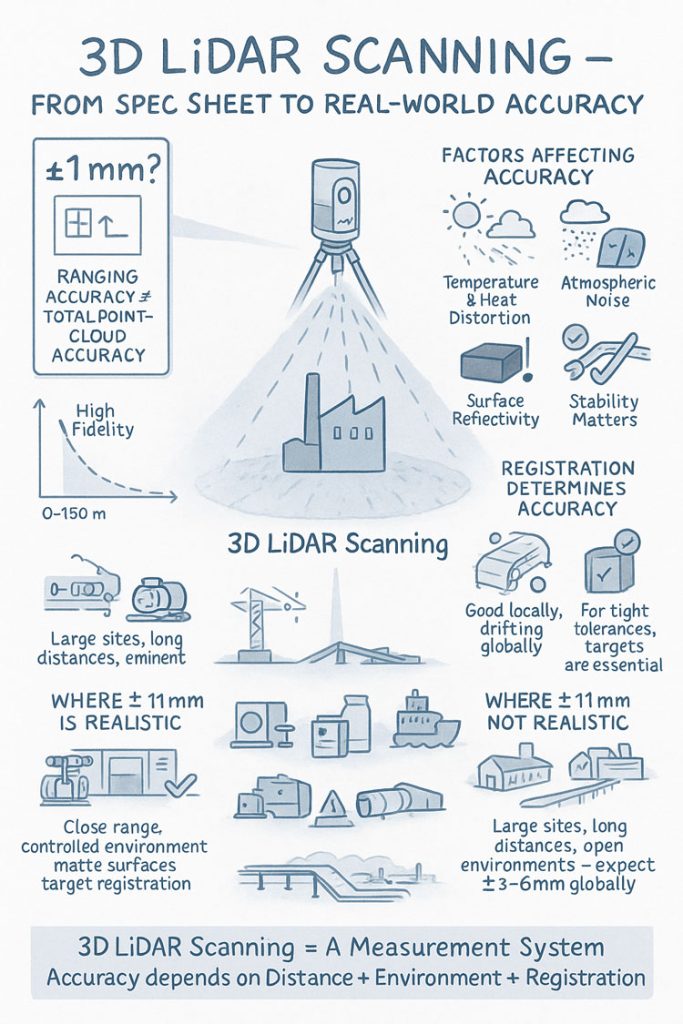
LiDAR (Light Detection and Ranging) uses laser pulses to measure millions of points per second, capturing the exact geometry of equipment, structures, and environments. The result is a high-resolution point cloud that serves as a digital replica of the asset โ€” precise down to the millimetre.

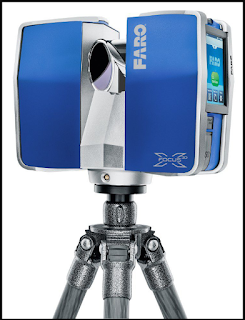
Hamilton By Design uses FARO engineering-grade scanners delivering:

  • ยฑ1โ€“2 mm accuracy
  • Full-colour point clouds
  • Safe, fast external and internal scanning
  • High-resolution data suitable for mechanical design and fabrication

This accuracy allows us to model steelwork, chutes, conveyors, piping, tanks, equipment frames, building interiors, structural interfaces, and entire wash plants with confidence.


Why Australian Industries Are Turning to LiDAR

Australiaโ€™s mining, energy, and industrial sectors face unique pressures:
tight shutdown windows, ageing infrastructure, safety constraints, limited access, and the constant demand for more accurate data.

LiDAR scanning solves these challenges by offering:

1. Fast, Safe, Non-Contact Measurement

No climbing into hazardous areas.
No lengthy tape measurements.
No assumptions.

LiDAR captures everything from a safe distance โ€” ideal for CHPPs, crushing circuits, transfer towers, power stations, and restricted plant rooms.


2. Zero Guesswork in Brownfield Engineering

Brownfield sites are messy. Nothing is straight, square, or built to the original drawing anymore.

With LiDAR:

  • Misalignment is captured
  • Deformation is visible
  • Corrosion and sag are measurable
  • Legacy drawings can be validated or corrected

This drastically reduces design error across upgrades, fabrication, and shutdown works.


3. Millimetre-Accurate 3D Models for Fabrication

After scanning, Hamilton By Design converts the point cloud into:

  • SolidWorks 3D models
  • GA drawings
  • Fabrication drawings
  • DXF profiles
  • Shop-ready detail packs

Fabricators love it because parts fit the first time, and rework is almost eliminated.


4. Better Shutdown Planning

LiDAR scanning provides clear digital visibility of:

  • Access routes
  • Lifting paths
  • Structural constraints
  • Tie-in locations
  • Clash points

This leads to safer, faster, more predictable shutdown execution.


5. Digital Twins for Long-Term Asset Management

A structured point cloud becomes a digital baseline for future planning.
Clients use it for:

  • Condition monitoring
  • Deviation tracking
  • Long-term upgrade planning
  • Documentation for compliance

It builds engineering resilience into the asset lifecycle.


Industries We Support Across Australia

Hamilton By Design delivers LiDAR scanning and mechanical engineering solutions nationwide, supporting:

Mining & Heavy Industry

  • CHPPs
  • Coal handling plants
  • Hard-rock processing facilities
  • Underground & surface operations
  • Conveyors, chutes, crushers, screen houses

Energy & Utilities

  • Power stations
  • Turbine halls
  • Boiler houses
  • Substations
  • Cooling water systems

Manufacturing & Industrial

  • Plants and factories
  • Production lines
  • Warehouses
  • Material-handling systems

Data Centres & Infrastructure

  • Fit-out scans
  • MEP coordination
  • Expansion planning
  • Brownfield integration

Wherever precision and clarity are required, LiDAR scanning adds value.


Our Digital Engineering Workflow

Hamilton By Design integrates LiDAR scanning into a full project lifecycle:

  1. On-site LiDAR scan using FARO engineering-grade equipment
  2. Processing in FARO Scene to create a clean, structured point cloud
  3. Import into SolidWorks for modelling of required geometry
  4. 3D modelling & mechanical design
  5. Clash detection & feasibility checks
  6. 3DEXPERIENCE reviews with clients
  7. Fabrication drawings, DXF files, and shop packs
  8. Handover + digital twin for future works

This ensures absolute clarity from the first scan to the final signed-off drawing.


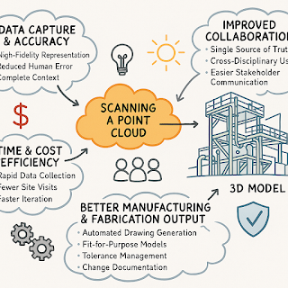
Benefits for Australian Projects

โœ” Parts fit first time

โœ” Shutdown durations reduced

โœ” Fabricators receive complete, accurate information

โœ” Safer site access with fewer high-risk activities

โœ” Eliminates rework, delays, and measurement errors

โœ” Enhances engineering collaboration

โœ” Reduces total project cost

LiDAR scanning isnโ€™t just a measurement method โ€” itโ€™s a competitive advantage.


Why Choose Hamilton By Design

  • Over a decade of experience in heavy industry
  • Extensive CHPP and mining plant expertise
  • SolidWorks Simulation, FEA, and advanced modelling capability
  • Fast mobilisation across Australia
  • Detailed, fabrication-ready deliverables
  • LinkedIn-trusted and industry-proven
  • Engineering accuracy at every step

For clients across the Hunter Valley, Bowen Basin, Pilbara, NSW, QLD, WA, and SA โ€” we offer scalable, high-precision digital engineering that delivers reliability and confidence.


Hamilton By Design logo displayed on a blue tilted rectangle with a grey gradient background
3D LiDAR scanning and 3D modelling service button โ€” laser scanner capturing a point cloud for engineering and CAD modelling
Mechanical engineering services

Ready to Start Your Project?

Hamilton By Design offers 3D LiDAR scanning anywhere in Australia, from mine sites to manufacturing plants to data centres.

If youโ€™re planning:

  • an upgrade
  • a shutdown
  • a brownfield expansion
  • a feasibility study
  • or an equipment replacement

โ€ฆLiDAR scanning is the smartest starting point.

Contact us today to book a site scan or request a proposal.

Name
Address
You would like to:

3D Point Clouds Are a Game-Changer for Your Projects

Your Experts in 3D Laser Scanning & Mechanical Design

3D CAD Modelling | 3D Scanning

3D Experience Platform Login

Finite Element Analysis (FEA) engineering simulation button
Mechanical engineering services

The Real-World Accuracy of 3D LiDAR Scanning With FARO S150 & S350 Scanners

When people first explore 3D LiDAR scanning, one of the most eye-catching numbers in any product brochure is the advertised accuracy. FAROโ€™s Focus S150 and S350 scanners are often promoted as delivering โ€œยฑ1 mm accuracy,โ€ which sounds definitive and easy to rely on for engineering, mining and fabrication work. But anyone who has spent time working with 3D LiDAR scanning in real industrial environments understands that accuracy isnโ€™t a single number โ€” it is a system of interrelated factors.

This article explains what the ยฑ1 mm specification from FARO really means, how accuracy shifts with distance, and what engineers, project managers and clients need to do to achieve dependable results when applying 3D LiDAR scanning on live sites.

3D LiDAR scanning and 3D modelling service button โ€” laser scanner capturing a point cloud for engineering and CAD modelling
Mechanical engineering services

Infographic explaining 3D LiDAR scanning accuracy, showing a scanner capturing a building and highlighting factors that affect accuracy such as temperature, atmospheric noise, surface reflectivity and tripod stability. Includes diagrams comparing realistic versus unrealistic ยฑ1 mm accuracy, the impact of distance, environment and registration quality, and notes that large open sites typically achieve ยฑ3โ€“6 mm global accuracy.

1. What FAROโ€™s โ€œยฑ1 mm Accuracyโ€ Really Means in 3D LiDAR Scanning

The ยฑ1 mm number applies only to the internal distance measurement unit inside the scanner. It reflects how accurately the laser measures a single distance in controlled conditions.

It does not guarantee:

  • ยฑ1 mm for every point in a full plant model
  • ยฑ1 mm for every dimension extracted for engineering
  • ยฑ1 mm global accuracy across large multi-scan datasets

In 3D LiDAR scanning, ranging accuracy is just one ingredient. Real-world accuracy is shaped by distance, reflectivity, scan geometry and how multiple scans are registered together.


2. How Accuracy Changes With Distance in Real Projects

Even though the S150 and S350 list the same ranging accuracy, their 3D LiDAR scanning performance changes as distance increases. This is due to beam divergence, angular error, environment and surface reflectivity.

Typical real-world behaviour:

  • 0โ€“10 m: extremely precise, often sub-millimetre
  • 10โ€“25 m: excellent for engineering work, only slight noise increase
  • 25โ€“50 m: more noticeable noise and increasing angular error
  • 50โ€“100 m: atmospheric distortion and reduced overlap become evident
  • Near maximum range: still useful for mapping conveyors, yards and structures, but not suitable for tight fabrication tolerances

This distance-based behaviour is one of the most important truths to understand about 3D LiDAR scanning in field conditions.


3. Ranging Accuracy vs Positional Accuracy vs Global Accuracy

Anyone planning a project involving 3D LiDAR scanning must distinguish between:

Ranging Accuracy

The ยฑ1 mm value โ€” only the distance measurement.

3D Positional Accuracy

The true X/Y/Z location of a point relative to the scanner.

Global Point Cloud Accuracy

How accurate the entire dataset is after registration.

Global accuracy is the number engineers depend on, and it is normally around ยฑ3โ€“6 mm for large industrial sites โ€” completely normal for terrestrial 3D LiDAR scanning.


4. What Real Field Testing Reveals About FARO S-Series Accuracy

Independent practitioners across mining, infrastructure, CHPPs, plants and structural environments report similar results when validating 3D LiDAR scanning against survey control:

  • ยฑ2โ€“3 mm accuracy in compact plant rooms
  • ยฑ5โ€“10 mm across large facilities
  • Greater drift across long, open, feature-poor areas

These outcomes are not equipment faults โ€” they are the natural result of how 3D LiDAR scanning behaves in open, uncontrolled outdoor environments.


5. Why Registration Matters More Than the Scanner Model

Most real-world error in 3D LiDAR scanning comes from registration, not the laser itself.

Cloud-to-Cloud Registration

Good for dense areas, less reliable for long straight conveyors, open yards or tanks.

Target-Based Registration

Essential for high-precision engineering work.
Allows tie-in to survey control and dramatically improves global accuracy.

If your project needs ยฑ2โ€“3 mm globally, target control is mandatory in all 3D LiDAR scanning workflows.


6. Surface Reflectivity and Environmental Effects

Reflectivity dramatically affects measurement quality during 3D LiDAR scanning:

  • Matte steel and concrete return excellent data
  • Rusted surfaces return good data
  • Dark rubber, black plastics and wet surfaces reduce accuracy
  • Stainless steel and glass behave unpredictably

Environmental factors โ€” wind, heat shimmer, dust, rain โ€” also reduce accuracy. Early morning or late afternoon typically produce better 3D LiDAR scanning results on mining and industrial sites.


7. When ยฑ1 mm Is Actually Achievable

True ยฑ1 mm accuracy in 3D LiDAR scanning is realistic when:

  • Working within 10โ€“15 m
  • Surfaces are matte and reflective
  • Registration uses targets
  • Tripod stability is high
  • Conditions are controlled

This makes it suitable for:

  • Pump rooms
  • Valve skids
  • Structural baseplates
  • Reverse engineering
  • Small mechanical upgrades

But achieving ยฑ1 mm across a full plant, CHPP, or yard is outside the capability of any terrestrial 3D LiDAR scanning workflow.


8. S150 vs S350: Which One for Your Accuracy Needs?

S150 โ€“ Engineering-Focused Precision

Ideal for industrial rooms, skids, structural steel and retrofit design work where short-to-mid-range accuracy is essential.

S350 โ€“ Large-Area Coverage

Perfect for conveyors, rail lines, yards, and outdoor infrastructure.
Global accuracy must be survey-controlled for tight tolerances.

Both scanners deliver excellent 3D LiDAR scanning performance, but the S150 is the engineering favourite while the S350 is the large-site specialist.


9. What to Specify in Contracts to Avoid Misunderstandings

Instead of stating:

โ€œScanner accuracy ยฑ1 mm.โ€

Specify:

  • Local accuracy requirement (e.g., ยฑ2 mm at 15 m)
  • Global accuracy requirement (e.g., ยฑ5 mm total dataset)
  • Registration method (mandatory target control)
  • Environmental constraints
  • Verification method (e.g., independent survey checks)

This ensures everyone understands what 3D LiDAR scanning will realistically deliver.


10. When a Terrestrial Scanner Is Not Enough

Do not rely solely on 3D LiDAR scanning for:

  • Machine alignment <1 mm
  • Bearing or gearbox placement
  • Certified dimensional inspection
  • Metrology-level tolerances

In these cases, supplement scanning with:

  • Laser trackers
  • Total stations
  • Metrology arms
  • Hybrid workflows

Conclusion: The Real Truth About 3D LiDAR Scanning Accuracy

FAROโ€™s S150 and S350 are outstanding tools for industrial 3D LiDAR scanning, but the ยฑ1 mm spec does not tell the full story. Real-world accuracy is a combination of:

  • Distance
  • Registration method
  • Surface reflectivity
  • Site conditions
  • Workflow discipline

When used correctly, these scanners consistently deliver high-quality, engineering-grade point clouds suitable for clash detection, retrofit design, fabrication planning and as-built documentation.

3D LiDAR scanning is not just a laser โ€” it is an entire measurement system.
And when the system is applied with care, it produces reliable, repeatable data that reduces rework, improves safety, and strengthens decision-making across mining, construction, fabrication and industrial operations.

Where Is your project

3D Scanning Sydney CBD3D Scanning Brisbane CBD
3D Scanning across Melbourne3D Scanning across Perth
3D Scanning across Adelaide3D Scanning in The Hunter Valley
3D Scanning Mount Isa3D Scanning Emerald
3D Laser Scanning Central Coast3D Scanning in The Pilbara
3d Scanning other Areas of Australia3D Scanning Outside Australia
Hamilton By Design logo displayed on a blue tilted rectangle with a grey gradient background
3D LiDAR scanning and 3D modelling service button โ€” laser scanner capturing a point cloud for engineering and CAD modelling
Mechanical engineering services
Name
Address
You would like to:

3D CAD Modelling | 3D Scanning

3D Experience Platform Login

3D Scanning for Construction

Transforming Projects with 3D Scanning

3D LiDAR Scanning โ€“ Digital Quality Assurance

Are You Getting the Full Value from Your Point Cloud Data?

3D Scanning

The world of manufacturing and fabrication is moving faster than ever. Point cloud scanning and 3D modeling have made it easier to capture reality with incredible accuracy โ€” but simply collecting data isnโ€™t enough.

Without the right expertise, point clouds often sit unused, underutilized, or worse โ€” lead to costly mistakes when converted into incomplete or inaccurate drawings.

3D Scanning

Thatโ€™s why mechanical engineering consultants are becoming essential partners for forward-thinking businesses. They donโ€™t just process point clouds โ€” they turn them into:

  • High-precision 3D models that match real-world conditions

  • Fabrication-ready drawings that reduce errors and rework

  • Actionable insights that save time, money, and frustration

This is no longer just about technology โ€” itโ€™s about strategy and execution.

Read our full article to discover why now is the perfect time to engage consultants who can unlock the power of your point cloud data:


Itโ€™s Time to Level Up: Why Mechanical Engineering Consultants Are Key to Unlocking the Power of Point Cloud to 3D Modeling

ย 
3D LiDAR scanning and 3D modelling service button โ€” laser scanner capturing a point cloud for engineering and CAD modelling
Mechanical engineering services

Hamilton By Design logo displayed on a blue tilted rectangle with a grey gradient background

Our clients:

Name
Would you like us to arrange a phone consultation for you?
Address
3D LiDAR scanning and 3D modelling service button โ€” laser scanner capturing a point cloud for engineering and CAD modelling
Mechanical engineering services
Finite Element Analysis (FEA) engineering simulation button
Mechanical engineering services

Precision Engineering with Hamilton By Design

In the world of modern design and engineering, precision is everything. Hamilton By Design has mastered the art of integrating cutting-edge technology to create seamless, high-quality solutions for their clients. Their approach combines advanced scanning tools with powerful design software to ensure every project is executed with accuracy and efficiency.ย ย 

The Power of 3D Scanningย ย 

Hamilton By Design utilizes state-of-the-art 3D scanning technology to capture detailed measurements of existing structures and components. This process allows them to create highly accurate digital representations of physical objects, ensuring that every design fits perfectly within the intended space. By leveraging this scanning capability, they eliminate guesswork and significantly reduce the margin for error in complex projects.ย ย 

ย 

Seamless Integration with Design Softwareย ย 

Once the scanned data is collected, Hamilton By Design employs industry-leading design software to transform raw point clouds into refined, functional models. This enables them to develop components that integrate flawlessly with existing structures, ensuring a perfect fit every time. Their expertise in working with scanned geometry allows them to streamline workflows, enhance efficiency, and deliver superior results.ย ย 

Innovation in Every Projectย ย 

Hamilton By Designโ€™s commitment to precision and innovation sets them apart in the industry. By combining advanced scanning technology with powerful design tools, they create solutions that are not only functional but also optimized for performance and longevity. Their approach ensures that every project meets the highest standards of accuracy and quality, making them a trusted partner for businesses seeking cutting-edge engineering solutions.ย ย 

Partner with Hamilton By Designย ย 

Looking to elevate your next project with unmatched precision and expertise? Hamilton By Design is ready to bring your vision to life. Connect with their team today and discover how their advanced approach can turn your ideas into reality.ย ย 

3D LiDAR scanning and 3D modelling service button โ€” laser scanner capturing a point cloud for engineering and CAD modelling
Mechanical engineering services

Our clients:

Name
Would you like us to arrange a phone consultation for you?
Address

Scan to CAD Sydney

3D LiDAR Laser Scanning & Drafting Services in Chatswood & Greater Sydney

Mechanical Engineers in Sydney โ€“ Hamilton By Design

Finite Element Analysis (FEA) engineering simulation button
Mechanical engineering services