SMP Projects: Enabling Project Success Through a Scan โ†’ Design โ†’ Scan Workflow

Watercolour-style illustration showing SMP 3D laser scanning workflow from start capture to clash-free design and final digital as-built.

Successful Structural, Mechanical and Piping (SMP) projects are built on one fundamental principle: decisions must be based on accurate knowledge of existing conditions. In brownfields industrial environments, legacy drawings and manual measurements rarely reflect the current state of an asset. Over years of operation, piping is rerouted, structures are strengthened, and equipment is modified to meet changing production demands.

Commencing design on the basis of incomplete or inaccurate information introduces uncertainty that can affect safety, cost, schedule, and quality. Modern 3D laser scanning provides a disciplined method to remove this uncertainty and establish a reliable foundation for project delivery.


Establishing a Reliable Baseline

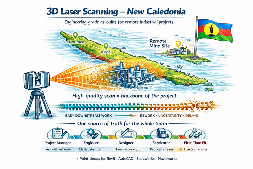
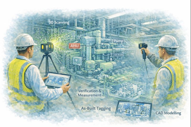
An initial 3D laser scan captures a high-resolution digital representation of the facility, recording structural elements, mechanical equipment, and piping systems exactly as they exist. This dataset becomes the authoritative reference for all subsequent engineering activities.

By beginning with a comprehensive reality capture, project teams can:

  • Define accurate tie-in locations for new works
  • Understand spatial constraints and access requirements
  • Identify potential clashes before detailed design
  • Reduce reliance on manual surveys and assumptions
  • Provide designers with objective, measurable data

This approach aligns engineering decisions with actual site conditions, supporting informed planning and reducing the likelihood of downstream rework.


SMP scanโ€“designโ€“scan process illustrated with laser scanner, point cloud model and finished industrial plant.

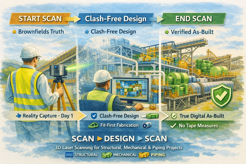
Designing From Truth Rather Than Assumption

When the design phase is grounded in verified scan data, coordination across structural, mechanical, and piping disciplines becomes more effective. Engineers are able to develop models that reflect the real environment rather than an idealised interpretation of it.

The benefits to project success include:

  • Improved accuracy of fabrication documentation
  • Reduced design revisions and RFIs
  • Greater confidence in constructability
  • More reliable cost and schedule forecasting
  • Enhanced collaboration between designers, fabricators, and site teams

A scan-based workflow supports the objective of โ€œfit-firstโ€ construction, where components are manufactured with confidence that they will integrate with existing assets.


Verifying Outcomes With a Final Scan

Project success is not only measured by installation, but by the quality of information handed to the asset owner. A second 3D scan at project completion provides a verified digital as-built of all SMP works.

This final dataset delivers:

  • An accurate record of installed structural, mechanical, and piping systems
  • Validation that construction matches design intent
  • A foundation for maintenance and asset management
  • Reliable data for future modifications or expansions
  • Elimination of manual tape-based as-built surveys

The organisation is left with a living digital asset rather than static drawings that quickly lose relevance.


Supporting Measurable Project Outcomes

Adopting a Scan โ†’ Design โ†’ Scan methodology directly contributes to recognised measures of project success:

  • Safety: Reduced site rework and unplanned interventions
  • Cost Control: Fewer field modifications and claims
  • Schedule Reliability: Shorter shutdowns and predictable installation
  • Quality: Higher confidence in alignment and tolerances
  • Knowledge Retention: Creation of enduring digital records

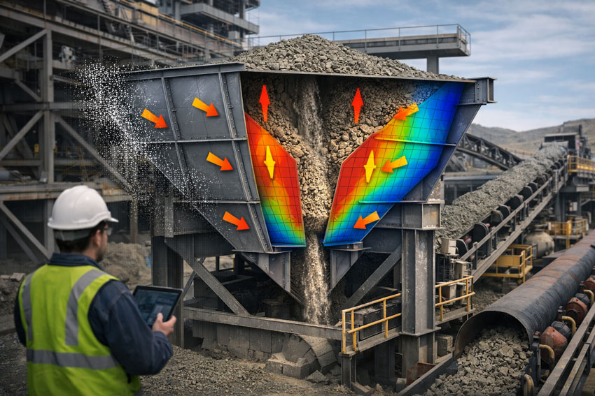
These outcomes are particularly critical in SMP environments where interfaces between steel, equipment, and piping are complex and tolerances are unforgiving.


Applications Across Industrial Sectors

This workflow is suited to a wide range of SMP activities, including:

  • Conveyor and materials handling upgrades
  • Plant expansions and debottlenecking
  • Tank, hopper and bin modifications
  • Piping reroutes and tie-ins
  • Shutdown and turnaround works
  • Brownfields engineering studies

In each case, accurate spatial data enables better engineering judgement and more predictable project delivery.


Hamilton By Design logo displayed on a blue tilted rectangle with a grey gradient background

A Framework for Sustainable Project Success

For organisations seeking consistent performance from SMP projects, the integration of 3D laser scanning is not a survey exerciseโ€”it is a strategic project control measure. By capturing reality at project commencement and verifying it at completion, stakeholders gain confidence that engineering decisions, construction outcomes, and asset records are aligned.

Start with verified data.
Design with confidence.
Finish with a true digital as-built.

Hamilton By Design Co. partners with project teams to implement this approach, supporting safer, more reliable, and more successful SMP outcomes.

Name
Would you like us to arrange a phone consultation for you?
Address

3D Laser Scanning in New Caledonia โ€“ Engineering Certainty in a Remote Environment

Illustration of 3D laser scanning in New Caledonia showing a LiDAR scanner capturing an industrial site over a coloured map with the Kanak flag and point cloud overlay.

3D Laser Scanning New Caledonia | Hamilton By Design

Engineering projects in New Caledonia operate in a unique environment. Nickel processing plants, port facilities, power stations and infrastructure are often decades old, heavily modified and located far from design offices. Accurate site information is the difference between a smooth project and an expensive lesson.

3D laser scanning has become the most reliable way to capture existing conditions across Noumรฉa, Konรฉ and the remote mine sites of the Grande Terre. Instead of relying on tape measures and assumptions, LiDAR technology records millions of precise measurements to create a true digital twin of the asset.


The Challenge of Brownfields Projects in New Caledonia

Many facilities in New Caledonia share the same constraints:

  • Limited shutdown windows
  • Corrosive coastal environments
  • Historical modifications with poor drawings
  • Logistics that make repeat site visits costly
  • Multi-discipline coordination between local and overseas teams

Traditional survey methods struggle to capture congested pipe racks, structural steel distortions or equipment that has shifted over time. When drawings do not match reality, fabrication delays and site rework quickly follow.


3D laser scanning New Caledonia graphic with national colours, flag on map, industrial facility and workflow from scan to first-time fit.

The Scan Is the Backbone of the Project

The initial scan quality sets the tone for every task that follows. The point cloud becomes the backbone of the projectโ€”design, detailing, fabrication and construction all rely on it.

If you start with a broken backbone, you will have problems everywhere else:

  • Simple tasks become difficult
  • Measurements are questioned
  • models need rework
  • fabricators lose confidence
  • schedules start to slip

A clean, well-registered scan makes coordination easy. A poor scan multiplies effort for every member of the team.


Protecting the Whole Project Team

3D laser scanning is not just about creating a modelโ€”it is about protecting everyone involved:

  • Project managers who must control time and cost
  • Engineers responsible for safe and compliant designs
  • Designers and draftspersons who need reliable geometry
  • Fabricators who must build components that fit
  • Construction crews who install the work on short shutdowns

When the as-built data is right, the entire chain works with confidence. When it is wrong, every discipline inherits the problem.


How 3D Laser Scanning Changes the Outcome

A terrestrial laser scanner captures a complete point cloud of the site in hours rather than weeks. The data can then be used for:

  • Accurate as-built models for upgrades and expansions
  • Tie-in design for new conveyors, tanks and platforms
  • Structural verification of aging infrastructure
  • Clash detection before fabrication
  • Shutdown planning and risk reduction
  • Asset documentation for long-term maintenance

For New Caledonian projects, the biggest benefit is capture once, design anywhere. Local scanning crews can collect the data while engineering teams in Australia or New Zealand work from the same digital environment without further travel.


Typical Applications Across New Caledonia

Mining & Processing

  • Nickel plant upgrades
  • Conveyor replacements
  • Chute and transfer redesign
  • Tank and thickener modifications
  • Access platforms and walkways

Ports & Infrastructure

  • Wharf structural assessments
  • Ship loader interfaces
  • Pipe bridges and services
  • Electrical and control building upgrades

Energy & Utilities

  • Power station retrofits
  • Water treatment facilities
  • Fuel storage terminals

From Point Cloud to Deliverables

A professional workflow generally includes:

  1. On-site LiDAR capture with survey control
  2. Registration and quality assurance
  3. Creation of usable formats for Revit, AutoCAD, SolidWorks or Navisworks
  4. Extraction of models, drawings or clash reports
  5. Ongoing support during fabrication and installation

The result is engineering data you can trustโ€”without the need for multiple trips to site.


Hamilton By Design logo displayed on a blue tilted rectangle with a grey gradient background

Ready to De-Risk Your Project?

Whether your project is in Noumรฉa, Konรฉ or a remote mine site, 3D laser scanning provides the foundation for safe, predictable and efficient engineering. Get the backbone right at the start and the rest of the project becomes easier.


Name
Would you like us to arrange a phone consultation for you?
Address

Mechanical Engineering Support for PNG

Engineer using LiDAR scanner to capture mining and processing plant within a map of Papua New Guinea for engineering design and plant upgrades.

Fly-In Data Capture โ†’ Australian Analysis โ†’ Capacity Outcomes

Engineer-Led. Practical. Here to Support You.

Hamilton By Design Co. is an engineer-led team that wants to support you. We connect Papua New Guinea mine sites with experienced Australian engineers and designersโ€”flying in to collect your engineering data, then analysing it in Australia to develop upgrades that help you extract the most from your opportunity.

Donโ€™t feel isolated because of your remotenessโ€”weโ€™re here to help.
Our role is to stand beside your site teams, capture what really exists, and convert that into practical actions that increase capacity, reliability, and safety.

We adapt our systems to fit yours.
Whatever platforms, standards, and workflows your operation already uses, we structure our deliverables to integrate seamlessly with your established processes.


Papua New Guinea industrial facility being digitally captured with 3D scanning to create accurate models for remote engineering and shutdown planning.

To Mine Management โ€“ This Is About Value

You are responsible for getting maximum performance from existing assets while controlling risk and downtime. Hamilton By Design works directly with management to:

  • Identify constraints limiting throughput
  • Reduce uncertainty before capital decisions
  • Turn real conditions into structured engineering plans
  • Deliver upgrades that increase production, not just paperwork

Our focus is outcomes:
Accurate site capture โ†’ Australian engineering analysis โ†’ measurable capacity improvement.


How We Support Your Operation

1. Fly-In Engineering Data Collection

We mobilise to your PNG site to:

  • Capture accurate engineering information across plants, structures, conveyors, tanks, and services
  • Verify tie-ins, access constraints, and maintenance issues
  • Validate legacy drawings against reality
  • Engage with operators to understand bottlenecks and operating challenges

2. Australian Engineering & Design

Back in Australia our team will:

  • Structure the site data into design-ready formats that suit your systems
  • Analyse structural and mechanical limits
  • Develop options to increase process capacity
  • Produce constructable drawings and work packs for shutdown execution
  • Coordinate with your project teams, fabricators, and contractors

3. Capacity & Reliability Outcomes

Everything is aimed at real improvement:

  • Debottlenecking of chutes and conveyors
  • Structural upgrades for higher loads
  • Safer access and maintenance routes
  • Brownfields tie-ins with minimal downtime
  • Reduced rework through accurate as-builts
  • Practical staging to suit your shutdown strategy

PNG Mines We Can Support

Hamilton By Design can service major operations including:

  • Lihir (Niolam) Gold Mine โ€“ tanks, structures, plant interfaces
  • Porgera Gold Mine โ€“ restart and upgrade documentation
  • Ok Tedi โ€“ remote infrastructure and processing areas
  • Hidden Valley โ€“ mountainous brownfields upgrades
  • Simberi โ€“ ROM and conveyor systems
  • Kainantu โ€“ surface/underground interface zones

Why Work With Us

  • Engineer-led team focused on supporting you
  • We come to siteโ€”no desk assumptions
  • Australian engineers with mining exposure
  • Deliverables aimed at throughput and reliability
  • Understanding of PNG logistics and shutdown pressures
  • Independent, practical, constructable solutions
  • Flexible approach that adapts to your existing systems

Hamilton By Design logo displayed on a blue tilted rectangle with a grey gradient background

Typical Deliverables

  • Registered site data and as-built information
  • General arrangement and interface drawings
  • Capacity upgrade concepts
  • Brownfields modification packages
  • Photo-annotated engineering reports
  • Shutdown execution and staging plans

Remote Site? Youโ€™re Not Alone.

No matter how remote your operation, you donโ€™t have to tackle engineering challenges on your own. Hamilton By Design can be on the ground capturing your plant conditions and in Australia turning that data into actions that increase production.


Letโ€™s Talk About Your Opportunity

If you are responsible for getting more from your mine, we can help you:

  • See clearly what exists today
  • Plan upgrades with confidence
  • Deliver changes that actually lift capacity

Contact Hamilton By Design Co.

  • Request a PNG engineering support proposal
  • Plan a fly-in site visit
  • Discuss shutdown and capacity objectives

3D Laser Scanning Perth

Engineers using LiDAR scanning at a construction site within the outline of Western Australia to support structural and building services design.

3D Laser Scanning Perth | Engineering-Grade LiDAR & Scan-to-CAD

Engineering-grade LiDAR scanning for industrial, mining and infrastructure projects across Perth and Western Australia.

If youโ€™re planning an upgrade, shutdown or retrofit, accurate as-built data is critical. Hamilton By Design provides engineering-led 3D laser scanning (LiDAR) to capture high-accuracy point clouds that can be used directly for scan-to-CAD modelling, clash detection, fabrication planning and as-built documentation.

We donโ€™t just capture scans โ€” we deliver reality capture that supports real engineering decisions.


3D laser scanning being used on a Western Australian building site to support engineering design and clearance checks.

What We Deliver

Depending on your project, deliverables can include:

  • Registered point clouds (E57, RCP, RCS)
  • 2D plans, sections and elevations
  • Scan-to-CAD models (mechanical, structural, piping)
  • Interface models for replacement components
  • Clash detection and constructability reviews
  • Updated as-built documentation after installation

When 3D Scanning Is the Right Tool

3D laser scanning is ideal when accuracy matters and rework must be avoided:

  • Plant upgrades and brownfield modifications
  • Shutdown planning and tie-ins
  • Structural platforms and access upgrades
  • Pipework reroutes in congested areas
  • Equipment replacement where OEM lead times are long
  • Verification of clearances and interfaces
  • Asset documentation and digital twin foundations

Industries We Support in WA

  • Mining and mineral processing
  • Oil and gas and energy
  • Ports and materials handling
  • Water and wastewater treatment
  • Manufacturing and heavy industry
  • Building services where engineering accuracy is required

Hamilton By Design logo displayed on a blue tilted rectangle with a grey gradient background

Why Engineering-Grade LiDAR Matters

Not all โ€œ3D scanningโ€ is the same. For industrial and engineering outcomes, you need:

  • Millimetre-level accuracy
  • Long-range capture across large facilities
  • Reliable registration and QA checks
  • Data that integrates directly into CAD workflows

Visual scanning may suit walkthroughs and documentation, but when your project involves fabrication, tie-ins and installation, engineering-grade LiDAR is usually essential.


Our Workflow

  1. Define scope and accuracy requirements
  2. On-site capture with minimal disruption
  3. Registration and quality assurance checks
  4. Delivery of point clouds and/or CAD models
  5. Optional scan-to-CAD modelling and drawings for fabrication

This approach reduces site re-visits and ensures the data is fit for engineering use.


Why Hamilton By Design

  • Engineering-led team, not just scanning operators
  • Practical deliverables for construction and fabrication
  • Strong experience in operating industrial environments
  • Clear scope, consistent QA and project-ready outputs

Perth and WA Coverage

We support projects across Perth metro and regional Western Australia, including:

  • Kwinana and Rockingham industrial precincts
  • Henderson and Naval Base
  • Port of Fremantle
  • Project-based mobilisation to Pilbara and Goldfields sites

Request a Quote

If you need 3D laser scanning in Perth, send through your site location, required deliverables and project timeframe. Weโ€™ll recommend the right capture approach and provide a clear quote.

Contact us to discuss your project.

Name
Would you like us to arrange a phone consultation for you?
Address

Engineering 3D Scanning for Mining Projects in Zambia

Engineer using LiDAR scanner to capture copper processing plant and open-pit mine within a map of Zambia for engineering design and upgrade planning.

Engineering 3D Scanning for Mining Projects in Zambia

Supporting safer, faster and more accurate plant upgrades across the Copperbelt

Zambia is one of Africaโ€™s most important copper-producing nations, with large-scale mining and mineral processing facilities operating across the Copperbelt region. Many of these sites are complex, brownfield environments that have evolved over decades, making accurate design and upgrade work challenging without reliable as-built information.

Engineering-grade 3D laser scanning is now playing a critical role in supporting safer, faster and more accurate mining projects by providing detailed digital representations of existing plant and infrastructure.


Zambian mining facility being digitally captured with 3D scanning to create accurate models for engineering and shutdown planning.

Why Accurate As-Built Data Matters in Mining

Mining and processing plants typically undergo continuous modification to improve capacity, efficiency and reliability. Unfortunately, legacy drawings and documentation are often incomplete or no longer reflect the current configuration of the plant.

This creates risks such as:

  • Design clashes with existing services or structures
  • Unexpected installation constraints
  • Increased shutdown durations
  • Safety risks from unverified site conditions

3D laser scanning addresses these risks by capturing high-density point cloud data that reflects the true geometry of the operating facility at the time of capture.


How Engineering-Grade Scanning Supports Mining Projects

Plant Upgrades and Expansions

When installing new crushers, mills, pumps, pipework or conveyors, accurate spatial data is essential. Laser scanning allows engineers to design new equipment layouts directly within the existing plant model, validating clearances and interfaces before construction begins.

Shutdown and Maintenance Planning

Shutdown work is high-risk and time-critical. Point cloud models enable teams to:

  • Assess access routes
  • Plan lifting and installation sequences
  • Identify congestion points

This improves safety outcomes and reduces downtime during critical maintenance windows.


Mining hopper in a transfer station shown in cutaway, illustrating steady-state material flow, structural load distribution, and engineered hopper design.

Structural and Mechanical Retrofits

For structural strengthening, equipment replacement or capacity upgrades, scanning provides the geometry required to produce fabrication-ready drawings without relying on extensive manual site measurement in hazardous areas.

Digital Twin and Asset Management

Reality capture data can also be used to support longer-term asset management strategies, enabling:

  • Improved inspection planning
  • Better maintenance coordination
  • Faster future upgrade design

Digital plant models become a valuable operational asset, not just a project deliverable.


Why Engineering-Grade LiDAR Is Required for Industrial Sites

Not all 3D scanning technologies are suitable for mining environments.

While visual scanning systems are useful for building documentation and general layout capture, mining and processing facilities typically require:

  • Millimetre-level dimensional accuracy
  • Long-range scanning capability
  • Reliable reference data for CAD and BIM modelling

Engineering-grade LiDAR systems are designed for these conditions, making them suitable for mechanical and structural design workflows where tolerances and fit-up are critical.

For projects involving fabrication and installation, scanning must support engineering decisions โ€” not just visualisation.


Benefits for Mining Operators and Project Teams

Integrating engineering scanning into mining workflows delivers tangible benefits, including:

  • Reduced re-measurement on site
  • Fewer design clashes and construction rework
  • Improved constructability reviews
  • Safer design development off-site
  • Shorter shutdown durations
  • Higher confidence in project outcomes

In high-value mining projects, even small improvements in planning accuracy can result in significant cost and schedule savings.


Engineering-Led Reality Capture Workflows

The real value of 3D scanning is realised when it is integrated directly into engineering and design processes. At Hamilton By Design, reality capture is used to support:

  • Mechanical and structural design
  • Scan-to-CAD and Scan-to-BIM modelling
  • Fabrication drawing development
  • Installation planning and coordination

This ensures scan data is converted into practical engineering deliverables that support construction and long-term asset management.


Supporting Mining Projects Across Southern Africa

With ongoing investment in copper and critical minerals, Southern Africa continues to present strong demand for plant upgrades, expansions and reliability improvements.

Engineering-led reality capture provides a safer and more efficient way to support these projects, particularly in operating facilities where downtime and site access are highly constrained.

By combining laser scanning with mechanical and structural engineering expertise, project teams can reduce uncertainty and deliver upgrades with greater confidence.


Hamilton By Design logo displayed on a blue tilted rectangle with a grey gradient background

Final Thoughts

For mining operations in Zambia, 3D laser scanning is no longer a specialist add-on โ€” it is becoming a core engineering tool that supports safer and more efficient project delivery.

When paired with strong design and project management workflows, reality capture enables better planning, better coordination and better construction outcomes in some of the worldโ€™s most demanding industrial environments.

Name
Would you like us to arrange a phone consultation for you?
Address

Choosing the Right 3D Scanning Tools for Your Project

Diagram comparing visual scanning, engineering LiDAR and photogrammetry to help choose the right 3D scanning method for construction and engineering projects.

Choosing the Right 3D Scanning Tool for Engineering Projects

3D scanning is now widely used across construction, property, manufacturing, and heavy industry โ€” but not all scanning tools are designed for the same outcomes. Choosing the right technology depends less on the buzzwords and more on what you actually need to do with the data after itโ€™s captured.

This article explains the main types of 3D scanning commonly used in Australia today, what theyโ€™re best suited for, and how to choose the right approach for your project.


1. Visual Capture Scanning (Property, Architecture & Digital Twins)

Best for:

  • Property marketing and virtual tours
  • Design coordination
  • Facilities management
  • Heritage documentation
  • Basic Scan-to-BIM

Typical outputs:

  • Web-based walkโ€‘through models
  • Coloured point clouds
  • Floor plans and simple BIM geometry
  • OBJ / E57 exports for modelling

Strengths:

  • Fast capture
  • Lower cost
  • Easy sharing via web platforms
  • Excellent for stakeholder engagement

Limitations:

  • Lower geometric accuracy
  • Not suitable for fabrication tolerances
  • Not reliable for mechanical or structural fitโ€‘up

This type of scanning is ideal when the goal is visual context and spatial understanding, rather than precise dimensional control.


Engineers using LiDAR scanners to capture plant equipment and convert point cloud data into CAD models for verification and as-built documentation.

2. Engineeringโ€‘Grade LiDAR Scanning (Industrial & Retrofit Projects)

Best for:

  • Mechanical and structural design
  • Plant upgrades and brownfield sites
  • Clash detection
  • Fabricationโ€‘ready modelling
  • Shutdown planning

Typical outputs:

  • Highโ€‘density point clouds
  • Registered E57 / RCP datasets
  • CADโ€‘ready reference geometry
  • Scanโ€‘toโ€‘CAD and Scanโ€‘toโ€‘BIM models

Strengths:

  • Millimetreโ€‘level accuracy
  • Longโ€‘range capability
  • Reliable for engineering measurement
  • Suitable for design verification

Limitations:

  • Higher equipment and processing cost
  • Longer setup and registration time
  • Requires engineering workflows to extract value

Engineering LiDAR is used when design decisions and fabrication depend on accurate geometry, not just visual representation.


3. Photogrammetry (Large Areas & Outdoor Mapping)

Best for:

  • Stockpile measurement
  • Terrain mapping
  • Faรงade capture
  • Infrastructure corridors

Typical outputs:

  • Mesh models
  • Orthophotos
  • Surface models

Strengths:

  • Covers large areas quickly
  • Droneโ€‘based access
  • Useful for topography

Limitations:

  • Less accurate for fine detail
  • Poor performance in tight or indoor environments
  • Limited for mechanical components

Photogrammetry is excellent for scale and surface data, but not for highโ€‘precision engineering work.


4. Why the End Use of Data Matters More Than the Scanner

The most common mistake in 3D scanning projects is choosing a capture method before defining:

  • Will the data be used for design and fabrication?
  • Or mainly for visualisation and documentation?
  • Do tolerances matter?
  • Will components be manufactured from this data?

If scanning is only used for:

  • Layout confirmation
  • Space planning
  • Stakeholder communication

Then visual scanning platforms may be entirely sufficient.

If scanning is used for:

  • Equipment replacement
  • Structural modification
  • Pipework or conveyor interfaces
  • Custom fabrication

Then engineeringโ€‘grade LiDAR is essential.


5. Matching the Tool to the Job

Project TypeRecommended Technology
Real estate & virtual toursVisual capture scanning
Office and building refurbishmentsVisual capture or LiDAR depending on tolerances
Plant upgrades & shutdownsEngineeringโ€‘grade LiDAR
Mechanical retrofitsEngineeringโ€‘grade LiDAR
Large outdoor mappingPhotogrammetry or LiDAR
Fabrication from existing assetsEngineeringโ€‘grade LiDAR only

6. Scanning Is Only Step One

Regardless of the technology used, scanning only creates value when paired with:

  • Proper registration and QA
  • Engineering interpretation
  • CAD modelling and documentation
  • Design validation

Without these steps, point clouds remain large files with limited practical use.

The biggest performance gains come when scanning is directly integrated into:

  • Engineering design
  • Constructability reviews
  • Clash detection
  • Fabrication planning

Infographic explaining how to choose the right 3D scanning tool based on whether a project needs visualisation, engineering design, or large-area measurement.

Final Thoughts

3D scanning is not a single solution โ€” it is a group of technologies with very different strengths.

The right approach depends on whether your project is focused on:

  • Seeing the space, or
  • Building from the space

Understanding that difference early can save significant time, cost, and rework later in the project lifecycle.

If youโ€™re unsure which approach fits your project, start by defining what decisions and deliverables will rely on the data โ€” then choose the scanning method that supports those outcomes, not just the fastest or cheapest option.

Name
Would you like us to arrange a phone consultation for you?
Address