

3D Scanning Sydney Ports | Engineering LiDAR Scanning Services
Sydney is home to some of Australia’s busiest maritime and logistics facilities. From container terminals and bulk materials handling infrastructure through to wharves, jetties, ship loading facilities and industrial port assets, accurate site information is critical when planning upgrades, maintenance activities and engineering projects.
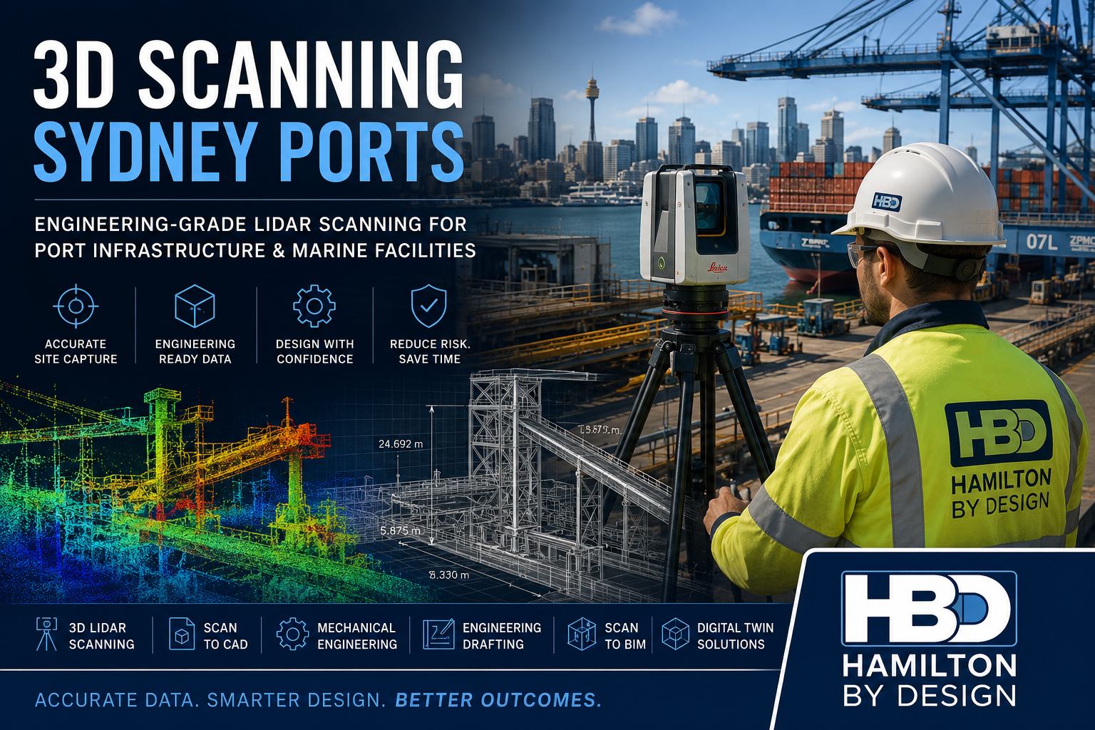
Hamilton By Design provides engineering-grade 3D scanning services for Sydney ports, delivering accurate reality capture data that supports mechanical engineering, drafting, structural design, Scan to CAD, asset management and brownfield infrastructure upgrades.
Using advanced terrestrial LiDAR scanning technology, we capture existing conditions quickly and safely, producing highly detailed point cloud data that can be converted into engineering deliverables including:
- 3D CAD Models
- AutoCAD Drawings
- General Arrangement Drawings
- Scan to BIM Models
- Structural Steel Models
- Mechanical Equipment Models
- Plant Layouts
- As-Built Documentation
- Digital Twin Models
Our engineering-led approach means the scan data is collected with the end engineering outcome in mind.
Why Sydney Ports Require Accurate 3D Scanning
Port infrastructure is continually evolving.
Container terminals, bulk handling facilities, fuel terminals, intermodal logistics hubs and marine infrastructure are frequently upgraded to accommodate increasing throughput, changing equipment requirements and modern safety standards.
One of the largest challenges facing engineering teams is obtaining reliable information about existing assets.
Common issues include:
- Outdated drawings
- Missing documentation
- Multiple undocumented modifications
- Restricted site access
- Shutdown constraints
- Safety requirements
- Complex pipework and structures
- Congested operating environments
Engineering-grade 3D scanning provides an accurate digital representation of existing conditions, allowing projects to progress with confidence.
Typical Sydney Port Infrastructure We Scan
Hamilton By Design regularly supports industrial and infrastructure environments where accurate site data is essential.
Typical assets include:
Container Terminals
- Container handling equipment
- Crane support structures
- Container storage areas
- Access roads
- Maintenance workshops
Bulk Materials Handling Facilities
- Conveyors
- Transfer stations
- Chutes
- Hoppers
- Loading facilities
- Stockpile infrastructure
Marine Infrastructure
- Wharves
- Jetties
- Berths
- Mooring structures
- Marine loading arms
- Access walkways
Industrial Port Assets
- Pipework systems
- Pump stations
- Mechanical equipment
- Structural steelwork
- Maintenance platforms
- Access structures
Engineering Applications of 3D Scanning in Sydney Ports
The value of a high-quality scan extends far beyond simple surveying.
Our clients use scan data to support a wide range of engineering activities.
Mechanical Engineering
3D scanning enables engineers to:
- Verify existing plant dimensions
- Design replacement equipment
- Check equipment clearances
- Plan shutdown activities
- Validate installation requirements
- Develop retrofit solutions
Mechanical engineering projects can proceed with confidence knowing the design is based on actual site conditions.
Scan to CAD
Point cloud data can be converted into:
- AutoCAD layouts
- Equipment drawings
- Structural steel models
- Plant layouts
- Detailed engineering documentation
This provides accurate engineering information where original drawings may no longer exist.
Brownfield Design Projects
Many Sydney port facilities have been operating for decades.
Over time, modifications can create significant discrepancies between drawings and reality.
3D scanning provides:
- Accurate as-built verification
- Clash detection
- Installation planning
- Design validation
- Reduced project risk
Shutdown Planning
Port shutdowns are expensive and highly planned events.
Accurate site data allows engineering teams to:
- Complete design work before site mobilisation
- Reduce field measurements
- Minimise rework
- Improve installation certainty
- Reduce shutdown durations
Benefits of Engineering-Grade LiDAR Scanning
Improved Accuracy
Laser scanning captures millions of measurement points, creating a highly accurate representation of existing conditions.
Reduced Site Visits
Comprehensive data capture reduces the need for repeat site attendance.
Improved Safety
Site exposure can be significantly reduced by using digital site information during design development.
Faster Project Delivery
Design teams can begin work sooner with accurate information available immediately after processing.
Better Project Outcomes
Improved information leads to improved engineering decisions.
Deliverables Available
Hamilton By Design can provide deliverables tailored to project requirements.
Common outputs include:
Point Cloud Deliverables
- E57
- RCP
- RCS
- LAS
- LGS
CAD Deliverables
- DWG
- DXF
- AutoCAD Models
- Layout Drawings
3D Models
- SolidWorks
- Inventor
- STEP
- SAT
- Parasolid
BIM Deliverables
- Revit Models
- Scan to BIM
- Asset Information Models
- Digital Twin Foundations
Why Choose Hamilton By Design?
Unlike survey-only providers, Hamilton By Design combines:
- Mechanical Engineering
- Engineering Drafting
- 3D LiDAR Scanning
- Scan to CAD
- Reverse Engineering
- Structural Detailing
- Industrial Design Support
This allows us to understand not only how to capture data but how that information will be used during engineering and construction activities.
Our team has supported projects throughout Australia across:
- Ports
- Mining
- Materials Handling
- Manufacturing
- Water Infrastructure
- Industrial Processing Plants
- Energy Facilities
Sydney Port Scanning Services
We support projects across:
- Port Botany
- White Bay
- Glebe Island
- Sydney Harbour Industrial Facilities
- Intermodal Freight Terminals
- Bulk Handling Facilities
- Container Terminals
- Marine Infrastructure Assets
We also support engineering projects throughout:
- Sydney
- Newcastle
- Central Coast
- Wollongong
- Regional NSW
- Australia-wide industrial facilities

Need a 3D Scanning Quote for a Sydney Port Project?
Whether you require accurate site capture for a brownfield upgrade, mechanical engineering project, shutdown planning exercise or Scan to CAD workflow, Hamilton By Design can provide engineering-grade LiDAR scanning services tailored to your project requirements.
Our services include:
✓ 3D LiDAR Scanning
✓ Terrestrial Laser Scanning
✓ Scan to CAD
✓ Mechanical Engineering
✓ Engineering Drafting
✓ Reverse Engineering
✓ Scan to BIM
✓ Asset Capture & Digital Twin Development
Contact Hamilton By Design today to discuss your Sydney port infrastructure project and obtain a tailored proposal.
Talk to Us – Contact Us
Our clients:


Frequently Asked Questions – 3D Scanning Sydney Ports
1. What is 3D scanning and how is it used in Sydney ports?
3D scanning uses LiDAR technology to capture millions of accurate measurement points from existing infrastructure. In Sydney ports, it is commonly used to document wharves, conveyors, ship loaders, pipelines, structural steelwork and terminal facilities for engineering and design projects.
2. What types of port infrastructure can be scanned?
Hamilton By Design can scan a wide range of port assets including:
- Container terminals
- Bulk materials handling facilities
- Conveyors
- Transfer stations
- Wharves and jetties
- Structural steelwork
- Pipework systems
- Pump stations
- Ship loading equipment
- Maintenance platforms
- Marine infrastructure
3. How accurate is LiDAR scanning for engineering projects?
Engineering-grade terrestrial LiDAR scanning typically achieves millimetre-level accuracy. Depending on project requirements, scan registration accuracy is commonly within ±5 mm to ±10 mm across large industrial facilities.
4. Can 3D scanning be completed while a port remains operational?
Yes. Most scanning projects can be undertaken during normal operations, planned maintenance periods or shutdowns. This minimises disruption while providing comprehensive site data for engineering teams.
5. What deliverables can be produced from a port scanning project?
Deliverables may include:
- E57 point clouds
- RCP and RCS files
- AutoCAD drawings
- 3D CAD models
- SolidWorks models
- STEP files
- General arrangement drawings
- Scan to BIM models
- As-built documentation
6. How does 3D scanning reduce engineering project risk?
Accurate site data helps eliminate assumptions and reduces the likelihood of design clashes, installation issues and costly rework. Engineers can design directly from verified site conditions rather than relying on outdated drawings.
7. Can laser scan data be converted into CAD drawings?
Yes. Hamilton By Design provides Scan to CAD services that convert point cloud data into:
- Floor plans
- Elevations
- Sections
- Equipment layouts
- Structural steel models
- Mechanical engineering drawings
8. What are the benefits of 3D scanning for port shutdown planning?
3D scanning allows engineering teams to:
- Capture existing conditions before shutdowns
- Reduce field measurements
- Improve installation planning
- Identify clashes early
- Minimise shutdown durations
- Improve project execution
9. Can 3D scanning support digital twin and BIM projects?
Yes. Laser scan data provides the foundation for digital twin and BIM workflows. Accurate models can be created for asset management, maintenance planning, future upgrades and operational optimisation.
10. Why choose Hamilton By Design for Sydney port scanning projects?
Hamilton By Design combines:
- Engineering-grade LiDAR scanning
- Mechanical engineering expertise
- Engineering drafting services
- Scan to CAD capability
- Reverse engineering experience
- Brownfield industrial project experience
Unlike survey-only providers, we understand how scan data is used throughout the engineering, design, fabrication and construction process, helping deliver practical outcomes for port infrastructure projects.