How AS 1100 and LiDAR Scanning Work Together: From Point Cloud to Compliant Drawings

Graduate engineer and senior engineer using LiDAR scanning on a Parramatta River construction site, reviewing point cloud data for accurate design.

AS 1100 & LiDAR Scanning: Compliant Engineering Drawings from Point Clouds

If youโ€™ve ever tried to update old plant drawings, verify a brownfield tie-in, or issue โ€œas-builtโ€ documentation after a shutdown, youโ€™ll know the pain: the site never matches the drawings, access is limited, and the smallest dimensional miss can cascade into rework, clashes, and schedule blowouts.

Thatโ€™s where engineering-grade LiDAR scanning and AS 1100 (the Australian Standard for technical drawing) make a powerful combination. LiDAR gives you truth data (reality capture), and AS 1100 gives you a shared language for turning that truth into clear, consistent, contract-ready documentation.

At Hamilton By Design, we treat scanning and drawing as one joined workflow: capture accurately โ†’ model intelligently โ†’ document to AS 1100 so everyone downstream can build, fabricate, install, and sign off with confidence.
(If you want to see the service side of this workflow, start here: https://www.hamiltonbydesign.com.au/home/engineering-services/3d-laser-scanning/3d-laser-scanning-for-engineering-projects/ and here: https://www.hamiltonbydesign.com.au/home/3d-lidar-scanning-digital-quality-assurance/)


What AS 1100 actually โ€œdoesโ€ in the real world

AS 1100 standardises the way we communicate engineering information through drawings: layout, line types, projection methods, dimensioning rules, tolerancing conventions, symbols, notes, and drawing presentation.

In practice, AS 1100 helps you answer questions like:

  • Which edges are visible vs hidden? (line conventions)
  • How are views arranged and interpreted? (projection and view layout)
  • How do we dimension so the fabricator canโ€™t misread it? (dimensioning rules)
  • How do we document what matters vs whatโ€™s โ€œreference onlyโ€? (notes and drawing hierarchy)
  • How do we keep drawing sets consistent across multiple contributors? (formatting + standards)

That consistency is exactly whatโ€™s needed after a scanโ€”because point clouds are rich, but theyโ€™re not automatically โ€œcommunicableโ€ in the way a compliant drawing set is.


What LiDAR scanning adds that drawings alone canโ€™t

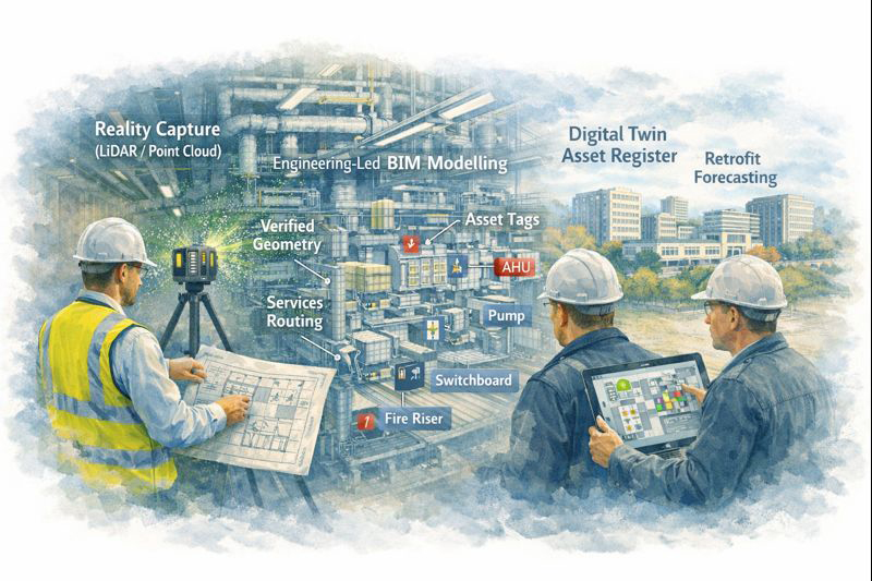
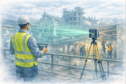
A LiDAR scanner captures millions (often billions) of spatial points that represent real surfacesโ€”steel, concrete, pipe, equipment, structureโ€”creating a point cloud that can be registered into a unified coordinate system.

Dassault Systรจmes SolidWorks Professional Weldments certification badge

In the engineering context, the big advantages are:

  • Speed: capture complex geometry quickly, often with minimal disruption
  • Coverage: see whatโ€™s hard to measure with tape/total station (overhead services, congested pipe racks, odd geometry)
  • Context: capture โ€œeverything,โ€ not just what someone remembered to measure
  • Traceability: you can always โ€œgo backโ€ to the scan for verification and queries
  • Clash prevention: scan-to-CAD makes it far easier to design upgrades that actually fit

But hereโ€™s the key: a point cloud isnโ€™t a deliverable most trades can fabricate from directly.
Thatโ€™s why AS 1100 becomes the bridge between capture and construction.


The combined workflow: Point cloud โ†’ model โ†’ AS 1100 drawings

1) Capture the site as it really is

We scan the area of interest and register scans into a coordinated dataset. This becomes the base truth for everything that follows. If the project is shutdown-driven, we plan scanning around access windows and risk controls (often capturing adjacent tie-in zones too, because โ€œnearbyโ€ services are where surprises live).

2) Establish intent: โ€œWhat are we delivering?โ€

Not every project needs the same output. Typical outcomes include:

  • As-built drawings for existing assets
  • As-found models to support new design work
  • Dimensional verification for fit-up and prefabrication
  • Digital QA against design intent (scan-vs-model comparison)

Hamilton By Design leans hard into this QA piece where it matters mostโ€”because catching a misalignment early is cheaper than discovering it on install day.
More on the QA angle here: https://www.hamiltonbydesign.com.au/home/3d-lidar-scanning-digital-quality-assurance/

3) Convert scan data into engineering geometry (as much as needed)

Sometimes the best output is a controlled 3D model (plant layout, pipe spools, structural members). Other times the project is best served by 2D drawings extracted from a model.

Weโ€™ll typically create:

  • key datums and grids
  • primary steel / structure
  • equipment envelopes and critical interfaces
  • piping runs and connection points (where relevant)
  • floor levels, platforms, access constraints, clearance zones

4) Document to AS 1100 so the drawing set is unambiguous

This is where AS 1100 shines. We turn geometry into drawings that read cleanly and consistently across teams.

That includes:

  • correct view layouts (plan/elevation/section/detail)
  • line conventions (visible/hidden/centre lines)
  • clear dimensioning strategy (functional dims first)
  • consistent annotation and notes
  • drawing borders, title blocks, revision control, and drawing register discipline

In short: LiDAR gives accuracy, AS 1100 gives clarity.


Where AS 1100 + LiDAR scanning delivers immediate value

Brownfield upgrades and tie-ins

Tie-ins fail when the โ€œas-builtโ€ condition is wrong. A scan gives you real geometry; AS 1100 drawings package it so designers, fabricators, and installers share the same reference. This is especially useful when multiple contractors are interfacing.

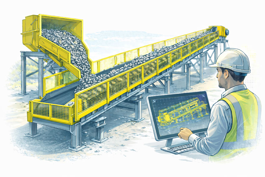
Fabrication and spool accuracy

If youโ€™re fabricating offsite (pipe spools, platform steel, handrail sections, ducting), you need dependable dimensions and an agreed drawing language. Scan-derived models support accuracy; AS 1100 drawings support fabrication interpretation and QA sign-off.

Shutdown planning and constructability

A point cloud is a brilliant planning toolโ€”access routes, crane clearances, removal paths, temporary works, and โ€œwhatโ€™s in the way.โ€ But shutdown packages still need compliant drawings for permits, isolations, install workpacks, and handover packs. AS 1100 keeps those packages readable and defensible.

Verification and โ€œwhat changed?โ€

Sites evolve. A scan provides a timestamped snapshot. Drawings updated to AS 1100 become the controlled record: what was there, what was installed, and what the current state is. That matters for maintenance, safety, and future projects.


Practical example: Turning a congested pipe rack into a buildable upgrade

Imagine youโ€™re adding a new line through an existing pipe rack:

  1. Scan the rack to capture all existing services, supports, cable trays, and steel
  2. Model critical geometry (existing plus proposed) to check routing and supports
  3. Clash check before fabrication begins
  4. Issue AS 1100 drawings for:
    • support details
    • spool isometrics (if applicable)
    • arrangement drawings showing tie-in locations
    • sections through congestion zones
    • installation notes and tolerances where appropriate
  5. Verify post-install with a follow-up scan if required for QA/closeout

Thatโ€™s the โ€œwork togetherโ€ part: the scan stops guesswork, and AS 1100 stops misinterpretation.


Common mistakes when scanning isnโ€™t tied back to AS 1100

  • Delivering point clouds without a drawing strategy (stakeholders canโ€™t use them effectively)
  • Over-modelling everything (time is spent modelling non-critical items instead of delivering useful documentation)
  • Unclear dimensioning (scan accuracy is wasted if dimensions are presented ambiguously)
  • No controlled datums (people argue about โ€œwhere zero isโ€ and models drift between disciplines)
  • Weak revision control (the drawing set becomes untrustworthy fast)

A standards-led drawing approach prevents most of these.


How we approach it at Hamilton By Design

Our angle is simple: engineering-led scanningโ€”not scanning for its own sake.

  • We capture reality with LiDAR.
  • We translate it into the level of model detail the project actually needs.
  • We document outputs with the discipline and consistency expected in Australian engineering environments.

If you want the practical breakdown of how we do scan capture and modelling for projects, start here:
https://www.hamiltonbydesign.com.au/home/engineering-services/3d-laser-scanning/3d-laser-scanning-for-engineering-projects/

And if your priority is dimensional verification, fit-up confidence, or proving compliance against design intent, this page explains our digital QA approach:
https://www.hamiltonbydesign.com.au/home/3d-lidar-scanning-digital-quality-assurance/


Hamilton By Design logo displayed on a blue tilted rectangle with a grey gradient background

Closing thought: accuracy is only valuable if itโ€™s understandable

LiDAR scanning can deliver millimetre-grade spatial truth. But in real projects, truth still has to travel through peopleโ€”engineers, drafters, fabricators, installers, supervisors, and asset owners.

AS 1100 makes that truth readable.
LiDAR makes it reliable.

Together, they turn messy real-world geometry into clear, controlled documentation that supports safer installs, faster shutdowns, and fewer surprises.

Name
Would you like us to arrange a phone consultation for you?
Address

3D Scanning in Greater Sydney NSW: From Point Cloud to BIM and Digital Twins for Smarter Projects

Engineers reviewing industrial design improvements in a mining fabrication workshop using engineering controls to reduce safety risks

3D Scanning in Greater Sydney NSW | Point Cloud to BIM & Digital Twins for Smarter Projects

Across Greater Sydney โ€” including industrial hubs like Blacktown โ€” asset owners and project teams are under increasing pressure to deliver upgrades, expansions, and maintenance projects with less downtime and lower risk. In congested brownfield environments, the biggest challenge is often not design โ€” it is knowing exactly what already exists on site.

This is where engineering-grade 3D laser scanning and point cloud to BIM workflows are transforming the way projects are planned and delivered across NSW.

At Hamilton By Design, we support industrial and infrastructure projects by converting accurate site data into practical engineering models that improve project certainty from concept through to construction.


From point cloud to digital twin for lifecycle management of Sydney industrial and precinct assets

Why Accurate Site Data Matters in Greater Sydney

Many industrial facilities across Greater Sydney have evolved over decades. Services are added, conveyors rerouted, platforms extended, and temporary fixes become permanent. Unfortunately, drawings are rarely updated to reflect these changes.

For project managers, this creates risks such as:

  • Late discovery of clashes during installation
  • Unplanned scope changes and shutdown delays
  • Increased safety exposure during site rework
  • Cost overruns due to fabrication errors

Without accurate as-built data, project planning becomes reactive instead of proactive.

From 3D Scanning to Point Cloud to BIM

Using engineering-grade LiDAR scanners, we capture millions of spatial data points across entire facilities, producing highly accurate point clouds that represent the real-world geometry of structures, conveyors, services, and equipment.

These point clouds are then converted into:

  • BIM-ready 3D models
  • Fabrication-ready CAD geometry
  • Digital twins for ongoing asset management

This point cloud to BIM process allows project teams to design, coordinate, and review upgrades in a digital environment before any physical work begins.

For project management, this means fewer surprises and far better control over scope, schedule, and cost.

Digital Twin Creation for Ongoing Asset Management

Beyond individual projects, many asset owners in NSW are now adopting digital twins to manage facilities across their full lifecycle.

A digital twin created from accurate scan data allows teams to:

  • Visualise plant layouts remotely
  • Plan future upgrades with confidence
  • Improve maintenance access planning
  • Support safety reviews and training

In multi-site operations across Greater Sydney, digital twins also support consistent engineering standards and faster project scoping.

Rather than starting from scratch for every shutdown, project teams can build on a continually updated digital asset model.


Bulk materials conveyor with compliant safety guarding at the hopper, tail end, and along the conveyor, shown with an engineer reviewing guarding design drawings.

Supporting Conveyor Design in Brownfield Environments

Conveyor systems remain critical to manufacturing, logistics, waste processing, and bulk materials handling facilities across Sydneyโ€™s western suburbs, including Blacktown and surrounding industrial precincts.

When conveyors are upgraded or rerouted, spatial constraints often drive:

  • Poor maintenance access
  • Compromised guarding
  • Clashes with services and structures

Scan-based conveyor modelling allows engineers to:

  • Verify belt paths, transfer points, and head drives
  • Design guarding that fits existing structures
  • Improve access platforms and walkways
  • Reduce installation time during shutdowns

For project managers, this directly translates into reduced safety risk and fewer installation delays.

Project Management Benefits of 3D Scanning

From a project delivery perspective, engineering-grade scanning supports:

  • More accurate scope definition
  • Better contractor coordination
  • Improved constructability reviews
  • Reduced variation claims
  • Safer installation planning

When all stakeholders are working from the same verified model, communication improves and decision-making becomes faster and more reliable.

This is particularly valuable on fast-tracked shutdown projects where every hour of downtime has a production cost.

Local Support Across Greater Sydney NSW

Hamilton By Design provides on-site 3D scanning, BIM modelling, and mechanical engineering support across Greater Sydney, including:

  • Blacktown
  • Western Sydney industrial precincts
  • Central Sydney infrastructure sites
  • Logistics and manufacturing facilities across NSW

As an engineering-led business, we integrate scanning directly into design, drafting, and fabrication support โ€” ensuring that digital models deliver practical, buildable outcomes.

Our focus is not just capturing data, but turning it into engineering solutions that reduce risk and improve project performance.

Turning Reality Capture into Project Confidence

Whether planning a conveyor upgrade, plant expansion, or long-term asset management strategy, accurate site data is the foundation of successful delivery.

By moving from point cloud to BIM and digital twins, project teams across Greater Sydney are gaining better visibility, stronger risk control, and far greater confidence in their project outcomes.


Name
Would you like us to arrange a phone consultation for you?
Address

Reality Capture for Live or Operational Sites (High-Risk Environments)

Engineer performing LiDAR scanning on live construction site with BIM model overlay for clash-free installation

Reality Capture for Live Sites Sydney | 3D Scanning Without Shutdowns

Keep Sydney Projects Running: Accurate Reality Capture Without Shutdowns

Many projects across Greater Sydney and the Central Coast take place in live, operational environments โ€” hospitals, shopping centres, CBD offices, industrial plants, transport facilities, and heritage buildings โ€” where shutdowns are either impossible or extremely costly.

At Hamilton By Design, we provide engineer-led reality capture and 3D scanning services that allow accurate measurement, modelling, and verification without interrupting operations. Our approach supports safe access, staged construction, and clash-free installation โ€” keeping your project moving while reducing risk, rework, and variations.


The Challenge of Working in Live Environments

Builders, project managers, and facilities teams face real risks when upgrading or modifying operational sites:

  • Buildings that have moved over time, with visible cracking or deformation
  • Changes in soil conditions or legacy engineering affecting structure and services
  • Outdated or unreliable drawings that no longer reflect site conditions
  • Unexpected clashes once walls, ceilings, or plant rooms are opened
  • High costs from rework and contract variations
  • Safety risks from confined spaces, working at heights, or restricted access zones

Relying on manual measurement or assumptions in these environments increases both programme risk and safety exposure.


Reality capture of operational industrial facility using 3D laser scanning without site shutdown

Non-Contact Measurement for High-Risk and Restricted Sites

Our reality capture solutions use non-contact laser scanning and LiDAR technology to safely collect accurate site data, even in difficult or restricted environments.

This allows us to capture:

  • Services above ceilings and within plant rooms
  • Structural elements and building geometry
  • Equipment clearances and access constraints
  • Deformed or out-of-plumb structures

All while minimising disruption to occupants and operations.

Safety and Access Benefits

  • Reduced need for working at heights
  • Faster site presence and data capture
  • Minimal interference with daily operations
  • Scanning possible from walkways or public-access areas
  • Fewer permits, isolations, and shutdown windows required

This makes scanning ideal for live hospitals, retail centres, offices, and industrial facilities where safety and continuity are critical.


Supporting Staged Construction and Live Upgrades

Live environments rarely allow full shutdowns. Our reality capture workflows are designed to support:

  • Staged construction programs
  • Progressive installation of services
  • Ongoing refurbishment works
  • Verification before each construction phase

We can also perform repeat scanning to monitor:

  • Structural movement
  • Progressive cracking
  • Deformation of walls, floors, or structural members

This is especially valuable where movement, settlement, or ageing infrastructure is a concern.


Practical Outcomes for Builders and Project Teams

Our scan data is not just collected โ€” it is engineered into practical construction deliverables that support real project decisions.

Clients use our reality capture outputs for:

  • Design of new mechanical, electrical, and plumbing services
  • Accurate as-built verification prior to fabrication
  • Set-out and coordination models for installation
  • Clash detection before construction begins
  • Monitoring movement or deformation over time

This reduces uncertainty, improves coordination between trades, and significantly lowers the risk of costly on-site surprises.


Construction-Ready Deliverables

We provide data in formats that integrate directly into your existing workflows and design platforms:

  • Point clouds (RCP / E57)
  • Revit models
  • AutoCAD files
  • SolidWorks models
  • 2D drawings (plans, sections, elevations)
  • Clash-ready coordination models

Our focus is on delivering usable, construction-ready information, not just raw scan files.


Engineer-Led Reality Capture โ€” Not Just Scanning

Hamilton By Design is not a scanning-only provider. We deliver end-to-end technical services, allowing us to support projects from concept through to installation.

Our integrated capabilities include:

  • Reality capture and 3D scanning
  • Mechanical engineering
  • Systems management
  • Project management
  • Machining and fabrication support

Because our work is engineer-led, scan data is interpreted with constructability, tolerances, and installation constraints in mind โ€” not simply converted into drawings by offshore drafting teams.

This means better decisions, fewer assumptions, and stronger outcomes on site.


Supporting Greater Sydney and the Central Coast

We regularly support projects across:

  • Sydney CBD and metropolitan areas
  • Major commercial and retail precincts
  • Health and education facilities
  • Industrial and processing plants
  • Infrastructure and heritage assets
  • Central Coast commercial and industrial sites

Our local presence allows efficient mobilisation and ongoing project support throughout staged works.


Hamilton By Design logo displayed on a blue tilted rectangle with a grey gradient background

Reduce Risk. Avoid Shutdowns. Build With Confidence.

Reality capture is no longer just a documentation tool โ€” it is a risk management strategy for live environments.

By capturing what is truly on site before construction begins, you can:

  • Prevent clashes and redesign
  • Reduce variations and rework
  • Improve safety planning
  • Protect programme and operational continuity

Arrange a Phone Consultation

If you are planning works in a live or high-risk environment and need reliable site data without shutdowns:

Please fill out the form below to arrange a phone consultation.

Weโ€™ll discuss your site conditions, construction staging, and deliverable requirements, and recommend the most effective reality capture approach for your project.

Name
Would you like us to arrange a phone consultation for you?
Address

Establish a Baseline for Wall Movement in Your Property

Wall Crack Monitoring & Structural Movement Baseline Scans | NSW

Know When Cracks Are Cosmetic โ€” and When Theyโ€™re Not

Cracks in walls are common, but not all cracks are harmless. The real risk isnโ€™t just that a crack exists โ€” itโ€™s how fast itโ€™s changing. Without a baseline, thereโ€™s no reliable way to tell whether your property is stable or slowly moving toward serious structural damage.

Thatโ€™s where our Property Wall Movement Baseline Scan comes in.


What Is a Baseline Scan?

A baseline scan is a highโ€‘accuracy digital survey of your property taken at the moment cracking is first observed. Using precision scanning technology, we capture:

  • Wall alignment and deflection
  • Crack location, length, and width
  • Floor and ceiling reference planes
  • Structural reference points across the building

This scan becomes your timeโ€‘zero reference point โ€” a measurable snapshot of your buildingโ€™s condition today.


Why a Baseline Matters

Without a baseline:

  • Cracks are judged visually (subjective and unreliable)
  • Engineers lack historical movement data
  • Insurance claims become harder to substantiate
  • Small issues can quietly become major repairs

With a baseline:

  • Movement can be quantified in millimetres
  • Crack growth rates can be tracked over time
  • Engineers can make confident, dataโ€‘driven decisions
  • You gain early warning before damage becomes critical

How the Process Works

1. Initial Scan

We perform a nonโ€‘invasive scan of affected areas and key structural zones to establish your baseline condition.

2. Data Archiving

All scan data is securely stored and referenced to fixed control points within your property.

3. Followโ€‘Up Scans

Repeat scans (3, 6, or 12 months later) are compared against the baseline to calculate:

  • Crack propagation rate
  • Wall movement direction
  • Structural settlement or heave

4. Clear Reporting

You receive a clear, easyโ€‘toโ€‘understand report showing:

  • Measured movement (if any)
  • Rate of change over time
  • Professional recommendations

Ideal For

  • Homeowners noticing new or worsening cracks
  • Properties affected by reactive soils or subsidence
  • Buildings near excavation or construction activity
  • Insurance documentation and dispute resolution
  • Engineers requiring longโ€‘term movement data

Early Data Saves Money

Monitoring movement early often means minor intervention instead of major reconstruction. A baseline scan gives you certainty, evidence, and peace of mind.

If nothing is moving โ€” youโ€™ll know.
If something is โ€” youโ€™ll know before itโ€™s too late.


Hamilton By Design logo displayed on a blue tilted rectangle with a grey gradient background

Book a Baseline Scan

If youโ€™ve noticed cracking, now is the right time to act.

Contact us today to establish your propertyโ€™s movement baseline and protect its longโ€‘term structural integrity.


Precision data. Clear answers. Smarter decisions.

Name
Would you like us to arrange a phone consultation for you?
Address