


Engineering-Grade 3D LiDAR Scanning for Industrial & Mining Assets
Industrial and mining facilities rarely match their original drawings. Over years of operation, shutdown upgrades, temporary works, and undocumented modifications, the true as-built condition of assets becomes uncertain.
Hamilton By Design provides engineering-grade 3D LiDAR scanning for industrial and mining environments — delivering engineered as-built data that can be confidently used for mechanical design, structural verification, compliance assessment, and fabrication-ready documentation.
This is not scanning for visualisation.
This is scanning for engineering decisions.
Why Conventional 3D Scanning Fails in Industrial Environments
Many organisations already have laser scans, yet still experience:
- Fabrication that does not fit on site
- Structural clashes discovered during installation
- Rework during shutdowns
- Safety and compliance gaps
- Models that look accurate but cannot be engineered
These failures occur because most scans are captured without engineering context.
Common issues include:
- No understanding of load paths or structural behaviour
- No allowance for deformation, wear, or misalignment
- Survey-grade outputs delivered without design intent
- Point clouds handed over with no accountability for engineering use
In industrial environments, data without interpretation introduces risk.
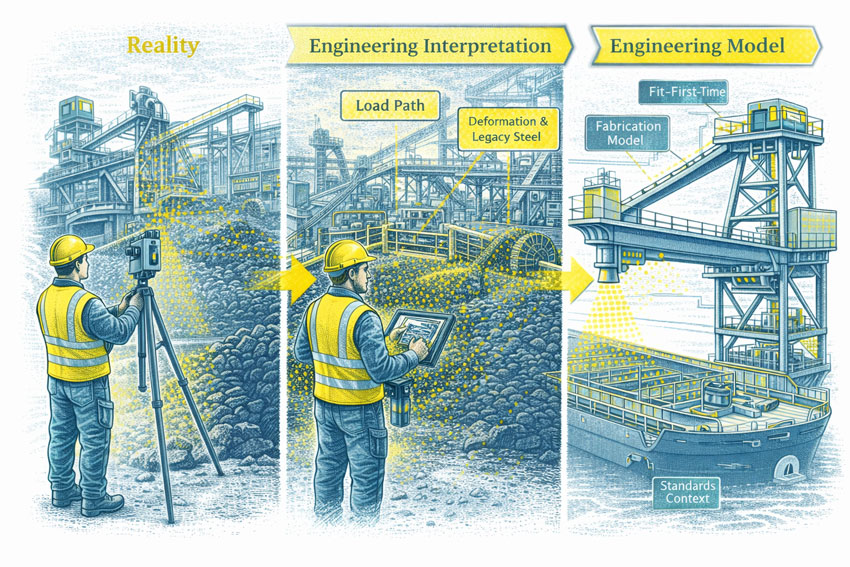
What “Engineering-Grade” LiDAR Scanning Actually Means
Engineering-grade LiDAR scanning integrates engineering judgement into every stage of the capture-to-model workflow.
Accuracy Aligned to Engineering Use
- Local accuracy suitable for mechanical interfaces
- Controlled registration focused on critical geometry
- Tolerances aligned with fabrication and installation requirements
Engineering Interpretation of the Point Cloud
- Identification of structural versus non-structural elements
- Recognition of deformation, wear, and legacy modifications
- Assessment of which geometry can be relied upon for design
Design-Ready Outputs
- SolidWorks-based 3D CAD models
- Interfaces defined for new works and retrofits
- Geometry suitable for detailing, load checks, and verification
A point cloud alone does not provide engineering certainty.
Engineering interpretation does.
Standards, Compliance, and Risk Context
Industrial assets are governed by Australian Standards, safety legislation, and duty-of-care obligations. Accurate as-built information is often the starting point for demonstrating compliance and reducing risk.
Engineering-grade LiDAR scanning is commonly used to support:
- Conveyor safety and guarding compliance
- Bulk solids handling and load assessment
- Structural steel verification
- Mechanical fit-up and clearance checks
- Plant modifications and upgrades
Our Engineer-Led LiDAR Scanning Workflow
Our workflow is deliberately engineer-led, ensuring accountability from site capture through to fabrication-ready outputs.
1. Engineering-Driven Site Capture
Scanning is planned around:
- Known and suspected modification scopes
- Interfaces critical to new works
- Areas of structural or compliance risk
- Access and shutdown constraints
2. Controlled Point-Cloud Processing
- Registration verified against engineering requirements
- Validation of critical geometry
- Noise reduction aligned to modelling intent
3. Engineering Interpretation
- Identification of true load-bearing elements
- Recognition of temporary and legacy works
- Assessment of deformation and alignment
4. 3D CAD Modelling (SolidWorks)
- As-built geometry modelled to engineering tolerances
- Interfaces defined for fabrication and installation
- Models structured for downstream design and detailing
5. Engineering Verification (Where Required)
- Mechanical and structural checks
- Load paths and operational constraints reviewed
- Design validation prior to fabrication
6. Fabrication-Ready Deliverables
- General arrangement drawings
- Detailed fabrication drawings
- Bills of materials and installation references
This single-source workflow removes the hand-offs that typically lead to rework.
Typical Assets We Scan and Model
Engineering-grade LiDAR scanning is routinely applied to:
- Conveyors and transfer stations
- Hoppers, bins, and silos
- Chutes and wear liners
- Pipe racks and services
- Platforms, walkways, and mezzanines
- Structural steel in brownfield facilities
- Processing plant and bulk materials systems
These assets are rarely square, level, or unchanged — which is precisely why scanning must be engineered.
Brownfield and Live-Site Environments
LiDAR scanning is particularly valuable where:
- Assets must remain operational
- Access is restricted or hazardous
- Drawings are incomplete or unreliable
- Traditional measurement introduces safety risk
Non-contact scanning allows accurate capture without interfering with operations, while still delivering engineering-usable data.
Supporting “Fit-First-Time” Outcomes
The real cost of poor as-built information is rarely the scan itself. It is reflected in:
- Fabrication rework
- Installation delays
- Extended shutdowns
- Safety exposure
- Loss of confidence in engineering documentation
Engineering-grade scanning reduces these risks by ensuring:
- Interfaces are verified before fabrication
- Design assumptions are checked
- Construction teams receive buildable information
This is how digital capture translates into physical certainty.
Where This Service Is Delivered
Hamilton By Design delivers engineering-grade LiDAR scanning across metropolitan, regional, and remote industrial locations throughout Australia.
A dedicated Sydney-focused delivery page builds on this engineering framework to address the specific challenges of brownfield, compliance-driven assets in NSW.

Why Hamilton By Design
Clients engage Hamilton By Design because we provide:
- Engineer-led scanning and modelling
- Mechanical and structural engineering integration
- Single-source accountability
- No scanning-only hand-offs
- Deliverables designed for fabrication and construction
We do not sell point clouds.
We deliver engineering-usable truth.
Our clients


