

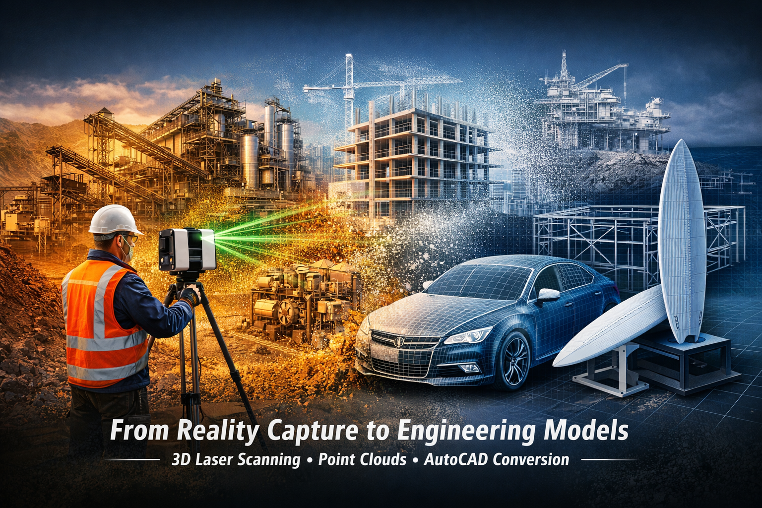
Turning Laser Scan Data into Engineering CAD Models
Modern engineering projects often begin with 3D laser scanning or LiDAR scanning, capturing millions of measured data points representing real-world infrastructure. These measurements form a point cloud, which accurately represents existing plant, structures, and equipment.
However, raw point cloud data alone is not typically usable for engineering design. Engineers require structured CAD geometry and drawings to modify infrastructure, plan upgrades, or integrate new equipment.
Hamilton By Design converts point cloud scan data into AutoCAD models and engineering drawings, providing accurate digital representations of existing facilities that engineers can confidently design around.
Engineering Services Supported by Scan to CAD
Point cloud modelling is part of the broader engineering services provided by Hamilton By Design, supporting industries such as mining, industrial processing, infrastructure and manufacturing.
Learn more about our engineering capabilities:
By combining engineering design expertise with advanced 3D scanning technology, Hamilton By Design delivers accurate models that support plant upgrades, equipment integration and retrofit design.
What is a Point Cloud?
A point cloud is a digital dataset created by 3D laser scanning (LiDAR). A scanner measures millions of points across surfaces, capturing the true geometry of buildings, machinery and infrastructure.
The result is a highly detailed digital representation of the scanned environment.
Hamilton By Design specialises in capturing these datasets using engineering-grade scanning equipment.
Learn more about the scanning process:
Converting Point Clouds into AutoCAD Models
Once captured, the point cloud data is processed and interpreted to create structured engineering models.
Typical deliverables include:
• AutoCAD 2D layout drawings
• 3D CAD plant models
• structural steel models
• equipment layouts
• pipework routing models
• as-built documentation
These models provide engineers with a reliable digital reference when designing plant modifications or infrastructure upgrades.
Typical Scan to CAD Workflow
Hamilton By Design follows a structured engineering workflow:
1. Site Laser Scanning
Existing infrastructure is captured using high-resolution LiDAR scanners.
2. Point Cloud Registration
Multiple scans are combined into a unified coordinate system.
3. Data Processing
The dataset is cleaned and prepared for modelling.
4. CAD Model Creation
Engineering geometry is created within AutoCAD or other CAD platforms.
5. Engineering Deliverables
The model is used to produce drawings, layouts, and design documentation.
For national scanning capability see:
Applications in Mining and Industrial Facilities
Point cloud to AutoCAD conversion is widely used for brownfield engineering projects where existing conditions must be accurately captured.
Typical applications include:
Mining Infrastructure
• conveyors
• transfer chutes
• crushers and screening plants
• stockpile systems
Industrial Processing Plants
• pump stations
• piping systems
• mechanical equipment layouts
• structural frameworks
Infrastructure and Buildings
• plant rooms
• service corridors
• retrofit projects
• structural documentation
Accurate scan-to-CAD modelling significantly reduces the risk of design clashes and installation issues during construction.
Reverse Engineering from Scan Data
Laser scanning can also support reverse engineering projects, where physical objects are converted into digital engineering models.
Hamilton By Design provides reverse engineering services for both industrial equipment and complex geometries.
Learn more about reverse engineering:
Example application:
3D Laser Scanning and Modelling Across Australia
Hamilton By Design provides 3D scanning and point cloud modelling services across Australia, supporting engineering projects in:
• mining
• industrial processing
• infrastructure
• construction
• manufacturing
Our integrated approach combines reality capture with engineering modelling, enabling accurate design and planning for complex facilities.
More about our national scanning services:
From Reality Capture to Engineering Design
3D laser scanning provides a precise digital record of existing infrastructure. Converting this information into AutoCAD models allows engineers to confidently design plant upgrades, modifications and new installations.
Hamilton By Design bridges the gap between reality capture and engineering design, transforming point cloud data into practical engineering models.
