More Reading – Engineering Articles and Technical Resources

Engineer using a laser scanner capturing an industrial facility, converting scan data into a point cloud and engineering CAD model.

At Hamilton By Design, we regularly publish articles about engineering workflows, plant upgrades, LiDAR scanning, mechanical design, and industrial infrastructure.

We also contribute to technical discussions and engineering blogs that explore topics such as point cloud modelling, SolidWorks design, pipework detailing, and mining infrastructure upgrades.

This page provides a collection of additional technical reading and external resources related to engineering design and digital engineering workflows.

These articles complement the work we do at Hamilton By Design and may be useful for engineers, project managers, designers, and plant operators involved in industrial and mining infrastructure projects.


Industrial engineer operating a LiDAR laser scanner capturing high-accuracy point cloud data of a processing plant for engineering design and infrastructure upgrades.

Pipework Detailing and SolidWorks Design

One area where modern digital workflows are particularly valuable is pipework detailing and fabrication drawing development.

By combining LiDAR scanning with SolidWorks modelling, engineers can capture the true geometry of existing plant infrastructure and develop accurate pipe spool drawings for fabrication and installation.

The following article explores how laser scanning data can be used to support this workflow:

From Laser Scan to Pipe Spool Drawings – Using SolidWorks and LiDAR Data for Accurate Pipework Design

https://pipeworkdetailing.blogspot.com/2026/03/from-laser-scan-to-pipe-spool-drawings.html

This article discusses how engineering teams can move from capturing plant geometry with LiDAR scanning through to generating pipe spool drawings for fabrication.


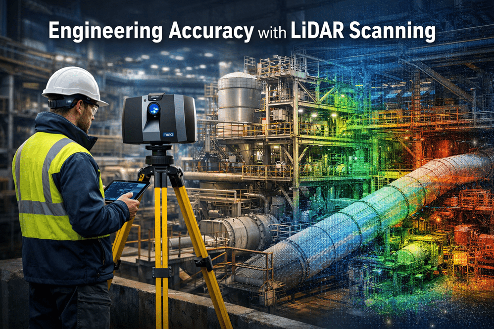
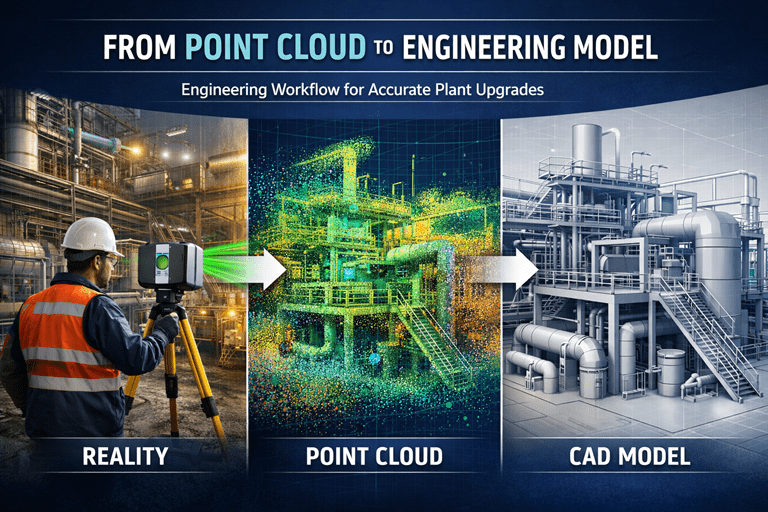
LiDAR Scanning and Engineering Design Workflows

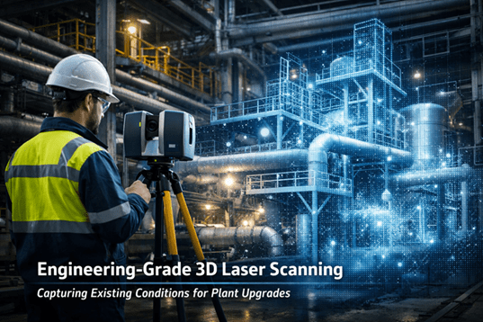
Laser scanning is increasingly used across industrial and mining projects to capture existing plant conditions before upgrades or modifications begin.

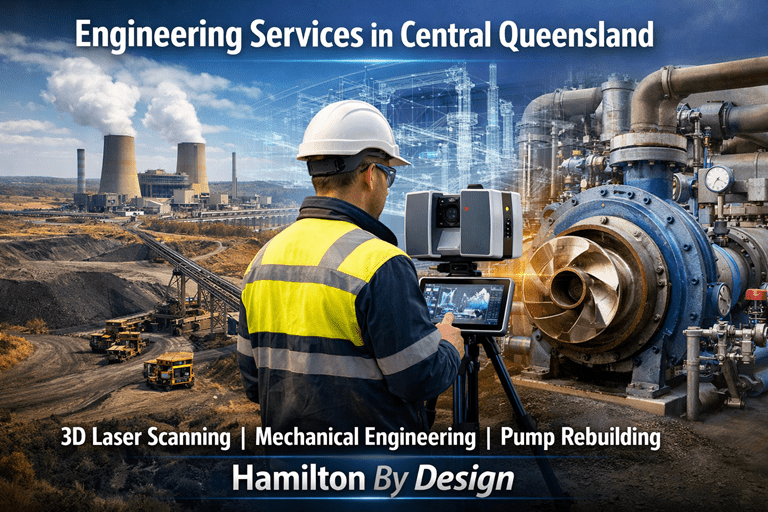
At Hamilton By Design we use engineering-grade LiDAR scanning to support:

• Mining infrastructure upgrades
• Industrial plant modifications
• Mechanical equipment installations
• Structural steel design
• Pipework routing and detailing
• Shutdown engineering projects

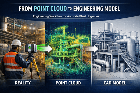
By converting scan data into engineering models, design teams can work directly against the true geometry of the plant environment.


Related Articles on the Hamilton By Design Website

You may also find the following articles useful:

Engineering Grade 3D Laser Scanning for Mining and Industrial Projects
https://www.hamiltonbydesign.com.au/home/engineering-grade-3d-laser-scanning-mining-industrial/

3D Laser Scanning Across Australia
https://www.hamiltonbydesign.com.au/home/engineering-services/3d-laser-scanning/3d-laser-scanning-across-australia/

3D Laser Scanning for Mining Plant Upgrades
https://www.hamiltonbydesign.com.au/engineering-grade-3d-laser-scanning-mining-plant-upgrades/

3D Laser Scanning for Mining Shutdown Projects
https://www.hamiltonbydesign.com.au/3d-laser-scanning-mining-shutdowns/

Capture Existing Conditions Before Plant Upgrades
https://www.hamiltonbydesign.com.au/capture-existing-conditions-before-plant-upgrades/

Point Cloud to Engineering Model Workflow
https://www.hamiltonbydesign.com.au/point-cloud-to-engineering-model-workflow/


Why We Share Additional Engineering Reading

Engineering projects often benefit from a combination of practical field knowledge, digital modelling workflows, and collaboration across the engineering community.

By sharing additional articles and resources, we hope to contribute to ongoing discussions about:

• Engineering measurement and accuracy
• Digital engineering workflows
• Mining infrastructure design
• Mechanical and structural modelling
• Industrial plant upgrades

If you are interested in discussing engineering-grade 3D laser scanning, mechanical engineering design, or infrastructure upgrades, please feel free to contact Hamilton By Design.

Name
Would you like us to arrange a phone consultation for you?
Address

Accuracy of LiDAR Scanning for Engineering Applications

Industrial engineer operating a LiDAR laser scanner capturing high-accuracy point cloud data of a processing plant for engineering design and infrastructure upgrades.

Modern engineering projects increasingly rely on accurate digital representations of existing infrastructure before design, fabrication, or modification begins. One of the most powerful technologies enabling this is LiDAR scanning (Light Detection and Ranging).

At Hamilton By Design, LiDAR scanning is used to capture engineering-grade point cloud data of industrial facilities, mining infrastructure, processing plants, and mechanical systems across Australia.

Understanding the accuracy of LiDAR scanning is essential for engineers, project managers, and asset owners when planning upgrades or modifications to existing facilities.


LiDAR scanning of industrial infrastructure with a 3D point cloud overlay showing engineering-grade measurement accuracy.

What is LiDAR Scanning?

LiDAR scanning works by emitting thousands of laser pulses per second. These pulses strike surrounding surfaces and return to the scanner, allowing precise calculation of distance.

The result is a dense three-dimensional point cloud that captures the exact geometry of an environment.

This digital dataset can then be used for:

• Engineering modelling
• Plant layout verification
• Clash detection
• Structural analysis
• Reverse engineering
• Retrofit design

At Hamilton By Design, these datasets are commonly converted into engineering models and SolidWorks design geometry using our established workflow.

Learn more about this process here:

Point Cloud to Engineering Model Workflow
https://www.hamiltonbydesign.com.au/point-cloud-to-engineering-model-workflow/


Typical Accuracy of Engineering LiDAR Scanning

The accuracy of LiDAR scanning depends on several factors including the scanner type, range to the object, scanning environment, and control methodology.

Typical engineering-grade terrestrial LiDAR systems achieve:

ParameterTypical Accuracy
Scanner measurement accuracy±1 mm to ±3 mm
Registered scan network accuracy±2 mm to ±6 mm
Large plant scan accuracy±5 mm to ±10 mm

For most industrial engineering applications, this level of accuracy is more than sufficient to support:

• Structural steel modifications
• Pipework routing and tie-ins
• Mechanical equipment installation
• Conveyor and materials handling upgrades
• Plant shutdown engineering works


Factors That Affect LiDAR Accuracy

Although LiDAR scanning can achieve extremely high accuracy, several practical factors influence final results.

Scan Resolution

Higher resolution scanning increases the number of measured points and improves detail, but also increases processing time and file size.

Distance to Target

Accuracy decreases slightly as the distance between the scanner and the object increases. Industrial scanning programs typically maintain distances between 5–40 metres.

Scan Registration

Multiple scans must be aligned together to form a complete dataset. Proper registration and survey control ensures that the final point cloud remains accurate across large areas.

Surface Conditions

Highly reflective, transparent, or moving surfaces may introduce noise or missing data within the scan.


Why Accuracy Matters for Engineering Projects

Engineering projects often involve modifying existing assets that may have been constructed decades ago.

Original drawings may be missing, outdated, or inaccurate.

By capturing true existing conditions, LiDAR scanning reduces risk during design and construction.

Benefits include:

• Reduced site rework
• Fewer installation clashes
• Faster shutdown execution
• Improved fabrication accuracy
• Reduced project uncertainty

This is why many engineering teams now perform scanning before commencing plant upgrades.

Capture Existing Conditions Before Plant Upgrades
https://www.hamiltonbydesign.com.au/capture-existing-conditions-before-plant-upgrades/


LiDAR Scanning for Mining and Industrial Infrastructure

Industries where LiDAR scanning is particularly valuable include:

• Mining and mineral processing
• Water and wastewater facilities
• Power generation plants
• Heavy manufacturing facilities
• Materials handling systems

At Hamilton By Design, scanning is commonly used to support:

• Shutdown planning
• Structural modifications
• Mechanical equipment upgrades
• Brownfield engineering projects

Learn more about our scanning services across Australia:

Engineering Grade 3D Laser Scanning for Mining and Industrial Projects
https://www.hamiltonbydesign.com.au/home/engineering-grade-3d-laser-scanning-mining-industrial/


From Scan Data to Engineering Design

Once captured, LiDAR data becomes the foundation for digital engineering workflows.

Point clouds can be converted into:

• SolidWorks models
• Structural steel models
• Pipe routing layouts
• Mechanical equipment models
• Digital twins of plant infrastructure

This allows engineers to design modifications directly against the existing environment, dramatically reducing project risk.


Hamilton By Design logo displayed on a blue tilted rectangle with a grey gradient background

Conclusion

LiDAR scanning has become an essential tool for modern engineering projects, providing millimetre-level accuracy when capturing existing infrastructure.

When combined with experienced engineering workflows, LiDAR enables faster, safer, and more reliable plant upgrades.

At Hamilton By Design, we specialise in transforming high-accuracy LiDAR data into practical engineering models and design solutions for mining, industrial, and infrastructure projects.


Need LiDAR Scanning for Your Project?

Hamilton By Design provides engineering-grade 3D laser scanning services across Australia to support plant upgrades, shutdown projects, and infrastructure modifications.

Learn more about our services here:

Name
Would you like us to arrange a phone consultation for you?
Address

Mechanical Engineering, 3D Laser Scanning and Pump Rebuilding Services in Biloela, Queensland

Industrial engineering services including 3D laser scanning mechanical engineering and pump rebuilding in Central Queensland

Supporting Mining, Power Generation and Industrial Infrastructure in the Callide Valley

The region surrounding Biloela plays an important role in Queensland’s energy and agricultural economy. With coal mining operations, power generation facilities, meat processing plants, and large agricultural enterprises, the area relies heavily on reliable mechanical and structural infrastructure.

Hamilton By Design provides engineering-grade technical services supporting industrial sites, shutdown projects and plant upgrades across regional Australia.

Our team works with mining operators, power stations, processing plants and engineering contractors who require accurate site data and practical mechanical engineering solutions.


Engineering Challenges in the Biloela Region

Industrial operations in and around Biloela typically operate under demanding conditions where equipment reliability and accurate engineering documentation are critical.

Many facilities in the region have been operating for decades and face challenges such as:

  • ageing plant infrastructure
  • incomplete or outdated drawings
  • shutdown upgrades and modifications
  • structural modifications for new equipment
  • pump and rotating equipment failures
  • plant expansions requiring accurate site measurements

Hamilton By Design supports engineering teams by providing accurate digital site capture and practical mechanical design support.


Mechanical engineering and 3D laser scanning services supporting mining and industrial infrastructure in Biloela Central Queensland

3D Laser Scanning for Mining and Industrial Sites

3D laser scanning is increasingly used across mining, power generation and industrial processing facilities to capture existing site conditions with high accuracy.

Hamilton By Design provides engineering-grade 3D laser scanning services suitable for:

  • mining infrastructure
  • power station upgrades
  • materials handling equipment
  • conveyor systems
  • structural steel modifications
  • pipework and pump installations

Laser scanning produces a high-resolution point cloud model of the site, allowing engineers to design modifications with confidence.

This approach helps reduce:

  • site rework
  • design clashes
  • shutdown delays
  • fabrication errors

By capturing accurate site geometry before engineering design begins, projects can move forward with significantly lower risk.


Mechanical Engineering Services

Hamilton By Design provides mechanical engineering design, drafting and technical support for industrial operations.

Typical engineering work includes:

  • pump and piping systems
  • materials handling equipment
  • conveyor structures
  • mechanical plant upgrades
  • structural support steel
  • shutdown engineering documentation
  • reverse engineering of components

Our experience supporting mining and industrial operations across Australia allows us to deliver practical engineering solutions suited to both metropolitan and regional industrial facilities.


Wastewater and Industrial Pump Rebuilding Services

Many industrial facilities and processing plants rely on wastewater pumping systems to move process water, slurry and waste streams throughout their operations.

Large wastewater systems often use major American-manufactured pump installations, however these systems frequently depend on smaller pumps throughout the plant for auxiliary and transfer duties.

Through our partner company ALNO CNC Machining, we provide specialist pump rebuilding and repair services for these smaller style pumps used throughout industrial wastewater systems.

These pumps are commonly used for:

  • transfer pumping
  • sump pumping
  • washdown systems
  • auxiliary pumping stations
  • process water circulation

Our pump rebuilding services include:

  • pump disassembly and inspection
  • shaft and impeller refurbishment
  • machining of worn components
  • seal and bearing replacement
  • reverse engineering of obsolete parts

By restoring worn pumps rather than replacing them, operators can often reduce downtime and significantly lower equipment replacement costs.

More information about our pump repair services can be found here:


Supporting Regional Industry in Central Queensland

Hamilton By Design understands the challenges faced by regional industrial operations, particularly in mining and energy producing regions.

Our services support industrial operators in and around Biloela, including facilities located throughout the Callide Valley and Central Queensland region.

We assist companies by providing:

  • engineering-grade 3D laser scanning
  • mechanical engineering design and drafting
  • accurate site documentation for plant upgrades
  • industrial pump rebuilding and repair support

Whether the requirement is a shutdown upgrade, equipment repair, plant modification or engineering documentation, our team can assist with delivering practical engineering solutions.


Hamilton By Design logo displayed on a blue tilted rectangle with a grey gradient background

Speak With Our Engineering Team

If you are planning a plant upgrade, shutdown project, or equipment repair in Central Queensland, Hamilton By Design can assist with engineering and technical support.

Our services include:

  • 3D Laser Scanning
  • Mechanical Engineering Design
  • Industrial Pump Rebuilding and Repair

To discuss your project requirements, please contact our engineering team.

Name
Would you like us to arrange a phone consultation for you?
Address

Mining Infrastructure Design Discussions – SolidWorks and Industrial Engineering

Engineering workflow showing industrial laser scanning, point cloud data, and a CAD model used for plant upgrade design.

Modern mining and industrial infrastructure projects increasingly rely on advanced digital engineering tools to support plant design, equipment upgrades, and infrastructure development. Engineers working in mining environments must often design and model complex systems including materials handling equipment, processing plant infrastructure, and structural steel frameworks.

Engineer using a laser scanner capturing an industrial facility, converting scan data into a point cloud and engineering CAD model.

One of the most commonly used design platforms for mechanical engineering and plant infrastructure modelling is SolidWorks, which allows engineers to develop detailed 3D assemblies and fabrication-ready engineering drawings.

At Hamilton By Design, many projects involve the integration of modern digital engineering workflows with practical industry experience. These workflows often include:

  • Mechanical design for mining infrastructure
  • Bulk materials handling system design
  • Industrial plant layout modelling
  • Point cloud modelling from laser scanning
  • Engineering design for plant upgrades and shutdown projects

Engineering Design in Mining Infrastructure

Mining infrastructure often includes complex systems such as conveyors, transfer stations, processing equipment, and plant structures. Designing or upgrading these systems requires accurate modelling of both existing infrastructure and proposed modifications.

Modern engineering teams frequently combine several technologies during the design process, including:

  • 3D laser scanning to capture existing plant conditions
  • Point cloud modelling to represent real-world infrastructure
  • CAD modelling using platforms such as SolidWorks
  • Engineering drawings and documentation for fabrication and construction

These tools allow engineers to develop more accurate designs and reduce risks when implementing plant modifications or shutdown upgrades.


Engineering Discussions and SolidWorks Design Examples

Engineering professionals often share practical insights, modelling approaches, and design workflows through technical blogs and engineering discussion platforms.

For those interested in SolidWorks modelling techniques, mining infrastructure design concepts, and materials handling engineering, additional discussions can be found on the following engineering blog:

Mining Infrastructure – SolidWorks Design
https://mininginfrastructuresolidworksdesign.blogspot.com/

The blog explores various topics including mechanical design workflows, industrial equipment modelling, and practical engineering approaches used when designing plant infrastructure.


Supporting Mining Engineering Projects

Hamilton By Design supports mining and industrial operators with engineering services that include mechanical design, infrastructure modelling, and reality capture technologies such as laser scanning.

Learn more about our engineering-grade scanning and modelling services:

Engineering-Grade 3D Laser Scanning for Mining and Industrial Projects
https://www.hamiltonbydesign.com.au/home/engineering-grade-3d-laser-scanning-mining-industrial/

3D Laser Scanning Across Australia
https://www.hamiltonbydesign.com.au/home/engineering-services/3d-laser-scanning/3d-laser-scanning-across-australia/

Capturing Existing Conditions Before Plant Upgrades
https://www.hamiltonbydesign.com.au/capture-existing-conditions-before-plant-upgrades/


Engineering Knowledge Sharing

Engineering blogs and technical discussion platforms provide an opportunity for engineers, designers, and industry professionals to share knowledge about real-world engineering challenges.

By combining practical industry experience with modern digital engineering tools, the mining and industrial sectors continue to improve the way infrastructure is designed, documented, and upgraded.

For more engineering discussions on SolidWorks design and mining infrastructure modelling, visit:

https://mininginfrastructuresolidworksdesign.blogspot.com

From Point Cloud to Engineering Model Workflow

Engineering workflow showing industrial laser scanning, point cloud data, and a CAD model used for plant upgrade design.

Modern industrial facilities—especially in mining, processing plants, and heavy infrastructure—are complex environments where accurate site information is essential. Before engineers can design upgrades, modifications, or shutdown works, they must understand exactly what exists in the field today.

This is where the point cloud to engineering model workflow becomes critical.

Using engineering-grade 3D laser scanning, engineers can capture millions of spatial measurements in minutes, creating a highly accurate digital representation of existing plant conditions. These measurements form what is known as a point cloud, which becomes the foundation for accurate CAD models, engineering design, and upgrade planning.

Hamilton By Design specialises in this process through engineering-grade reality capture and modelling services across mining and industrial facilities.

Learn more about our scanning services here:
https://www.hamiltonbydesign.com.au/home/engineering-grade-3d-laser-scanning-mining-industrial/


Engineer using a laser scanner capturing an industrial facility, converting scan data into a point cloud and engineering CAD model.

What is a Point Cloud?

A point cloud is a dense collection of spatial coordinates captured by a 3D laser scanner. Each point represents a precise location on a surface such as steelwork, piping, equipment, or structures.

Modern scanners can capture millions of points per second, creating a digital snapshot of the real environment with millimetre-level accuracy.

Once captured, the point cloud becomes the digital foundation used by engineers to reconstruct existing plant geometry.


Hamilton By Design logo displayed on a blue tilted rectangle with a grey gradient background

The Point Cloud to Engineering Model Workflow

Turning raw scan data into usable engineering information involves several structured steps.

1. Project Planning and Site Preparation

Before scanning begins, engineers define:

  • Required accuracy
  • Project scope
  • Areas to be captured
  • Level of modelling detail required

This ensures the captured data supports downstream engineering tasks such as pipe routing, structural modifications, or equipment installations.

If you are planning a plant modification or shutdown project, capturing accurate field conditions early is essential.

Related article:
https://www.hamiltonbydesign.com.au/capture-existing-conditions-before-plant-upgrades/


2. Laser Scanning and Data Capture

During the field phase, laser scanners are positioned throughout the facility to capture overlapping scans of the plant.

Typical captured elements include:

  • Structural steel
  • Pipework
  • Mechanical equipment
  • Cable trays
  • Platforms and access ways
  • Tanks and vessels

Each scan records millions of measurements to create a complete 3D dataset of the site.


3. Scan Registration and Point Cloud Processing

After scanning, the raw scans must be processed. This includes:

  • Aligning multiple scans together (registration)
  • Removing noise or unwanted points
  • Optimising the dataset for modelling

This processing stage converts raw scan files into a coherent, usable point cloud model ready for engineering analysis.


4. Importing the Point Cloud into CAD Software

Once processed, the point cloud is imported into engineering software such as:

  • SolidWorks
  • AutoCAD
  • Revit
  • Plant design platforms

Within the design environment, the point cloud becomes a reference model that accurately represents real-world conditions. Engineers can rotate, section, and inspect the data to understand plant geometry before any design begins.


5. Engineering Model Creation

Using the point cloud as a guide, engineers begin creating intelligent CAD models of plant assets.

Typical modelling tasks include:

  • Pipe routing and spool modelling
  • Structural steel modelling
  • Equipment placement
  • Conveyor and mechanical system modelling
  • Access platforms and maintenance areas

The result is a clean engineering model derived directly from the scanned environment.

This process converts raw spatial data into parametric engineering objects, enabling design teams to work with accurate plant geometry.


6. Design Coordination and Clash Detection

Once the engineering model exists, it becomes a powerful tool for project planning.

Engineers can:

  • Test upgrade concepts
  • Perform clash detection
  • Evaluate maintenance access
  • Design shutdown modifications
  • Prepare fabrication drawings

Because the model reflects real site conditions, design errors and rework can be significantly reduced.


Why This Workflow Matters in Mining and Industrial Projects

Mining plants and processing facilities often evolve over decades. Drawings may be outdated, incomplete, or inaccurate.

Laser scanning solves this problem by capturing what actually exists today, not what legacy drawings suggest.

Benefits include:

  • Reduced design risk
  • Accurate retrofit engineering
  • Faster shutdown planning
  • Better contractor coordination
  • Improved safety planning

Point cloud modelling also allows engineers to handle complex plant geometries that would be difficult to measure manually.


3D Laser Scanning Across Australia

Hamilton By Design provides engineering-grade 3D laser scanning services across Australia, supporting mining operations, processing plants, and industrial facilities.

Our workflow focuses on delivering engineering-ready models, not just scan data.

Learn more here:
https://www.hamiltonbydesign.com.au/home/engineering-services/3d-laser-scanning/3d-laser-scanning-across-australia/


From Reality Capture to Engineering Insight

The transition from point cloud to engineering model is more than a technical workflow—it is the bridge between physical infrastructure and digital engineering design.

By combining precise laser scanning with engineering modelling expertise, projects can move forward with confidence, knowing that designs are based on accurate site conditions.

At Hamilton By Design, we specialise in helping industrial operators convert reality capture into practical engineering outcomes for plant upgrades, shutdowns, and infrastructure projects.


If you would like to discuss how point cloud modelling can support your next project, explore our engineering scanning services here:

Name
Would you like us to arrange a phone consultation for you?
Address

How Engineers Capture Existing Conditions Before Plant Upgrades

Engineer using a 3D laser scanner to capture existing conditions inside an industrial processing plant before engineering upgrades.

Industrial facilities rarely stay the same for long. As plants evolve through expansions, equipment upgrades, shutdown projects, and process improvements, engineers must first answer a critical question:

What does the plant actually look like today?

Capturing accurate existing conditions is the first step in any successful engineering upgrade. Without reliable information about current structures, pipework, equipment, and clearances, even the best engineering design can result in costly clashes, rework, and project delays.

Modern engineering teams increasingly rely on engineering-grade 3D laser scanning to document industrial facilities before modifications begin.

👉 Learn more about our scanning services here:
https://www.hamiltonbydesign.com.au/home/engineering-grade-3d-laser-scanning-mining-industrial/


Industrial plant being captured with engineering 3D laser scanning technology showing point cloud data of pipes and structures.

Why Existing Conditions Matter in Industrial Engineering

Many mining plants, process plants, and industrial facilities have evolved over decades. Equipment may have been modified multiple times, undocumented changes may exist, and original drawings often no longer reflect the actual plant configuration.

Traditional measurement methods such as tape measures, sketches, or manual surveys can introduce errors and often miss important details. Laser scanning provides a more reliable solution by capturing millions of accurate spatial measurements of the facility.

By documenting the true “as-built” condition of the plant, engineers can confidently plan upgrades, tie-ins, or equipment replacements.


How 3D Laser Scanning Captures Industrial Facilities

3D laser scanning uses LiDAR technology to measure distances using laser pulses. Each pulse reflects off surfaces such as pipework, structures, conveyors, and equipment, generating millions of spatial data points known as a point cloud.

This point cloud forms a highly accurate digital representation of the plant that engineers can use for design, modelling, and analysis.

Typical workflow:

  1. Site Planning
    Engineers identify critical areas that require scanning such as process lines, structural steel, equipment interfaces, or congested pipework zones.
  2. Laser Scanning on Site
    Laser scanners capture millions of measurements from multiple positions around the facility.
  3. Point Cloud Registration
    Individual scans are aligned to create a unified 3D dataset representing the entire plant area.
  4. Engineering Modelling
    Engineers convert the point cloud into CAD models, layouts, or detailed equipment geometry.
  5. Design Integration
    The captured plant geometry is used as the foundation for upgrades, modifications, or shutdown planning.

Reducing Risk During Plant Upgrades

One of the biggest risks in industrial projects is unknown site conditions. Pipe clashes, structural conflicts, and spatial constraints often appear only after fabrication begins.

Laser scanning dramatically reduces these risks by providing accurate geometry for the design team.

Benefits include:

• Accurate equipment placement and tie-in design
• Clash detection before fabrication
• Reduced site measurement time
• Improved shutdown planning
• Better communication between engineers and site teams

Accurate scan data also allows engineers to validate clearances and design solutions before installation, improving the chances of first-time fit during shutdown work.


Supporting Mining Shutdown Projects

Shutdowns are often the only window available to upgrade equipment in operating plants. Engineering teams must complete installation work quickly, leaving little tolerance for design errors.

By scanning plant areas prior to the shutdown, engineers can:

• Pre-design structural modifications
• Confirm pipe routing and tie-in locations
• Validate equipment installation clearances
• Improve fabrication accuracy

Hamilton By Design supports shutdown preparation through detailed scanning and modelling workflows.

👉 Learn more about our shutdown support here:
https://www.hamiltonbydesign.com.au/3d-laser-scanning-mining-shutdowns/


Engineering Applications of Laser Scanning

3D laser scanning supports a wide range of engineering activities including:

• Mechanical design upgrades
• Pipework rerouting and modifications
• Structural steel alterations
• Conveyor upgrades
• Equipment replacements
• Plant expansion projects

The resulting digital models also contribute to digital twins, asset management, and long-term maintenance planning within industrial facilities.


Laser Scanning Services Across Australia

Hamilton By Design provides engineering-grade laser scanning services across Australia, supporting mining, heavy industry, infrastructure, and process plants.

Our approach combines:

• High-accuracy scanning technology
• Mechanical engineering expertise
• CAD modelling and design integration
• Engineering-ready documentation

👉 Explore our Australia-wide scanning capability:
https://www.hamiltonbydesign.com.au/home/engineering-services/3d-laser-scanning/3d-laser-scanning-across-australia/


Hamilton By Design logo displayed on a blue tilted rectangle with a grey gradient background

The Future of Engineering Site Capture

As industrial facilities become more complex, accurate digital capture of existing conditions is becoming a standard engineering requirement.

Laser scanning allows engineers to move beyond incomplete drawings and manual measurements toward data-driven plant design. By combining scan data with engineering modelling, teams can design upgrades faster, reduce risk, and deliver projects with greater confidence.

For organisations planning plant upgrades, shutdowns, or infrastructure improvements, capturing existing conditions with engineering-grade scanning is no longer optional — it is a critical step toward successful project delivery.


Name
Would you like us to arrange a phone consultation for you?
Address