Toowoombaโ€™s Engineering Future

Toowoombaโ€™s Engineering Future: How 3D LiDAR Scanning & Digital Modelling Are Transforming Projects Across the Darling Downs


Toowoomba is quickly becoming one of Australiaโ€™s most important regional powerhouses โ€” a city where agriculture, logistics, mining, construction and manufacturing intersect at a scale rarely seen outside capital cities. With major infrastructure investments, the growth of the Toowoomba Wellcamp Airport, and its position as a gateway to the Surat Basin and the Darling Downs, the region is undergoing a steady shift toward digitally enabled engineering and smarter project delivery.

At Hamilton By Design, weโ€™re incredibly proud to support this growth by providing 3D LiDAR laser scanning, mechanical engineering consulting, 3D modelling and drafting, and digital quality assurance tailored specifically for the demands of Toowoombaโ€™s industrial, commercial and rural sectors.

In this article, we explore why Toowoomba is so unique, the role of modern engineering technology in the region, and how accurate site data and digital models are helping local businesses reduce rework, improve safety and deliver better project outcomes.


Why Toowoomba Is the Perfect Fit for Modern Digital Engineering

Toowoomba is Australiaโ€™s largest inland city outside Canberra, with more than 180,000 people and an economy driven by a mix of agriculture, logistics, manufacturing, construction and energy projects. Its elevated position on the Great Dividing Range, combined with its access to the Surat Basin and major rural supply chains, makes it a critical service hub for heavy industry and regional infrastructure.

But what really sets Toowoomba apart is its transformation into a logistics and engineering centre. With Inland Rail connections, Wellcamp Airportโ€™s freight terminal and constant agricultural expansion, the demand for precise, reliable engineering data has grown rapidly.

This is where 3D LiDAR scanning and digital engineering provide enormous value.


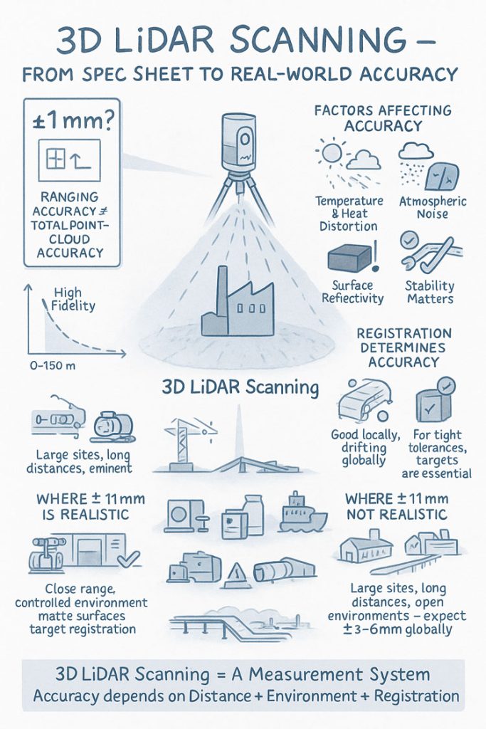
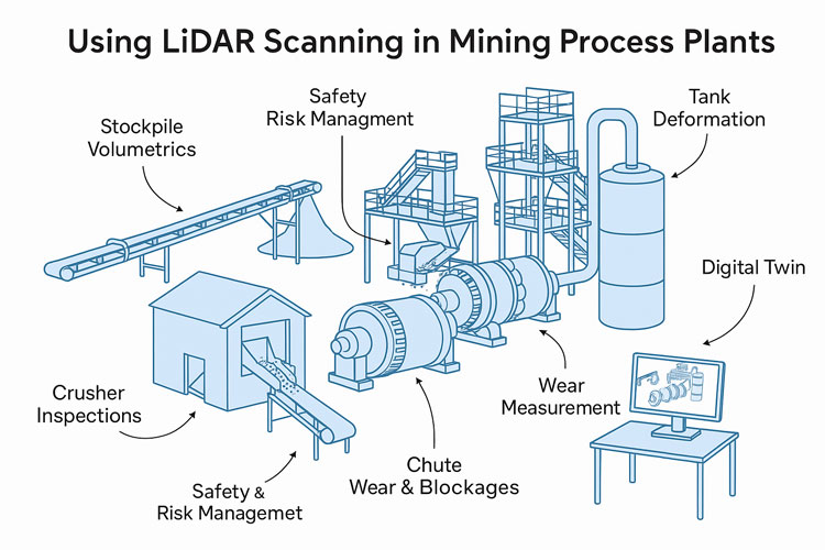
3D LiDAR Laser Scanning: Bringing Millimetre-Level Accuracy to Local Projects
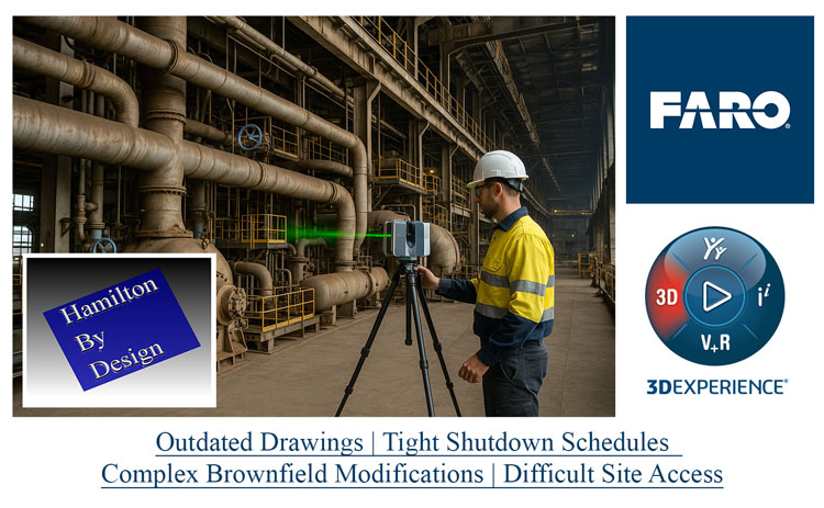
Whether youโ€™re working on a feed mill upgrade, a manufacturing facility expansion, a rural processing plant, a logistics warehouse fit-out or a mining-related modification, accurate site measurements are essential. Traditional surveys struggle to capture the complex geometry, alignment issues or hidden interferences common in brownfield environments.

Engineering-grade 3D LiDAR scanning solves this problem instantly.

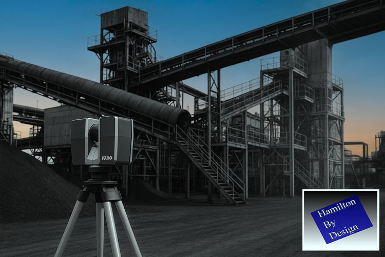
Hamilton By Design uses high-accuracy terrestrial laser scanners capable of capturing:

  • complex plant layouts
  • conveyors, chutes, structural frames
  • pipework routing and clashes
  • equipment misalignment
  • deflections, corrosion and wear
  • existing foundations and tie-in points
  • site terrain and building envelopes

All delivered with millimetre-level accuracy.

For Toowoomba businesses, this means:

  • reduced rework
  • faster fabrication
  • fewer shutdown overruns
  • safer installations
  • accurate as-built documentation

In a region where travel, mobilisation and shutdown timing matter, these improvements translate directly into cost savings and smoother project execution.


3D Modelling & Drafting for Toowoomba Industry

After scanning, the next step is turning point-cloud data into intelligent 3D models and fabrication-ready drawings.

Hamilton By Design specialises in:

  • SolidWorks mechanical modelling
  • structural modelling for plant systems
  • equipment layouts and upgrade designs
  • skid-based systems
  • brownfield modification design
  • drawing packages (GA, detail, isometric, BOMs)

For Toowoomba industries โ€” especially manufacturing workshops, agri-processing facilities, grain-handling plants, transport depots and rural engineering contractors โ€” accurate 3D models significantly improve design coordination.

We often hear clients say:

โ€œWe used to rely on tape measures and photos. Now we can see the entire plant from our office.โ€

That is exactly the transformation 3D modelling provides.


Mechanical Engineering for Brownfield Upgrades Across the Darling Downs

The Toowoomba region is rich in brownfield mechanical assets:
farm infrastructure, conveyor systems, grain silos, batching plants, food-processing lines, workshops, energy facilities and quarry machinery.

Hamilton By Design provides engineering support such as:

  • mechanical design for upgrades
  • structural integrity assessments
  • vibration, alignment and deflection reviews
  • buckling, fatigue and stress analysis (FEA)
  • chute, pipework and mechanical flow improvements
  • equipment mounting, lifting and access design

Our combination of engineer-led scanning + mechanical design ensures that every upgrade fits the first time and is supported by real data.


Why 3D Laser Scanning Is a Game-Changer for Toowoomba

Hereโ€™s where Toowoomba really benefits compared to many inland cities:

1. Large Agricultural Facilities Need Accurate Layouts

Feedlots, grain silos, packing sheds, processing plants and cold-storage facilities often evolve over many years. Scanning helps document these environments for compliance, redesign and expansion.

2. The Region Supports Mining & Energy Projects

Toowoomba acts as a service centre for the Surat Basin โ€” Dalby, Chinchilla, Miles, Roma.
LiDAR enables accurate tie-in points, pipe upgrades and shutdown planning.

3. Manufacturing & Fabrication Are Growing

Local workshops need precise data to avoid rework. Models based on point clouds give fabricators total confidence before cutting steel.

4. Logistics Infrastructure Continues Expanding

Wellcamp Airport, industrial estates and new warehousing projects benefit from accurate as-built documentation to speed up development approvals and construction decisions.

5. Reducing Travel Costs Is Critical for Regional Projects

A single scan eliminates multiple site trips โ€” crucial for Toowoombaโ€™s broad geographic service area.


Types of Toowoomba Projects Hamilton By Design Supports

Here are some of the local project types where our team adds immediate value:

  • grain-handling plant upgrades
  • feed mill expansions
  • water treatment & pumping stations
  • abattoir & food facility engineering
  • conveyor & materials-handling systems
  • batching plant upgrades
  • workshop fit-outs and machinery layouts
  • logistics warehouse redesigns
  • rural industrial buildings
  • mechanical equipment retrofits
  • energy & utility infrastructure

Whether itโ€™s a small workshop or a multi-hectare industrial site, LiDAR scanning gives project teams a crystal-clear digital representation of the site.


Single-Source Accountability:

Scanning โ†’ Modelling โ†’ Engineering โ†’ Drawings

One of the biggest frustrations in regional engineering is fragmented contractors โ€” one team scans, another models, another designs, and nobody takes responsibility when things donโ€™t align.

Hamilton By Design solves this with an integrated workflow:

  1. 3D LiDAR scan of the site
  2. Registration and accuracy validation
  3. 3D CAD modelling (SolidWorks)
  4. Mechanical & structural engineering
  5. Fabrication-ready drawings
  6. Digital QA and installation support

Everything is handled by a single engineering-led team.


Toowoombaโ€™s Future Needs Digital Engineering โ€” And Weโ€™re Here to Support It

Toowoomba is entering a decade of growth โ€” new industrial estates, expansions in agri-processing, energy transformation, airport-driven logistics and inland infrastructure.
Digital engineering will be a major part of how these projects are delivered efficiently and safely.

Hamilton By Design logo displayed on a blue tilted rectangle with a grey gradient background

Hamilton By Design is excited to provide Toowoomba businesses with:

  • precise 3D LiDAR scanning
  • mechanical engineering and assessment
  • professional 3D modelling and drafting
  • fabrication-ready design
  • digital documentation and QA

Whether youโ€™re planning a small plant improvement or a major regional upgrade, our data-driven approach helps you design with confidence.

Mechanical Plant Optimisation

Mechanical Plant Optimisation: Boosting Throughput, Reliability and Safety Across Australia

Industrial plants are under more pressure than ever to deliver higher output, reduce downtime and operate safely. Ageing equipment, inconsistent maintenance, and brownfield constraints often limit performance โ€” but with the right engineering approach, even long-running plants can achieve major efficiency gains.

At Hamilton By Design, we specialise in mechanical plant optimisation using a powerful combination of engineering expertise, high-accuracy LiDAR scanning, precise 3D modelling, and practical redesign strategies that deliver measurable improvements.

If your goal is higher throughput, fewer breakdowns and safer shutdowns, this guide explains how mechanical optimisation transforms plant performance.


Why Mechanical Plant Optimisation Is Essential

Most processing plants โ€” from CHPPs and quarries to manufacturing and power stations โ€” suffer from the same long-term issues:

  • Reduced throughput
  • Conveyor misalignment
  • Flow bottlenecks in chutes and transfer points
  • Vibration, cracking and structural fatigue
  • Outdated drawings and unknown modifications
  • Premature wear and high maintenance costs
  • Shutdown overruns due to poor fit-up

Optimisation tackles these issues using real engineering data, not assumptions.


Step 1: LiDAR Scanning to Capture True As-Built Conditions

As equipment ages, it moves, twists and wears in ways that drawings rarely capture. Our FARO laser scanners map a complete digital twin of your plant with ยฑ1โ€“2 mm accuracy, giving engineers:

  • Full geometry of structural frames
  • Wear patterns inside chutes
  • Deflection in platforms, conveyor trusses and supports
  • Misalignment in pipes, pulleys and mechanical drives
  • Clash risks for future upgrades

This becomes the foundation of all optimisation work โ€” ensuring upgrades fit first time.


Step 2: 3D Modelling & Engineering Redesign

Hamilton By Design converts point-cloud data into SolidWorks models to identify optimisation opportunities such as:

  • Reprofiling chutes for smoother flow
  • Strengthening or realigning structural members
  • Repositioning pumps or motors
  • Correcting conveyor and drive alignment
  • Redesigning access platforms for maintenance
  • Improving liner selection and service life

Every model is fabrication-ready, eliminating costly rework during shutdowns.


Step 3: Material Flow & Conveyor Performance Improvement

Flow constraints are one of the biggest sources of lost production. Through engineering review, modelling and experience, we address:

  • Impact zones causing excessive wear
  • Restrictive chute geometry
  • Poorly performing transfer points
  • Belt-tracking issues
  • Flow blockages
  • Inefficient material transitions

These improvements often deliver immediate gains in throughput and reliability.


Step 4: Mechanical Integrity & Reliability Assessments

We also perform condition assessments to understand the root causes of downtime:

  • Vibration analysis
  • Cracking and corrosion detection
  • Bearing, gearbox and pulley assessment
  • Thermal/overload risks
  • Misalignment and load distribution issues

This supports predictive maintenance and informed upgrade planning.


Step 5: Shutdown Planning & Upgrade Execution

By combining scanning, modelling and mechanical design, we ensure that every upgrade:

  • Fits perfectly into existing brownfield spaces
  • Reduces time on tools
  • Eliminates site modifications
  • Improves safety during installation
  • Delivers predictable shutdown timelines

Clients commonly see ROI within the first shutdown cycle.


Benefits of Mechanical Plant Optimisation

When optimisation is done properly, plants experience:

โœ” Measurable throughput increases

โœ” Longer equipment life

โœ” Reduced wear and maintenance costs

โœ” Safer operation and shutdown execution

โœ” Accurate documentation for future projects

โœ” Extended reliability of mechanical systems

With the right engineering support, even ageing plants can operate like new.


Serving Clients Across Australia

Hamilton By Design supports mechanical plant optimisation projects across:
Sydney, Newcastle, Hunter Valley, Central Coast, Bowen Basin, Surat Basin, Pilbara, Perth, Adelaide, Melbourne and regional Australia.

We work across mining, CHPPs, quarries, ports, power stations, manufacturing and heavy industrial sites.


Hamilton By Design logo displayed on a blue tilted rectangle with a grey gradient background

Ready to Optimise Your Plant?

If you want higher throughput, better reliability and safer operation, mechanical plant optimisation is the smartest investment you can make.

Or reach out directly for a project discussion.

Hamilton By Design โ€” Engineering Certainty for Complex Plants.


Name
You would like to:

Laser Scanning Hunter Valley: Delivering Engineering-Grade Accuracy for Mining, Manufacturing and Industrial Projects

The Hunter Valley remains one of Australiaโ€™s most important industrial regions. With world-class mining operations, CHPP facilities, fabrication workshops, power generation assets and major industrial precincts, the region depends on precision, reliability and efficient project planning. As plants age and infrastructure expands, the challenge of capturing accurate site information becomes increasingly critical.

This is why laser scanning in the Hunter Valley has rapidly become a foundational tool for maintenance, engineering, redesign, shutdown preparation and fabrication accuracy. Organisations across the region are turning to laser scanning because the demands of modern industrial work simply cannot be met with traditional tape measurements or outdated drawings.

Hamilton By Design is proud to deliver engineering-grade laser scanning throughout the Hunter Valley, supporting safer worksites, faster project execution and significantly improved installation outcomes. Below, we explore why laser scanning is essential, how the technology works and how it transforms operations across the region.


Why Laser Scanning Has Become Essential in the Hunter Valley

Across the Hunter, very few sites resemble their original drawings. Over decades, plants evolveโ€”structures deform, temporary fixes become permanent, equipment shifts, and countless undocumented modifications occur.

These realities create a major problem:
Projects that rely on inaccurate measurements inevitably face delays, rework and installation challenges.

The consequences of bad data include:

  • Structural steel not fitting on site
  • Conveyor alignment issues
  • Misaligned chutes or transfer points
  • Inaccurate pipe spool lengths
  • Unexpected clashes in congested areas
  • Extended shutdown duration
  • Significant cost blowouts

By contrast, laser scanning in the Hunter Valley provides a millimetre-accurate digital representation of the real site, eliminating uncertainty and enabling confident engineering decisions.


How Laser Scanning Works

Laser scanningโ€”also known as LiDAR (Light Detection and Ranging)โ€”captures millions of precise data points across a site in seconds. These points create a โ€œpoint cloud,โ€ a detailed 3D representation of the scanned environment.

The Hamilton By Design workflow typically includes:

1. On-Site High-Accuracy Capture

We scan assets such as:

  • Structural frames
  • Conveyors, transfer towers and walkways
  • Chutes, bins, hoppers and material-handling systems
  • Tanks and pipe networks
  • Mechanical equipment
  • Buildings and platforms
  • Processing areas and plant rooms

Scanning is performed safely, quickly and with minimal disruption to operations.

2. Point Cloud Processing

Individual scans are aligned and merged into a single, unified as-built dataset.

3. CAD Modelling

From the point cloud, we create:

  • Accurate 3D models
  • General arrangement drawings
  • Fabrication details
  • DXF files for workshop use
  • Digital templates for pattern development

4. Engineering & Fabrication Support

We run digital checks for:

  • Clearances
  • Misalignments
  • Bolt pattern accuracy
  • Clash detection
  • Fit-up assurance

This ensures all new components, structures and mechanical systems integrate correctly the first time.


Industries in the Hunter Valley Using Laser Scanning

1. Mining & Coal Handling Preparation Plants (CHPPs)

The Hunter Valley is one of Australiaโ€™s largest mining hubs, and laser scanning has become indispensable for:

  • Chute redesign and optimisation
  • Conveyor alignment and pulley checks
  • Structural replacements
  • Screening and crushing system upgrades
  • Transfer tower modifications
  • Bin and hopper geometry capture
  • Shutdown planning and scope definition

In CHPP environmentsโ€”where dust, vibration, wear and deformation are constantโ€”accurate as-built data is essential for safe and efficient upgrades.


2. Local Fabrication Workshops

Fabricators across Singleton, Muswellbrook, Rutherford and Thornton rely on precise digital information to ensure their products fit perfectly in the field. Laser scanning supports:

  • Steel replacement projects
  • Pipe spool fabrication
  • Custom chutes and transfer systems
  • Platform and walkway upgrades
  • Reverse engineering worn components

By basing fabrication on exact site geometry, rework and installation delays are dramatically reduced.


3. Power Stations and Energy Infrastructure

The Hunter Valley contains major energy assets requiring constant maintenance and upgrades. These aging facilities benefit greatly from laser scanning for:

  • Structural integrity assessments
  • Boiler house modifications
  • Pipe rerouting and replacements
  • Access platform upgrades
  • Plant room modelling
  • Compliance documentation

Laser scanning supports safe access, better planning and accurate engineering.


4. Industrial, Manufacturing and Infrastructure Projects

The regionโ€™s industrial footprint is expanding, and many facilities require precise as-built data for:

  • Renovations or expansions
  • Facility mapping
  • Mechanical upgrades
  • Brownfield redevelopment
  • BIM integration

Laser scanning provides the detail needed to plan these works correctly.


Benefits of Laser Scanning in the Hunter Valley

1. Millimetre Accuracy

Unlike manual measurements, laser scanning captures true geometryโ€”not assumptions.

2. Reduced Rework

Digitally verified data ensures that fabrication is correct the first time.

3. Improved Safety

No need for workers to climb, stretch, or enter hazardous areas to measure.

4. Faster Shutdowns

Accurate pre-planning reduces onsite delays.

5. Digital Collaboration

Point clouds allow teams, contractors and engineers to review the site remotely.

6. Enhanced Engineering Confidence

Decisions are made on verified data, improving outcomes across the entire project lifecycle.


The Hamilton By Design Advantage

Hamilton By Design delivers more than just scanningโ€”we combine decades of engineering, drafting and fabrication experience to interpret the data with real-world understanding.

What Sets Us Apart:

Engineering-Driven Approach

We understand the mechanical and structural context behind each scan.

Full Digital Workflow

From scan โ†’ point cloud โ†’ 3D model โ†’ fabrication drawings โ†’ installation, we support your entire project.

Local Knowledge of Hunter Valley Industry

We work routinely with mines, CHPPs, fabricators and industrial facilities across the region.

Fabrication-Ready Outputs

All models and drawings are created with workshop requirements and site constraints in mind.

Confidence Before Installation

We digitally confirm fitment before steel is cutโ€”removing risk.


Applications Where Laser Scanning Delivers Immediate Value

  • Chute replacements
  • Conveyor system upgrades
  • Access platforms and walkways
  • Crusher and screen changes
  • Transfer tower redesign
  • Pipe spool fabrication
  • Structural steel alignment checks
  • Bin, tank and hopper measurement
  • Reverse engineering
  • Brownfield plant expansions

Anywhere accuracy matters, scanning is the superior choice.


Laser Scanning in the Hunter Valley: The New Standard

Across the region, laser scanning is now considered a must-have for safe, efficient and predictable project delivery. As plants age and the complexity of upgrades increases, organisations that invest in accurate data significantly outperform those relying on outdated drawings or manual measuring.

For engineering teams, maintenance planners, workshop fabricators and shutdown coordinators, laser scanning provides the certainty required to deliver work on time and on budget.


Partner with Hamilton By Design

When you choose Hamilton By Design for laser scanning in the Hunter Valley, youโ€™re choosing:

  • Accuracy
  • Safety
  • Engineering reliability
  • Better planning
  • Reduced risk
  • Efficient installation

Weโ€™re ready to support your next shutdown, upgrade, redesign or fabrication project with the digital precision it deserves.

Contact Hamilton By Design today to discuss your site and discover how laser scanning can transform your project outcomes.

Hamilton By Design logo displayed on a blue tilted rectangle with a grey gradient background

Hunter Valley Laser Scanning: Transforming Engineering Accuracy Across Mining, Manufacturing and Infrastructure

3D Laser Scanning in Singleton and the Hunter: Delivering Accuracy for Mining, Manufacturing and Industrial Projects

3D Laser Scanning

3D Scanning in The Hunter Valley

Name
You would like to:

The Real-World Accuracy of 3D LiDAR Scanning With FARO S150 & S350 Scanners

When people first explore 3D LiDAR scanning, one of the most eye-catching numbers in any product brochure is the advertised accuracy. FAROโ€™s Focus S150 and S350 scanners are often promoted as delivering โ€œยฑ1 mm accuracy,โ€ which sounds definitive and easy to rely on for engineering, mining and fabrication work. But anyone who has spent time working with 3D LiDAR scanning in real industrial environments understands that accuracy isnโ€™t a single number โ€” it is a system of interrelated factors.

This article explains what the ยฑ1 mm specification from FARO really means, how accuracy shifts with distance, and what engineers, project managers and clients need to do to achieve dependable results when applying 3D LiDAR scanning on live sites.


Infographic explaining 3D LiDAR scanning accuracy, showing a scanner capturing a building and highlighting factors that affect accuracy such as temperature, atmospheric noise, surface reflectivity and tripod stability. Includes diagrams comparing realistic versus unrealistic ยฑ1 mm accuracy, the impact of distance, environment and registration quality, and notes that large open sites typically achieve ยฑ3โ€“6 mm global accuracy.

1. What FAROโ€™s โ€œยฑ1 mm Accuracyโ€ Really Means in 3D LiDAR Scanning

The ยฑ1 mm number applies only to the internal distance measurement unit inside the scanner. It reflects how accurately the laser measures a single distance in controlled conditions.

It does not guarantee:

  • ยฑ1 mm for every point in a full plant model
  • ยฑ1 mm for every dimension extracted for engineering
  • ยฑ1 mm global accuracy across large multi-scan datasets

In 3D LiDAR scanning, ranging accuracy is just one ingredient. Real-world accuracy is shaped by distance, reflectivity, scan geometry and how multiple scans are registered together.


2. How Accuracy Changes With Distance in Real Projects

Even though the S150 and S350 list the same ranging accuracy, their 3D LiDAR scanning performance changes as distance increases. This is due to beam divergence, angular error, environment and surface reflectivity.

Typical real-world behaviour:

  • 0โ€“10 m: extremely precise, often sub-millimetre
  • 10โ€“25 m: excellent for engineering work, only slight noise increase
  • 25โ€“50 m: more noticeable noise and increasing angular error
  • 50โ€“100 m: atmospheric distortion and reduced overlap become evident
  • Near maximum range: still useful for mapping conveyors, yards and structures, but not suitable for tight fabrication tolerances

This distance-based behaviour is one of the most important truths to understand about 3D LiDAR scanning in field conditions.


3. Ranging Accuracy vs Positional Accuracy vs Global Accuracy

Anyone planning a project involving 3D LiDAR scanning must distinguish between:

Ranging Accuracy

The ยฑ1 mm value โ€” only the distance measurement.

3D Positional Accuracy

The true X/Y/Z location of a point relative to the scanner.

Global Point Cloud Accuracy

How accurate the entire dataset is after registration.

Global accuracy is the number engineers depend on, and it is normally around ยฑ3โ€“6 mm for large industrial sites โ€” completely normal for terrestrial 3D LiDAR scanning.


4. What Real Field Testing Reveals About FARO S-Series Accuracy

Independent practitioners across mining, infrastructure, CHPPs, plants and structural environments report similar results when validating 3D LiDAR scanning against survey control:

  • ยฑ2โ€“3 mm accuracy in compact plant rooms
  • ยฑ5โ€“10 mm across large facilities
  • Greater drift across long, open, feature-poor areas

These outcomes are not equipment faults โ€” they are the natural result of how 3D LiDAR scanning behaves in open, uncontrolled outdoor environments.


5. Why Registration Matters More Than the Scanner Model

Most real-world error in 3D LiDAR scanning comes from registration, not the laser itself.

Cloud-to-Cloud Registration

Good for dense areas, less reliable for long straight conveyors, open yards or tanks.

Target-Based Registration

Essential for high-precision engineering work.
Allows tie-in to survey control and dramatically improves global accuracy.

If your project needs ยฑ2โ€“3 mm globally, target control is mandatory in all 3D LiDAR scanning workflows.


6. Surface Reflectivity and Environmental Effects

Reflectivity dramatically affects measurement quality during 3D LiDAR scanning:

  • Matte steel and concrete return excellent data
  • Rusted surfaces return good data
  • Dark rubber, black plastics and wet surfaces reduce accuracy
  • Stainless steel and glass behave unpredictably

Environmental factors โ€” wind, heat shimmer, dust, rain โ€” also reduce accuracy. Early morning or late afternoon typically produce better 3D LiDAR scanning results on mining and industrial sites.


7. When ยฑ1 mm Is Actually Achievable

True ยฑ1 mm accuracy in 3D LiDAR scanning is realistic when:

  • Working within 10โ€“15 m
  • Surfaces are matte and reflective
  • Registration uses targets
  • Tripod stability is high
  • Conditions are controlled

This makes it suitable for:

  • Pump rooms
  • Valve skids
  • Structural baseplates
  • Reverse engineering
  • Small mechanical upgrades

But achieving ยฑ1 mm across a full plant, CHPP, or yard is outside the capability of any terrestrial 3D LiDAR scanning workflow.


8. S150 vs S350: Which One for Your Accuracy Needs?

S150 โ€“ Engineering-Focused Precision

Ideal for industrial rooms, skids, structural steel and retrofit design work where short-to-mid-range accuracy is essential.

S350 โ€“ Large-Area Coverage

Perfect for conveyors, rail lines, yards, and outdoor infrastructure.
Global accuracy must be survey-controlled for tight tolerances.

Both scanners deliver excellent 3D LiDAR scanning performance, but the S150 is the engineering favourite while the S350 is the large-site specialist.


9. What to Specify in Contracts to Avoid Misunderstandings

Instead of stating:

โ€œScanner accuracy ยฑ1 mm.โ€

Specify:

  • Local accuracy requirement (e.g., ยฑ2 mm at 15 m)
  • Global accuracy requirement (e.g., ยฑ5 mm total dataset)
  • Registration method (mandatory target control)
  • Environmental constraints
  • Verification method (e.g., independent survey checks)

This ensures everyone understands what 3D LiDAR scanning will realistically deliver.


10. When a Terrestrial Scanner Is Not Enough

Do not rely solely on 3D LiDAR scanning for:

  • Machine alignment <1 mm
  • Bearing or gearbox placement
  • Certified dimensional inspection
  • Metrology-level tolerances

In these cases, supplement scanning with:

  • Laser trackers
  • Total stations
  • Metrology arms
  • Hybrid workflows

Conclusion: The Real Truth About 3D LiDAR Scanning Accuracy

FAROโ€™s S150 and S350 are outstanding tools for industrial 3D LiDAR scanning, but the ยฑ1 mm spec does not tell the full story. Real-world accuracy is a combination of:

  • Distance
  • Registration method
  • Surface reflectivity
  • Site conditions
  • Workflow discipline

When used correctly, these scanners consistently deliver high-quality, engineering-grade point clouds suitable for clash detection, retrofit design, fabrication planning and as-built documentation.

3D LiDAR scanning is not just a laser โ€” it is an entire measurement system.
And when the system is applied with care, it produces reliable, repeatable data that reduces rework, improves safety, and strengthens decision-making across mining, construction, fabrication and industrial operations.

Where Is your project

3D Scanning Sydney CBD3D Scanning Brisbane CBD
3D Scanning across Melbourne3D Scanning across Perth
3D Scanning across Adelaide3D Scanning in The Hunter Valley
3D Scanning Mount Isa3D Scanning Emerald
3D Laser Scanning Central Coast3D Scanning in The Pilbara
3d Scanning other Areas of Australia3D Scanning Outside Australia
Hamilton By Design logo displayed on a blue tilted rectangle with a grey gradient background
Name
You would like to:

3D CAD Modelling | 3D Scanning

3D Experience Platform Login

3D Scanning for Construction

Transforming Projects with 3D Scanning

3D LiDAR Scanning โ€“ Digital Quality Assurance

3D Scanning for Industrial Projects in Newcastle and the Hunter Valley

Engineering the Hunter: Precision Meets Industry

Few regions in Australia represent heavy industry quite like Newcastle and the Hunter Valley.
From the coal mines at Bengalla and Mount Thorley, to the power stations at Bayswater and Eraring, to the Port of Newcastleโ€™s massive shiploaders and conveyors, this region has powered Australia for generations.

But with age, complexity, and constant upgrades come challenges:

  • Outdated drawings
  • Tight shutdown schedules
  • Complex brownfield modifications
  • Difficult site access

Thatโ€™s where 3D scanning and LiDAR modelling are transforming how industrial projects are designed, verified, and delivered โ€” ensuring every bolt, beam, and bracket fits perfectly the first time.

At Hamilton By Design, we bring together field experience, digital precision, and local knowledge to help the Hunterโ€™s industries design, maintain, and modernise with confidence.


Technician operating a FARO 3D laser scanner inside an industrial plant to capture accurate geometry for brownfield upgrades, shown alongside Hamilton By Design and 3DEXPERIENCE logos with highlighted challenges such as outdated drawings and tight shutdown schedules

What Is 3D Scanning โ€” and Why It Matters in Industry

3D laser scanning, also known as LiDAR (Light Detection and Ranging), captures millions of data points across an industrial site to create a precise digital representation โ€” known as a point cloud.

This point cloud forms the foundation of a digital twin of your plant or asset โ€” an exact, measurable 3D environment that engineers can design within using SolidWorks, AutoCAD, or Navisworks.

The result?
Every measurement is accurate, every clash is detected before fabrication, and every installation happens exactly as planned.


Why Newcastle and the Hunter Valley Need Scanning More Than Ever

The Hunter is an engineering powerhouse โ€” but much of its infrastructure was built decades ago.
Many coal handling plants, power stations, and smelters are now in a constant cycle of refurbishment, retrofit, and compliance upgrade.

The challenges are familiar:

  • Old 2D drawings donโ€™t reflect todayโ€™s reality.
  • Assets have been modified repeatedly over decades.
  • Shutdown windows are shrinking.
  • Every error adds cost and delays production.

By scanning before you design, you remove uncertainty.
You donโ€™t guess clearances โ€” you know them.
You donโ€™t estimate tie-in points โ€” you model them.
You donโ€™t hope it fits โ€” you prove it digitally.

Thatโ€™s the power of 3D scanning in todayโ€™s industrial environment.


FARO 3D laser scanner set up on a tripod capturing an industrial plant for LiDAR scanning and digital modelling, with Hamilton By Design branding in the corner

Where Scanning Adds Value Across the Hunterโ€™s Industries

โš™๏ธ Power Generation

The Bayswater, Eraring, and Vales Point Power Stations are engineering icons.
Upgrades to cooling systems, ducts, platforms, and access structures require millimetre accuracy.
3D scanning ensures:

  • Every retrofit aligns with existing steelwork and pipework.
  • Structural interferences are caught before fabrication.
  • Shutdown work can be completed on time โ€” without rework.

Whether itโ€™s a fan casing replacement or a duct reroute, laser scanning removes the guesswork from aging assets.


โ›๏ธ Coal Handling and CHPP Facilities

The Hunter Valleyโ€™s CHPP network โ€” Mount Thorley Warkworth, Ravensworth, Bengalla, Hunter Valley Operations โ€” all depend on reliable mechanical systems.
These plants evolve continuously: diverter chutes, screen replacements, conveyors, and wash plant modifications.

Scanning delivers:

  • Accurate as-built geometry for plant upgrades.
  • Clash detection between new and existing equipment.
  • Shutdown planning certainty โ€” no unexpected fit-up issues.
  • Integration of SolidWorks models directly into point clouds for visual verification.

For CHPP managers and maintenance engineers, 3D scanning is now as essential as the plant itself.

Composite image showing an Australian Standard compliance graphic, a LiDAR point-cloud scan of a coal reclaimer with inspection markers, and the Hamilton By Design logo

โš“ Port of Newcastle and Coal Export Terminals

Newcastleโ€™s port is the lifeline of the Hunterโ€™s economy.
Facilities such as Port Waratah Coal Services (PWCS), Newcastle Coal Infrastructure Group (NCIG), and Carrington Terminal handle massive volumes of coal every hour.

The complexity of these sites โ€” shiploaders, conveyors, gantries, and stacker-reclaimers โ€” demands accuracy during maintenance and upgrade works.
3D scanning supports:

  • Shiploader upgrades and boom extensions.
  • Conveyor and transfer tower alignment checks.
  • Wharf structure condition monitoring.
  • Integration with mechanical and electrical systems.

By scanning before modification, downtime is reduced, safety improves, and project teams gain total confidence in every fit-up.


๐Ÿญ Aluminium and Heavy Manufacturing

At Tomago Aluminium Smelter, precision is everything.
The scale of the site โ€” from potlines to switchyards โ€” makes manual measurement impractical and unsafe.

Laser scanning captures geometry accurately across large areas, enabling:

  • Retrofit planning without full shutdowns.
  • Clearance checks for cranes, ducts, and potline infrastructure.
  • Digital twins for long-term maintenance and asset management.

Beyond Tomago, manufacturers in Waratah, Beresfield, and Thornton use scanning to validate jigs, fixtures, and workshop layouts โ€” ensuring local fabrication accuracy that matches site requirements.


๐Ÿ”‹ Emerging Energy and Infrastructure

As the Hunter region transitions toward renewable and low-emission industries, scanning plays a critical role in planning new infrastructure around existing sites.
This includes:

  • Hydrogen and gas pipeline tie-ins.
  • Solar and battery installations near existing grid connections.
  • Conversion of existing power plant structures for new technology.

Accurate point-cloud data ensures new energy meets old infrastructure safely and efficiently.


From Field to Fabrication: The Hamilton By Design Process

At Hamilton By Design, our 3D scanning workflow is built around practical, industrial needs:

  1. Site Scan & Data Capture
    Using high-precision LiDAR scanners, we safely capture full site geometry in hours, not weeks.
    Scans are performed during operation or short shutdowns, without interrupting production.
  2. Point Cloud Registration & Processing
    Multiple scans are aligned to create a unified, accurate model of your facility.
    The result is a true โ€œdigital twinโ€ of your asset, complete with millimetre accuracy.
  3. SolidWorks Modelling & Integration
    Our design team converts scan data into fully functional 3D models โ€” chutes, pipework, platforms, or structural frames โ€” ready for fabrication.
  4. Clash Detection & Design Validation
    Every new design is tested within the digital twin, ensuring it fits the first time.
  5. Fabrication Drawings & e-Drawings
    Detailed 2D and 3D deliverables are provided for fabricators, site crews, and certifiers โ€” ensuring seamless communication between design and construction.

Why Local Expertise Matters

Many engineering firms offer scanning โ€” but few understand what it takes to work on a live plant in the Hunter Valley.

Hamilton By Design combines trade experience, mechanical design, and regional understanding.
Weโ€™ve worked with the same assets, fabricators, and contractors who keep the regionโ€™s power, port, and manufacturing industries running.

We design for real fabrication conditions โ€” using Australian Standards, local materials, and practical build methods.
That means fewer redesigns, faster turnarounds, and safer installations.


Safety and Access: Scanning Without Shutdowns

Traditional site measurement often means working at heights, in confined spaces, or around operating equipment.
3D scanning eliminates those risks.

Our scanners capture data safely from the ground โ€” even in restricted or hazardous areas.
This not only improves safety but also allows projects to continue without halting production.

For large plants like Eraring or PWCS, scanning entire structures during live operation is now standard practice โ€” enabling ongoing maintenance and long-term asset integrity planning.


Case Example: Port Upgrade Without Rework

A local contractor approached Hamilton By Design for a conveyor and tower modification project at the Port of Newcastle.
Existing drawings were decades old, and the structure had been modified repeatedly.

We performed a 3D scan of the tower and adjacent conveyors, capturing the as-built geometry in one day.
The resulting model revealed several misalignments between the planned chute and existing supports.
By correcting these in SolidWorks before fabrication, the contractor avoided at least 48 hours of site rework and kept the shutdown on schedule.

Thatโ€™s measurable ROI โ€” precision that pays for itself.


The ROI of 3D Scanning in Heavy Industry

A single hour of lost production at a CHPP or power station can cost $20,000 to $50,000.
A single dayโ€™s delay can exceed $500,000 in lost revenue and labour costs.

3D scanning reduces that risk by eliminating rework and ensuring every component fits right the first time.
Typical return on investment (ROI):

  • Scanning cost: <1% of total project value.
  • Rework savings: 3โ€“10% of total cost.
  • Downtime reduction: 1โ€“3 days saved per shutdown.

When accuracy drives reliability, 3D scanning isnโ€™t an expense โ€” itโ€™s insurance.


Supporting the Hunterโ€™s Future

Newcastle and the Hunter Valley are evolving โ€” from coal and power to renewables, advanced manufacturing, and logistics.
But one thing hasnโ€™t changed: the regionโ€™s foundation in engineering, precision, and hard work.

Hamilton By Design supports that legacy with the next generation of technology โ€” scanning, digital modelling, and mechanical design that keep the regionโ€™s assets efficient, safe, and ready for the future.

Weโ€™re not an offshore CAD vendor.
Weโ€™re local engineers whoโ€™ve worked in the field, understand your equipment, and speak the same language as your crews.


Letโ€™s Build the Future of Hunter Industry โ€“ Accurately

Every project starts with one question: โ€œDo we have accurate site data?โ€

With Hamilton By Design, the answer is always yes.

We deliver:
โœ… 3D laser scanning and LiDAR modelling
โœ… Point-cloud to SolidWorks integration
โœ… Reverse engineering and FEA validation
โœ… Fabrication drawings tailored for local workshops
โœ… On-site consultation with practical engineering insight

Whether youโ€™re upgrading a conveyor at Bayswater, fabricating platforms for Tomago, or retrofitting process piping at Kooragang, we ensure your next project fits perfectly โ€” before steel is cut.

Banner displaying Hamilton By Design alongside partner and technology logos including SolidWorks, UTS, Dassault Systรจmes 3DEXPERIENCE, and FARO, with the text โ€˜3D Scanning 3D Modellingโ€™ and website www.hamiltonbydesign.com.au.

๐Ÿ‘‰ Get your industrial site scanned and modelled before your next shutdown.
Visit www.hamiltonbydesign.com.au or contact us to request a capability statement today.

Mechanical Engineering | Structural Engineering

Mechanical Drafting | Structural Drafting

3D CAD Modelling | 3D Scanning

Hamilton By Design Logo

Seeing the Unseen: How LiDAR Scanning is Transforming Mining Process Plants

In modern mining, where uptime is money and safety is non-negotiable, understanding the geometry of your process plant is critical. Every conveyor, chute, pipe rack, and piece of equipment must fit together seamlessly and operate reliably โ€” but plants are messy, dusty, and constantly changing. Manual measurement with a tape or total station is slow, risky, and often incomplete.

nfographic showing how LiDAR scanning is used in mining process plants, with illustrations of conveyors, crushers, tanks, mills and chutes. Labels highlight applications such as stockpile volumetrics, crusher inspections, safety and risk management, chute wear and blockages, mill wear measurement, tank deformation monitoring and creating digital twins.

This is where LiDAR scanning (Light Detection and Ranging) has become a game-changer. By capturing millions of precise 3D points per second, LiDAR gives engineers, maintenance planners, and operators an exact digital replica of the plant โ€” without climbing scaffolds or shutting down equipment. In this post, weโ€™ll explore how mining companies are using LiDAR scanning to solve real problems in processing plants, improve safety, and unlock operational efficiency.


What Is LiDAR Scanning?

LiDAR is a remote sensing technology that measures distance by firing pulses of laser light and recording the time it takes for them to return. Modern terrestrial and mobile LiDAR scanners can:

  • Capture hundreds of thousands to millions of points per second
  • Reach tens to hundreds of meters, depending on the instrument
  • Achieve millimeter-to-centimeter accuracy
  • Work in GPS-denied environments, such as inside mills, tunnels, or enclosed plants (using SLAM โ€” Simultaneous Localization and Mapping)

The output is a point cloud โ€” a dense 3D dataset representing surfaces, equipment, and structures with stunning accuracy. This point cloud can be used as-is for measurements or converted into CAD models and digital twins.


Why Process Plants Are Perfect for LiDAR

Unlike greenfield mine sites, processing plants are some of the most geometry-rich and access-constrained areas on site. They contain:

  • Complex networks of pipes, conveyors, tanks, and structural steel
  • Moving equipment such as crushers, mills, and feeders
  • Dusty, noisy, and hazardous environments with limited safe access

All these factors make traditional surveying difficult โ€” and sometimes dangerous. LiDAR enables โ€œno-touchโ€ measurement from safe vantage points, even during operation. Multiple scans can be stitched together to create a complete model without shutting down the plant.


Applications of LiDAR in Process Plants

1. Wear Measurement and Maintenance Planning

LiDAR has revolutionized how mines measure and predict wear on critical process equipment:

  • SAG and Ball Mill Liners โ€“ Portable laser scanners can capture the exact wear profile of liners. Comparing scans over time reveals wear rates, helping maintenance teams schedule relines with confidence and avoid premature failures.
  • Crusher Chambers โ€“ Scanning inside primary and secondary crushers is now faster and safer than manual inspections. The resulting 3D model allows engineers to assess liner life and optimize chamber profiles.
  • Chutes and Hoppers โ€“ Internal scans show where material buildup occurs, enabling targeted cleaning and redesign to prevent blockages.

Result: Reduced downtime, safer inspections, and better forecasting of maintenance budgets.


2. Retrofit and Expansion Projects

When modifying a plant โ€” installing a new pump, rerouting a pipe, or adding an entire circuit โ€” having an accurate โ€œas-builtโ€ model is crucial.

  • As-Built Capture โ€“ LiDAR provides an exact snapshot of the existing plant layout, eliminating guesswork.
  • Clash Detection โ€“ Designers can overlay new equipment models onto the point cloud to detect interferences before anything is fabricated.
  • Shutdown Optimization โ€“ With accurate geometry, crews know exactly what to cut, weld, and install โ€” reducing surprise field modifications and shortening shutdown durations.

3. Inventory and Material Flow Monitoring

LiDAR is not just for geometry โ€” itโ€™s also a powerful tool for tracking material:

  • Stockpile Volumetrics โ€“ Mounted scanners on stackers or at fixed points can monitor ore, concentrate, and product stockpiles in real time.
  • Conveyor Load Measurement โ€“ Stationary LiDAR above belts calculates volumetric flow, giving a direct measure of throughput without contact.
  • Blending Control โ€“ Accurate inventory data improves blending plans, ensuring consistent plant feed quality.

4. Safety and Risk Management

Perhaps the most valuable application of LiDAR is keeping people out of harmโ€™s way:

  • Hazardous Floor Areas โ€“ When flooring or gratings fail, robots or drones with LiDAR payloads can enter the area and collect data remotely.
  • Fall-of-Ground Risk โ€“ High walls, bin drawpoints, and ore passes can be scanned for unstable rock or buildup.
  • Escape Route Validation โ€“ Scans verify clearances for egress ladders, walkways, and platforms.

Every scan effectively becomes a permanent digital record โ€” a baseline for monitoring ongoing structural integrity.


5. Digital Twins and Advanced Analytics

A plant-wide LiDAR scan is the foundation of a digital twin โ€” a living, data-rich 3D model connected to operational data:

  • Combine scans with SCADA, IoT, and maintenance systems
  • Visualize live process variables in context (flow rates, temperatures, vibrations)
  • Run โ€œwhat-ifโ€ simulations for debottlenecking or energy optimization

As AI and simulation tools mature, the combination of geometric fidelity and operational data opens new possibilities for predictive maintenance and autonomous plant operations.


Emerging Opportunities

Looking forward, there are several promising areas for LiDAR in mining process plants:

  • Autonomous Scan Missions โ€“ Using quadruped robots (like Spot) or SLAM-enabled drones to perform routine scanning in high-risk zones.
  • Real-Time Change Detection โ€“ Continuous scanning of critical assets with alerts when deformation exceeds thresholds.
  • AI-Driven Point Cloud Analysis โ€“ Automatic object recognition (valves, flanges, motors) to speed up model creation and condition reporting.
  • Integrated Planning Dashboards โ€“ Combining LiDAR scans, work orders, and shutdown schedules in a single interactive 3D environment.

Best Practices for Implementing LiDAR

To maximize the value of LiDAR scanning, consider:

  1. Define the Objective โ€“ Are you measuring wear, planning a retrofit, or building a digital twin? This affects scanner choice and resolution.
  2. Plan Scan Positions โ€“ Minimize occlusions and shadow zones by preplanning vantage points.
  3. Use Proper Registration โ€“ Tie scans to a control network for consistent alignment between surveys.
  4. Mind the Environment โ€“ Dust, fog, and vibration can degrade data; choose scanners with appropriate filters or protective housings.
  5. Invest in Processing Tools โ€“ The raw point cloud is only the start โ€” software for meshing, modeling, and analysis is where value is extracted.
  6. Train Your Team โ€“ Build internal capability for scanning, processing, and interpreting the results to avoid vendor bottlenecks.

Infographic showing a 3D LiDAR scanner on a tripod surrounded by eight best-practice principles: start with clear objectives, plan your scanning campaign, prioritize safety, optimize data quality, ensure robust registration and georeferencing, establish repeatability, integrate with downstream systems, and train people with documented procedures

LiDAR scanning is no longer a niche technology โ€” it is rapidly becoming a standard tool for mining process plants that want to operate safely, efficiently, and with fewer surprises. From mill liners to stockpiles, from shutdown planning to digital twins, LiDAR provides a clear, measurable view of assets that was impossible a decade ago.

For operations teams under pressure to deliver more with less, the case is compelling: better data leads to better decisions. And in a high-stakes environment like mineral processing, better decisions translate directly to improved uptime, reduced costs, and safer workplaces.

The next time youโ€™re planning a shutdown, a retrofit, or even just trying to understand why a chute is plugging, consider pointing a LiDAR scanner at the problem. You may be surprised at how much more you can see โ€” and how much time and money you can save.

3D Scanning | Mining Surface Ops | 3D Modelling

Mechanical Engineering | Structural Engineering

Mechanical Drafting | Structural Drafting

3D CAD Modelling | 3D Scanning

Chute Design

SolidWorks Contractors in Australia

Hamilton By Design โ€“ Blog