Engineering-Grade 3D Scanning in Papua New Guinea

3D laser scanner capturing point cloud data of remote processing plant.

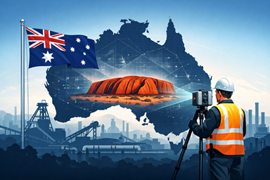
Papua New Guinea presents some of the most demanding industrial environments in the Asia-Pacific region. Remote terrain, ageing infrastructure, complex plant layouts and tight shutdown windows demand precision, efficiency and engineering certainty.

Hamilton By Design delivers engineering-grade 3D scanning services in Papua New Guinea, supporting mining, processing, infrastructure and industrial projects with accurate digital capture and practical engineering outcomes.

If you are planning a plant expansion, shutdown upgrade, brownfield modification or condition assessment in PNG, high-resolution laser scanning provides the clarity your project needs.

๐Ÿ‘‰ Learn more about our dedicated PNG services here:
https://www.hamiltonbydesign.com.au/3d-scanning-papua-new-guinea/


Industrial mining facility in PNG captured with engineering-grade 3D scanning technology.

Why 3D Laser Scanning Matters in PNG

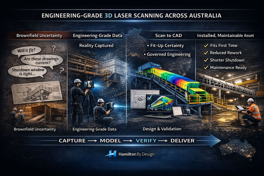
Traditional measurement methods are time-consuming and prone to error โ€” especially in remote or operational sites. 3D laser scanning eliminates guesswork by capturing millions of precise data points in a matter of hours.

The result is a complete and reliable as-built digital record of your asset.

This enables:

  • Accurate retrofit and tie-in design
  • Reduced site revisits
  • Improved shutdown planning
  • Clash detection before fabrication
  • Safer project execution

In remote PNG environments, reducing mobilisation and rework is not just convenient โ€” it is critical to project success.


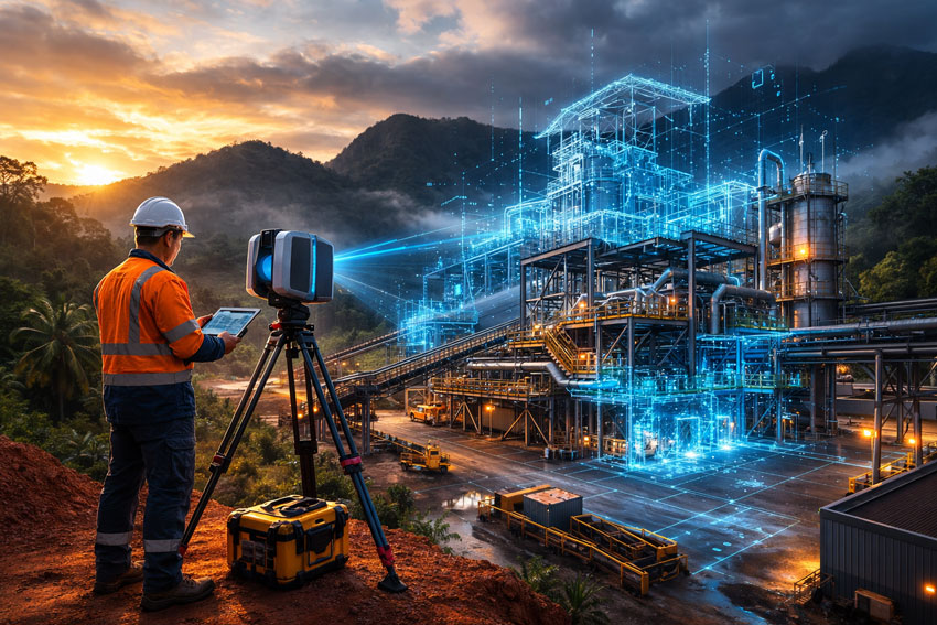
From Point Cloud to Engineering Outcome

At Hamilton By Design, we go beyond scanning.

We transform raw point cloud data into usable engineering outputs including:

  • SolidWorks-ready 3D models
  • Structural and mechanical layouts
  • Fabrication drawings
  • Design verification data
  • Digital asset records

Our difference is simple: we are engineers first. Scanning is integrated directly into mechanical and structural design workflows, ensuring data captured onsite translates into practical, buildable solutions.

For a broader overview of our national capability, explore our full 3D laser scanning services here:
https://www.hamiltonbydesign.com.au/home/engineering-services/3d-laser-scanning/


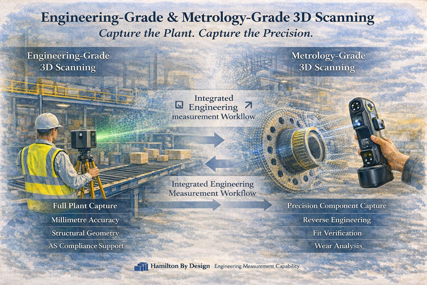
Supporting Mining & Industrial Projects Across Papua New Guinea

Our PNG capability supports:

  • Mining processing plants
  • Conveyors and transfer stations
  • Pump stations and pipework systems
  • Structural steel and platforms
  • Smelter and refinery infrastructure
  • Brownfield plant upgrades

Whether your site is operational, remote or in early planning stages, we deliver data accuracy that reduces risk and accelerates decision-making.


Reduce Risk. Increase Certainty.

In complex industrial environments, uncertainty drives cost.

3D laser scanning provides:

  • Accurate geometry
  • Faster design cycles
  • Reduced fabrication errors
  • Improved stakeholder confidence

When combined with Hamilton By Designโ€™s engineering capability, it becomes a powerful project delivery tool.


Delivering Engineering Certainty in Papua New Guinea

If your organisation is undertaking upgrades, expansions or asset assessments in Papua New Guinea, we are ready to support your project.

Explore our dedicated PNG scanning capability:
๐Ÿ‘‰ https://www.hamiltonbydesign.com.au/3d-scanning-papua-new-guinea/

Or view our broader engineering-led 3D laser scanning services:
๐Ÿ‘‰ https://www.hamiltonbydesign.com.au/home/engineering-services/3d-laser-scanning/


Name
Would you like us to arrange a phone consultation for you?
Address

Engineering-Grade 3D Laser Scanning for Mining & Industrial Projects

Executive infographic showing engineering-grade 3D laser scanning workflow from brownfield uncertainty to installed mining asset.

When a project slows down, itโ€™s rarely because the engineering team lacks capability. Itโ€™s usually because the site reality is unclear: legacy drawings donโ€™t match whatโ€™s installed, shutdown windows are tight, and one wrong assumption can cascade into rework, delays, and variation costs.

Engineering-grade 3D laser scanning is how you remove uncertainty early and build momentum fast.

At Hamilton By Design, we deliver 3D engineering scans that donโ€™t stop at โ€œcapturing points.โ€ We focus on engineering outcomesโ€”accurate as-built evidence, point cloud processing, scan-to-CAD modelling, and fit-for-purpose deliverables that support design, fabrication, and installation across mining and heavy industry.


Mining infrastructure upgrade workflow using LiDAR scanning, CAD modelling and engineering validation.

Why โ€œEngineering-Gradeโ€ Scanning Matters

Not all scanning services are equal. Scan density alone doesnโ€™t guarantee a usable engineering resultโ€”what matters is how the scan is controlled, interpreted, and translated into engineering decisions.

If youโ€™re planning upgrades in brownfield environments (plants, conveyors, chutes, pump skids, steelwork tie-ins), engineering-grade scanning helps you:

  • Verify true geometry before you design
  • Reduce shutdown risk and rework
  • Improve fit-up confidence for fabricated parts
  • Create accurate as-built documentation that stays useful over time

To understand what โ€œengineering-gradeโ€ really means, start here:
Engineering-Grade LiDAR Scanning (service page)
https://www.hamiltonbydesign.com.au/home/engineering-services/engineering-grade-lidar-scanning/

Engineering-Grade LiDAR Scanning (article/definition page)
https://www.hamiltonbydesign.com.au/engineering-grade-lidar-scanning/


Our Core 3D Engineering Scan Capability

3D Laser Scanning โ€“ Service Overview

This is the best โ€œhubโ€ page for prospects who want the full scanning capability and what it supports (engineering models, documentation, project delivery).
https://www.hamiltonbydesign.com.au/home/engineering-services/3d-laser-scanning/

3D Laser Scanning for Engineering

If your audience is engineers, project managers, and maintenance teams, this page speaks directly to engineering use-cases and how scanning reduces risk.
https://www.hamiltonbydesign.com.au/home/engineering-services/3d-laser-scanning/3d-laser-scanning-for-engineering/

Engineering-Grade 3D Laser Scanning Across Australia

For national capability (remote sites, shutdown support, travel-ready service delivery), use this page as the authority link.
https://www.hamiltonbydesign.com.au/engineering-grade-3d-laser-scanning-australia/

3D Laser Scanning Across Australia

A complementary national service page that reinforces coverage across mining, industry, and infrastructure.
https://www.hamiltonbydesign.com.au/home/engineering-services/3d-laser-scanning/3d-laser-scanning-across-australia/


Turning Point Clouds into Real Project Momentum

A point cloud is evidenceโ€”but the value is unlocked when that evidence becomes engineering geometry and fabrication-ready decisions.

Hamilton By Design supports scan-based workflows that typically include:

  • Scan control and site capture planning
  • Point cloud processing aligned to engineering datums
  • Model development for fit-up checks and tie-ins
  • Documentation updates and revision control pathways

For scanning + modelling capability in one place:
3D LiDAR Scanning and 3D Modelling (Sydney)
https://www.hamiltonbydesign.com.au/home/3d-lidar-scanning-and-3d-modelling-in-sydney/

For reverse engineering where the goal is better outcomes, not just copying old geometry:
Reverse Engineer 3D Scanning
https://www.hamiltonbydesign.com.au/reverse-engineer-3d-scanning/


Construction & Fit-Out Scanning (Sydney and Greater Metro)

For construction, retrofit, or building services environments, scanning often supports safe coordination, clash reduction, and fast design decisions.

If your audience includes builders, architects, MEP contractors, or refurbishment teams, link these pages:

3D Scanning for Construction in Sydney
https://www.hamiltonbydesign.com.au/home/engineering-services/3d-scanning-sydney/3d-scanning-for-construction-in-sydney/

3D Construction Scan Sydney
https://www.hamiltonbydesign.com.au/home/engineering-services/3d-scanning-sydney/3d-scanning-services-in-sydney/3d-construction-scan-sydney/

3D Scanning & BIM Across Greater Sydney
https://www.hamiltonbydesign.com.au/home/engineering-services/3d-scanning-sydney/3d-scanning-bim-greater-sydney/

3D LiDAR Scanning Chatswood & Greater Sydney
https://www.hamiltonbydesign.com.au/home/engineering-services/3d-scanning-sydney/3d-scanning-services-in-sydney/mechanical-engineers-in-sydney-hamilton-by-design/3d-lidar-scanning-chatswood/


Mining and Process Plant Scanning (CHPP and Heavy Industry)

Mining projects demand more than visual accuracyโ€”they demand engineering judgement around interfaces, access constraints, and shutdown deliverability.

If you want a clear scanning-to-mining outcome page, use:
CHPP Engineering, 3D Scanning & Upgrade Services
https://www.hamiltonbydesign.com.au/home/engineering-services/mining-engineering-services-australia/chpp-engineering-3d-scanning-upgrade-services/

For an educational/insight piece that supports credibility and internal linking:
How LiDAR Scanning is Transforming Mining Process Plants
https://www.hamiltonbydesign.com.au/seeing-the-unseen-how-lidar-scanning-is-transforming-mining-process-plants/


Regional and Project Delivery Pages

These pages are useful for local SEO and converting clients who search by region:

3D Scanning Engineering in Brisbane
https://www.hamiltonbydesign.com.au/home/engineering-services/3d-laser-scanning/3d-scanning-engineering-brisbane/

3D Laser Scanning & Mechanical Engineering in Wyong (NSW Central Coast)
https://www.hamiltonbydesign.com.au/nsw-central-coast/3d-laser-scanning-mechanical-engineering-in-wyong-nsw/


Ready to Start With an Engineering-Grade Scan?

If your project involves brownfield upgrades, shutdown tie-ins, or legacy infrastructure that canโ€™t be trusted from drawings alone, the fastest way to move forward is to capture reality, then design with certainty.

Start with the main scanning overview and follow the pathway that matches your project:


Name
Would you like us to arrange a phone consultation for you?
Address

Engineering-Grade & Metrology-Grade 3D Scanning

Engineering-grade and metrology-grade 3D scanning in an industrial plant environment.

Choosing the Right Tool for the Right Scale

At Hamilton By Design, we do not approach 3D scanning as a visual service โ€” we approach it as an engineering measurement tool.

Different projects require different levels of accuracy, coverage and control. For this reason, we operate with two distinct scanning capabilities:

  • Engineering-Grade Terrestrial Laser Scanning
  • Metrology-Grade Handheld 3D Scanning

Each serves a specific purpose within industrial, mining and mechanical environments.


Engineering measurement workflow combining plant scanning and precision component capture.

Engineering-Grade 3D Scanning

Capturing Entire Environments with Structural Accuracy

Engineering-grade laser scanning is used when capturing:

  • Processing plants
  • Conveyor systems
  • Structural steel platforms
  • Brownfield facilities
  • Infrastructure corridors
  • Stockpiles
  • Full building interiors and exteriors

This system is tripod-based and captures large-scale environments with millimetre-level accuracy across significant distances.

Typical Performance:

  • Up to hundreds of metres scanning range
  • ~2 mm accuracy at 10 m
  • Full 360ยฐ environmental capture
  • Suitable for survey control alignment

Used For:

  • As-built plant documentation
  • Structural verification
  • Clearance assessments
  • Shutdown planning
  • Retrofit design
  • Compliance validation under AS standards

If you can walk inside it โ€” this is the correct tool.

This system establishes the macro geometry of a site.


Metrology-Grade 3D Scanning

Capturing High-Precision Component Geometry

Metrology-grade handheld scanning is designed for detailed component-level capture.

This system is compact, highly accurate, and capable of sub-0.05 mm precision.

Typical Performance:

  • Accuracy to ~0.020 mm
  • Volume accuracy to 0.015 mm + scale factor
  • Ideal for complex surfaces and confined spaces
  • Suitable for reverse engineering

Used For:

  • Worn chute liners
  • Flanges and bolt patterns
  • Pump housings
  • Lifting lugs
  • Machined components
  • Distorted structural connections
  • Deep hole geometry
  • Fit-up verification prior to fabrication

If you can hold it โ€” this is the correct tool.

This system establishes the micro geometry of a part.


Why Both Matter

Industrial projects often require both levels of capture.

Example: Mining Shutdown

  1. Engineering-grade scanning captures the entire transfer station.
  2. Metrology-grade scanning captures the worn liner plate.
  3. Data is combined to:
    • Verify fit
    • Model replacement components
    • Reduce fabrication risk
    • Avoid rework during shutdown

This integrated approach reduces:

  • Site time
  • Fabrication errors
  • Installation clashes
  • Cost overruns

Measurement With Engineering Intent

We do not scan for visualisation alone.

We scan to support:

  • Structural compliance
  • Mechanical design
  • FEA validation
  • Access verification
  • Brownfield modification
  • Asset documentation
  • Engineering governance

Scanning without engineering oversight introduces risk.

Scanning with engineering intent reduces it.


When To Use Each Scanner

ScenarioEngineering-Grade ScannerMetrology-Grade Scanner
Full plant captureโœ”
Structural steel verificationโœ”
Conveyor alignmentโœ”
Large-area as-built surveyโœ”
Reverse engineering a componentโœ”
Flange or bolt pattern captureโœ”
Wear measurementโœ”
Fabrication fit verificationโœ”
Confined detailed geometryโœ”

Hamilton By Design logo displayed on a blue tilted rectangle with a grey gradient background

National Capability

Hamilton By Design provides:

  • Engineering-grade terrestrial scanning
  • Metrology-grade handheld scanning
  • Integrated modelling and verification
  • Compliance-aligned documentation

Across mining, industrial and infrastructure environments throughout Australia.


If your project requires both macro capture and micro precision, we can deliver a structured scanning approach aligned with engineering outcomes.


Engineering-Grade 3D Laser Scanning Across Australia

Engineer operating 3D laser scanner at industrial site with point cloud transforming into verified digital model of Australia.

Engineering-Grade 3D Laser Scanning Across Australia | Hamilton By Design

Precision Capture. Engineering Accuracy. National Coverage.

Hamilton By Design delivers engineering-grade 3D laser scanning and LiDAR services across Australia โ€” supporting mining, heavy industry, infrastructure and commercial projects with accurate, design-ready data.

We donโ€™t just capture point clouds.

We deliver engineered geometry ready for decision-making, modification, compliance and fabrication.


Why Engineering-Grade Matters

Not all 3D scanning is equal.

Survey-grade and visual scans may produce impressive imagery, but engineering projects require:

  • Measurable accuracy
  • Structured point cloud management
  • Traceable coordinate systems
  • Cleaned and classified data
  • CAD-ready deliverables
  • Integration into engineering governance workflows

Our scanning workflows are built specifically for:

  • Mechanical modifications
  • Structural upgrades
  • Lifting device verification
  • Brownfield plant upgrades
  • Shutdown planning
  • Retrofit installations

National Coverage

Hamilton By Design provides scanning services across:

  • New South Wales
  • Queensland
  • Western Australia
  • Victoria
  • South Australia
  • Northern Territory

We regularly support projects in:

Sydney โ€ข Newcastle โ€ข Central Coast โ€ข Brisbane โ€ข Mount Isa โ€ข Perth โ€ข Melbourne โ€ข Broken Hill โ€ข Darwin

Remote and regional projects are part of our operating model.


Engineering-grade 3D laser scanning workflow from site capture to CAD modelling across Australia.

Our Engineering Workflow

Site Capture

Using professional LiDAR and engineering-grade scanning equipment, we capture:

  • Existing plant layouts
  • Structural steel
  • Mechanical systems
  • Confined and complex environments
  • Large industrial footprints

Data Processing

We clean, register and align point clouds into structured datasets suitable for:

  • 3D modelling
  • Clash detection
  • FEA preparation
  • Fabrication detailing
  • Engineering verification

Engineering Integration

Unlike survey-only providers, we integrate scans into:

  • Solid models
  • Assembly models
  • 2D drawings
  • Revision-controlled documentation
  • Compliance frameworks

This ensures your scan becomes a working engineering asset โ€” not just a visual reference.


Typical Applications

  • Mining plant modifications
  • Conveyor upgrades
  • Chute redesign
  • Lifting beam retrofits
  • Tank and vessel alterations
  • Brownfield automation projects
  • Shutdown verification and planning
  • As-built validation for compliance

LiDAR scanning survey across Australia with engineer capturing industrial site data

Accuracy & Deliverables

We provide:

  • Registered point clouds
  • Cleaned and segmented datasets
  • STEP / IGES / native CAD formats
  • 2D layouts
  • 3D assemblies
  • Structured file naming and revision control

Deliverables can align with your:

  • Engineering standards
  • ISO document control
  • Mining governance frameworks
  • AS compliance requirements

Governance & Data Security

Engineering data is intellectual property.

We integrate our scanning outputs into structured governance frameworks and can support secure data management workflows using enterprise-level platforms.

This means:

  • Controlled access
  • Version traceability
  • Secure archiving
  • 24/7 accessibility

Your geometry remains protected and usable long-term.


Why Hamilton By Design?

โœ” Engineering-led scanning (not survey-only)
โœ” Mining and heavy industry experience
โœ” National capability
โœ” Governance-focused deliverables
โœ” Integration into design, FEA and fabrication
โœ” Practical understanding of shutdown constraints

We understand how scanning supports real engineering decisions โ€” because we operate inside those environments.


Reduce Risk Before You Fabricate

Incorrect geometry causes:

  • Rework
  • Fabrication delays
  • Misalignment on site
  • Compliance issues
  • Cost escalation

Engineering-grade 3D laser scanning removes uncertainty before steel is cut.


Speak With Our Team

If you require engineering-grade 3D laser scanning anywhere in Australia, contact Hamilton By Design to discuss your project.

Precision capture is only valuable when it supports engineered outcomes.


Name
Would you like us to arrange a phone consultation for you?
Address

3D LiDAR Scanning with Engineering Governance: Securing Your Asset Data for the Long Term

Industrial LiDAR scanning and digital engineering governance model demonstrating secure data capture, revision control and secure platform access.

3D LiDAR Scanning & Engineering Data Governance

3D LiDAR scanning has become a powerful tool in modern mechanical and industrial engineering.

It captures reality with millimetre precision.
It reduces site rework.
It improves brownfield design confidence.
It shortens shutdown risk.

But capturing data is only half the solution.

Without structured engineering governance, even the most accurate point cloud becomes just another unmanaged file sitting on a server.

At Hamilton By Design, we combine 3D LiDAR scanning with controlled digital environments โ€” ensuring your engineering data is not only captured, but secured, governed, and accessible when you need it.


The Risk: Uncontrolled Engineering Data

Across mining, manufacturing and heavy industry, we regularly see:

  • Point cloud files stored on local drives
  • Multiple uncontrolled drawing revisions
  • Contractors working from outdated geometry
  • Large scan files shared via unsecured links
  • No defined ownership of digital assets

When governance is absent, data degrades.

And when data degrades, engineering risk increases.


3D LiDAR Scanning Is the Starting Point โ€” Not the End

LiDAR scanning provides:

  • Accurate as-built geometry
  • Clash detection confidence
  • Brownfield validation
  • Structural and mechanical verification
  • Shutdown planning support

However, once the scan is complete, organisations must answer critical questions:

  • Who controls revision access?
  • Where is the master file stored?
  • How are updates managed after upgrades?
  • Who can access the model โ€” and when?
  • Is the data audit ready?

This is where engineering governance becomes essential.


Secure digital engineering workflow showing 3D point cloud capture, governance control and cloud-based 24-hour access.

Engineering Governance: Protecting Your Digital Assets

Engineering governance ensures:

  • Controlled document environments
  • Structured revision management
  • Defined user access permissions
  • Audit traceability
  • Secure cloud storage
  • Long-term digital asset stewardship

Without governance, digital engineering becomes fragmented.

With governance, it becomes a single source of truth.


Secured Access Through the 3DEXPERIENCE Platform

Hamilton By Design has partnered to support secure data environments through the 3DEXPERIENCE platform.

This allows clients to:

  • Access their 3D models 24 hours per day
  • Review point cloud data securely online
  • Manage drawing revisions in a controlled environment
  • Collaborate with contractors under structured permissions
  • Maintain engineering continuity across upgrades

Your data is not sent around via uncontrolled downloads.

It is hosted, governed, and managed within a structured platform environment.


Why 24/7 Access Matters

Industrial facilities do not operate between 9am and 5pm.

Shutdowns occur overnight.
Maintenance decisions happen urgently.
Capital approvals move quickly.

Having secure, controlled access to your digital engineering data โ€” at any time โ€” provides:

  • Faster decision-making
  • Reduced shutdown risk
  • Improved contractor coordination
  • Greater executive confidence

Engineering data becomes operational infrastructure.


Integrating LiDAR, Governance and Asset Integrity

When 3D LiDAR scanning is combined with structured governance and platform security, organisations gain:

  • A verified as-built model
  • Controlled revision history
  • Secure cloud-based storage
  • Role-based access control
  • Ongoing update capability following upgrades

This is particularly critical in:

  • Brownfield facilities
  • Mining operations
  • Manufacturing plants
  • Utilities infrastructure
  • Long-life industrial assets

Your scan data becomes a living engineering asset โ€” not a static deliverable.


From Capture to Control

At Hamilton By Design, we do not simply provide 3D scanning services.

We provide:

  • Site capture
  • Data processing
  • Model integration
  • Engineering governance
  • Secure platform hosting
  • Ongoing digital stewardship

The objective is simple:

To ensure your engineering data remains accurate, controlled, and accessible for the life of your asset.


3D laser scanning in Sydney with an engineer capturing as-built conditions using LiDAR technology.

Engineering Data Is Corporate Risk

Unsecured or unmanaged engineering data creates exposure:

  • Design errors
  • Compliance failures
  • Shutdown overruns
  • Contractor disputes
  • Loss of institutional knowledge

Structured governance reduces this exposure.

When supported by secure platform access, your engineering records become resilient.


A Single Source of Truth โ€” Available Anytime

Through the integration of 3D LiDAR scanning and the 3DEXPERIENCE platform, Hamilton By Design enables:

  • 24/7 secure access
  • Controlled collaboration
  • Audit-ready documentation
  • Brownfield upgrade support
  • Digital continuity

Engineering is not just about building systems.

It is about protecting them โ€” physically and digitally.


Hamilton By Design logo displayed on a blue tilted rectangle with a grey gradient background

Hamilton By Design
3D LiDAR Scanning | Engineering Governance | Secure Digital Platforms

If your organisation is investing in digital capture, ensure your data is governed, protected and available whenever you need it.


Name
Would you like us to arrange a phone consultation for you?
Address

3D Laser Scanning Brisbane โ€“ From Site Capture to Engineering Outcomes

Engineering-grade laser scanning of Australian industrial and mining assets

3D Laser Scanning Brisbane | Site Capture to Engineering Outcomes

A Connected Workflow for Reliable Project Delivery

Most projects in Brisbane do not begin with empty space.
They begin with existing buildings, infrastructure and operating facilities.

Over time, equipment is replaced, services are rerouted and structures are modified. Drawings rarely keep pace with reality. When upgrades are designed from outdated information, installation conflicts and construction delays follow.

3D laser scanning allows project teams to start with measured conditions rather than assumptions.

Hamilton By Design provides a connected workflow โ€” from site capture through to engineering modelling โ€” supporting accurate design and predictable installation.


3D LiDAR scanning services across Australia for mining and industrial facilities

Step 1 โ€” Capture the Real Conditions

Start with measured reality

The first step is collecting reliable site data using high-accuracy LiDAR scanning. This creates a spatial record of structures, services and equipment exactly as they exist.

3D Scanning Brisbane
https://www.hamiltonbydesign.com.au/laser-scanning-engineering-brisbane-cbd/3d-scanning-brisbane/

This process replaces manual measurement and reduces uncertainty before design begins.


Step 2 โ€” Apply Engineering Understanding

Turn measurements into decisions

Scan data alone does not solve problems โ€” interpretation does.
Engineering review ensures the captured data supports real project outcomes such as upgrades, replacements and modifications.

3D Scanning Engineering Brisbane
https://www.hamiltonbydesign.com.au/home/engineering-services/3d-laser-scanning/3d-scanning-engineering-brisbane/

This stage identifies constraints, access limitations and constructability issues before fabrication.


Step 3 โ€” Develop Buildable Models

Create fabrication-ready information

Once verified, the measured conditions are converted into coordinated models used by designers, fabricators and contractors.

Scan to CAD Brisbane
https://www.hamiltonbydesign.com.au/scan-to-cad-brisbane/

Accurate models allow components to be designed to fit existing conditions rather than adjusted in the field.


Step 4 โ€” Apply to Real Projects

Support upgrades and modifications

Reliable as-built information improves planning and installation across many sectors:

3D Scanning Services in Brisbane
https://www.hamiltonbydesign.com.au/laser-scanning-engineering-brisbane-cbd/3d-scanning-brisbane/3d-scanning-services-in-brisbane/

Typical applications include industrial upgrades, infrastructure changes and facility modifications.


Why a Connected Workflow Matters

Many project delays occur because measurement, modelling and engineering are treated as separate tasks. When they are integrated, problems are identified earlier and resolved more efficiently.

This approach helps:

  • reduce rework
  • shorten shutdown durations
  • improve installation certainty
  • support accurate fabrication

Instead of reacting to site conditions, projects are planned around them.


Hamilton By Design logo displayed on a blue tilted rectangle with a grey gradient background

Engineering Starts With Reliable Information

The quality of the final outcome depends on the quality of the starting data.
When existing conditions are known, design becomes predictable.

By linking site capture, modelling and engineering decisions, projects can move forward with confidence.

If your project depends on existing assets, accurate measurement is the first step toward reliable delivery.

Name
Would you like us to arrange a phone consultation for you?
Address