

Brownfield processing plants around Orange NSW and the Central West mining region often carry years of site changes, shutdown modifications, maintenance repairs and practical site-based upgrades. Over time, the plant that exists on site can become very different from the original drawings.
For engineers, maintenance teams and project managers, this creates a serious problem.
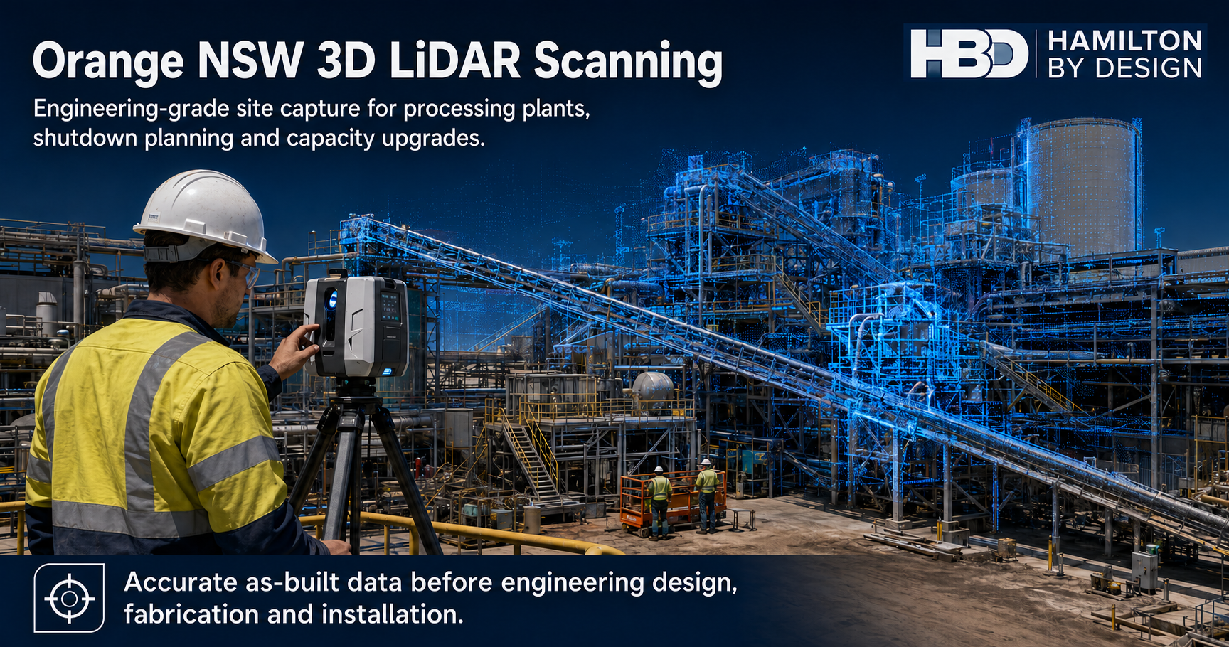
Before a plant upgrade, conveyor modification, chute redesign, structural change or shutdown project can be completed with confidence, the design team needs to know what is actually installed. That is where engineering-grade 3D LiDAR scanning in Orange NSW becomes valuable.
Hamilton By Design provides engineer-led 3D LiDAR scanning for processing plants, mine sites and heavy industrial facilities across Orange NSW and the Central West. The goal is simple: capture accurate as-built site data so engineering design, shutdown planning and capacity upgrade work can be based on real site conditions.
The Problem With Brownfield Processing Plants
Brownfield plants are rarely simple.
Processing plants are changed over many years to keep production running. A platform may be extended. A chute may be modified. A conveyor may be upgraded. Pipework may be rerouted. Guards, access stairs, handrails, tanks, pumps and structural supports may all change as the site grows.
The issue is that the drawings are not always updated after each modification.
This means engineers and contractors can be working from drawings that are incomplete, outdated or missing important site details. For a simple job, this may cause minor delays. For a major shutdown or capacity upgrade, it can create expensive problems.
Common issues include:
- New equipment does not fit the existing space
- Pipework clashes with structural steel
- Platforms or handrails block installation access
- Existing drawings do not match the plant
- Tie-in points are not where the design expected
- Fabricated parts require site rework
- Shutdown tasks take longer than planned
- Workers need to spend more time measuring in live plant areas
In a mining or processing environment, these problems affect more than drafting quality. They affect safety, cost, schedule and production.
Who Needs 3D LiDAR Scanning in Orange NSW?
3D LiDAR scanning is useful for any team that needs accurate site information before making engineering decisions.
For mine operators and processing plant owners, LiDAR scanning provides a reliable record of existing conditions before upgrades or shutdowns begin.
For project engineers, it gives a clear basis for design. Instead of relying only on old drawings, they can work from current site data.
For maintenance supervisors, it helps identify access constraints, equipment locations and workfront issues before trades arrive on site.
For mechanical and structural engineers, the point cloud can support design of chutes, hoppers, conveyors, platforms, walkways, pipe supports, guarding and mechanical equipment layouts.
For fitters, riggers and boilermakers, the benefit is practical. Better site data means fewer surprises during installation.
For drafting teams, the scan can be used to develop CAD models, sections, elevations and fabrication drawings.
In short, 3D scanning helps connect the real plant with the engineering design process.
What Is 3D LiDAR Scanning?
3D LiDAR scanning is a method of capturing real-world site geometry using laser measurement. A terrestrial scanner is set up in multiple positions around the plant. Each scan captures millions of measured points from visible surfaces.
These points are then registered together to create a point cloud.
A point cloud is a digital 3D record of the existing site. It can show structures, conveyors, stairs, tanks, pipework, platforms, equipment, building columns and surrounding access areas.
For engineering work, the point cloud can then be used to create:
- 3D CAD models
- 2D layout drawings
- Sections and elevations
- As-built documentation
- Clash checks
- Equipment layout studies
- Fabrication references
- Shutdown planning information
The key benefit is that the design team can see and measure the real plant without relying only on historical drawings.
Where This Applies Around Orange NSW
Orange NSW is part of the broader Central West / Orange mining and industrial region. The area includes mining operations, processing infrastructure, workshops, materials handling systems and heavy industrial facilities.
3D LiDAR scanning is especially useful in:
- Processing plants
- Concentrator areas
- Conveyor systems
- Transfer stations
- Crusher and screening areas
- Pump and pipework areas
- Tank farms
- Workshops
- Structural platforms
- Access stairs and walkways
- Shutdown workfronts
- Brownfield upgrade areas
The service is not limited to one type of equipment. It is most valuable anywhere the existing plant layout is complex and accurate information is needed before engineering design begins.
How The Scanning Process Works
A typical 3D LiDAR scanning workflow starts with understanding the problem.
The first step is to identify what the client needs to achieve. For example, the project may involve increasing plant capacity, replacing a chute, modifying a conveyor, installing new pipework, upgrading access platforms or checking if new equipment will fit.
Once the work area is understood, the site is scanned from multiple locations. The scanner captures visible geometry from each position. In complex plant areas, multiple scan positions are usually required so the final point cloud has enough coverage around equipment, platforms, pipework and structural steel.
After site capture, the scan data is registered. This means the individual scans are aligned into one coordinated point cloud.
From there, the data can be reviewed and used for engineering work. Depending on the project, Hamilton By Design can provide point cloud files, CAD models, mechanical layouts, structural drafting support, sections, elevations or scan-to-CAD deliverables.
The output depends on the problem being solved.
For some projects, the client may only need point cloud data to support their own design team. For others, they may need a full engineering workflow from scanning through to CAD modelling and drawing production.
Tools That Assist In Solving The Problem
The value of 3D LiDAR scanning comes from both the site capture and the engineering interpretation after the scan.
Common tools used in this workflow include:
| Tool | Purpose |
|---|---|
| FARO Focus Scanner | Captures accurate terrestrial LiDAR scan data on site |
| FARO SCENE | Registers and processes scan data into a point cloud |
| Autodesk ReCap | Converts and manages point cloud files for CAD workflows |
| Navisworks | Supports model review, coordination and clash checking |
| SolidWorks | Mechanical design, modelling and equipment layout development |
| Inventor | Mechanical modelling and fabrication design workflows |
| AutoCAD | 2D layouts, sections, elevations and drafting deliverables |
| Point Cloud Data | Provides the accurate as-built reference for design decisions |
The scanner captures the plant. The software helps organise the data. The engineering process turns that data into decisions.
This is where engineer-led scanning becomes important. A scan is not just a visual record. It needs to be captured and processed in a way that supports the design outcome.
Supporting Capacity Upgrade Projects
One of the strongest reasons to use 3D LiDAR scanning is to support plant upgrades aimed at increasing capacity.
When a site wants to increase throughput, the upgrade may involve larger equipment, modified chutes, conveyor changes, new pipe routes, additional pumps, upgraded platforms or changes to access and maintenance areas.
In a brownfield plant, the available space is usually constrained.
A capacity upgrade can fail or become expensive if the new design does not properly account for what is already installed. A larger chute may clash with a platform. A conveyor upgrade may affect guarding or access. New pipework may run into structural steel. A maintenance access route may be blocked by new equipment.
3D LiDAR scanning helps reduce this risk by confirming the actual site geometry before design and fabrication.
This allows engineers to test the design against the real plant. It also helps contractors understand installation constraints before the shutdown begins.
For capacity upgrade work, LiDAR scanning can help answer questions such as:
- Will the new equipment fit?
- Are there clashes with existing steel or pipework?
- Can the equipment be installed safely?
- Is there enough access for maintenance?
- What needs to be removed or modified before installation?
- Can fabrication be completed with more confidence?
- Are there structural or access issues that need to be addressed early?
By answering these questions before the shutdown, the company can reduce the risk of delays and rework.
The Upside For Workers
For workers, better site data means clearer planning and fewer surprises.
Fitters, riggers, boilermakers and maintenance crews are often the people who discover design problems during installation. If something does not fit, they are left to solve the issue under time pressure, often during a shutdown.
That is not ideal.
Accurate 3D scanning helps move those problems earlier in the process, where they can be dealt with during design rather than during installation.
The upside for workers includes:
- Less time spent measuring complex areas by hand
- Better understanding of access constraints
- Clearer shutdown work packs
- Reduced rework during installation
- Better lift and access planning
- Fewer unexpected clashes
- Improved communication between engineers and trades
- Less time spent in operating plant areas gathering measurements
Good site information also supports safer conversations during planning. Workers can see the work area, understand the constraints and identify issues before the job starts.
The Upside For The Company
For the company, the value is measured in reduced risk.
A processing plant shutdown can be expensive. If a design is wrong, or if fabricated parts do not fit, the cost can grow quickly. Delays can affect production, labour costs, crane time, contractor coordination and commissioning.
3D LiDAR scanning helps reduce these risks by improving the quality of information at the start of the project.
The upside for the company includes:
- Better engineering decisions
- Reduced design uncertainty
- Fewer site clashes
- Less fabrication rework
- More reliable shutdown planning
- Improved contractor coordination
- Better as-built documentation
- Faster concept development
- Stronger governance around design changes
- Better support for future upgrades
The point cloud can also become a useful record for future work. Once captured, it can be reused for planning, design reviews and later modifications.
Why Engineering-Grade Scanning Matters
Not all scanning is the same.
For mining and heavy industry, the scan needs to support engineering decisions. That means the capture process must consider accuracy, coverage, file formats, access constraints, site safety and the final deliverable required by the project.
A basic visual scan may look impressive, but it may not provide the right information for design.
Engineering-grade scanning focuses on practical outputs. The goal is not just to create a digital image of the plant. The goal is to support real engineering work.
That may include modelling a chute, checking conveyor clearances, developing a platform layout, producing fabrication drawings or verifying a shutdown workfront.
Hamilton By Design combines 3D LiDAR scanning with mechanical engineering and CAD capability. This means the scan can be connected directly to the design process.
Example Use Cases
A processing plant in Orange NSW may use 3D LiDAR scanning before replacing a transfer chute. The scan can capture the conveyor, structure, access platforms, surrounding steel and installation constraints. This helps the chute design fit the real plant and reduces the chance of site modifications during installation.
A shutdown team may use scanning to prepare work packs before a major outage. The point cloud can help confirm access, equipment positions and nearby clashes.
A project engineer may use scanning before a capacity upgrade. The scan can help test whether larger equipment or modified conveyors will fit within the existing plant.
A structural engineer may use the point cloud to check platform layouts, stairs, handrails and support locations before producing design documentation.
A drafting team may use scan-to-CAD workflows to create updated layouts where existing drawings are missing or unreliable.

For brownfield processing plants in Orange NSW and the Central West, accurate as-built information is one of the most important inputs into good engineering design.
Old drawings, incomplete records and years of site modifications can create risk before a project even starts. 3D LiDAR scanning helps solve that problem by capturing the real plant and turning it into usable engineering data.
For workers, this means clearer planning, fewer surprises and better shutdown preparation.
For companies, it means reduced rework, better design confidence, stronger project governance and improved support for capacity upgrades.
Hamilton By Design provides engineering-grade 3D LiDAR scanning in Orange NSW for processing plants, shutdown planning, structural upgrades and accurate as-built documentation. The result is better information before design, fabrication and installation begin.
Talk to Us – Contact Us
Our clients:


