Gold and copper processing plants are difficult places to measure accurately. They often include dense pipework, conveyors, chutes, tanks, platforms, pumps, valves, handrails, cable trays and structural steel, all working together in a tight operating environment. Over time, these plants are modified during shutdowns, maintenance works and production upgrades. The result is that the real plant may no longer match the original drawings.
For engineers, maintenance planners and project teams, this creates a major problem. If the existing site information is incomplete or wrong, design decisions are made on assumptions. That can lead to clashes, poor access, rework, fabrication errors and costly delays during shutdowns.
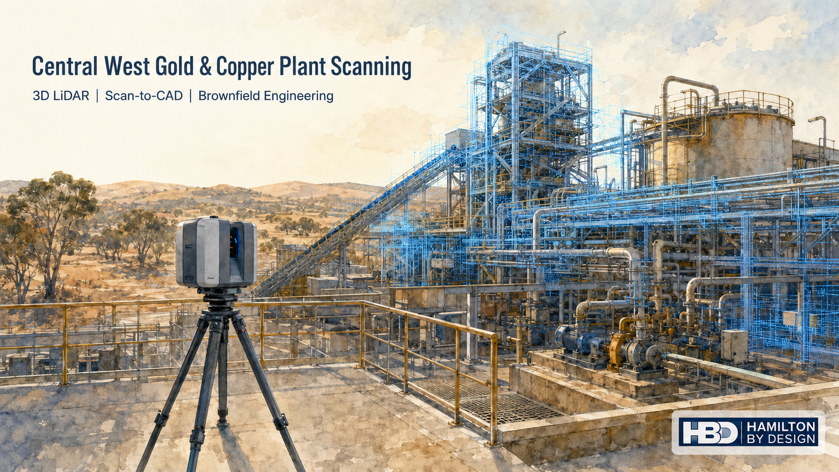
Hamilton By Design provides engineering-grade 3D LiDAR scanning for gold and copper processing facilities across Orange, Blayney, Bathurst, Parkes and the wider Central West NSW region. Our scanning workflow helps capture accurate plant, pipework and structural data so engineers can plan upgrades, modifications and shutdown works with greater confidence.
For local engineering support in the region, Hamilton By Design also provides 3D Scanning Engineering in Orange for industrial, mining, infrastructure and processing plant projects.
Why Gold and Copper Processing Plants Are Hard to Measure
Gold and copper processing infrastructure is rarely simple. A typical plant area may include crushing, grinding, flotation, concentrate handling, dewatering, pumping systems, pipe racks, access platforms and structural supports. These systems are often layered around one another and squeezed into existing plant envelopes.
Manual measurement can be slow and difficult in these environments. It may require repeated access to elevated areas, congested walkways, shutdown zones or restricted plant areas. Even with careful site work, it is easy to miss critical details such as flange positions, pipe offsets, structural interferences, access clearances, equipment footprints or support steel locations.
The issue becomes more serious when fabrication is involved. A pipe spool, chute liner, access platform or replacement support frame may look correct on a drawing, but if the existing plant has moved, been modified or was never built exactly as drawn, the new item may not fit.
3D LiDAR scanning helps reduce this risk by capturing the real site condition before design and fabrication decisions are made.
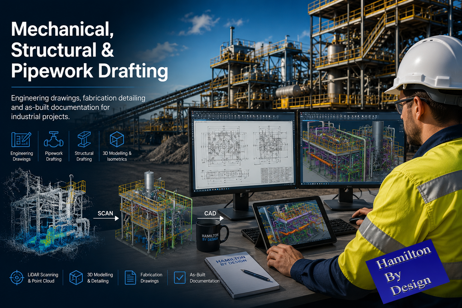
What 3D LiDAR Scanning Captures
A 3D LiDAR scanner captures millions of measurement points from the visible plant environment. These points form a digital point cloud that can be used to measure, model and verify existing site conditions.
In a Central West gold or copper processing plant, 3D scanning can be used to capture:
- Pipework and pipe racks
- Pumps, motors and drive arrangements
- Tanks, vessels and hoppers
- Conveyors and transfer points
- Chutes, guards and skirt systems
- Platforms, stairs, ladders and handrails
- Structural steel frames and supports
- Floor levels, slab edges and equipment bases
- Existing equipment footprints
- Access restrictions and maintenance zones
- Building envelopes and surrounding infrastructure
This information can then be used by engineers, drafters, fabricators and maintenance teams to make better decisions before work reaches site.
Hamilton By Design’s broader Engineering-Grade LiDAR Scanning service is focused on capturing scan data that can be used for real engineering decisions, not just visual reference.
Supporting Orange and Central West NSW Processing Projects
Orange and the Central West NSW region support major mining, processing, agricultural, industrial and infrastructure activity. For gold and copper processing plants in this region, accurate site information is especially important because many projects are brownfield upgrades rather than new greenfield construction.
Brownfield projects are difficult because the design has to fit around what already exists. Existing plant may have been modified over many years. Old drawings may be missing, incomplete or no longer correct. Access may be limited. The new work may need to be installed during a short shutdown window.
Hamilton By Design can support Central West NSW projects involving:
- Processing plant upgrades
- Conveyor and chute modifications
- Pipework replacement
- Pump and tank modifications
- Structural platform upgrades
- Access and maintenance improvements
- Scan-to-CAD modelling
- Shutdown planning
- Fabrication drawing preparation
- Clash checking and design verification
The aim is to capture the site once, process the information properly and give the project team data they can actually use.
Turning Site Reality into Engineering Data
The value of 3D scanning is not only in the scan itself. The real value comes from turning the scan into useful engineering information.
A point cloud can be used to check clearances, measure distances, create sections, confirm equipment positions and model existing infrastructure. From there, the data can support CAD modelling, general arrangement drawings, fabrication design and installation planning.
For example, if a processing plant needs a pipework modification, the scan can help confirm the existing pipe route, flange orientation, valve access, nearby structural steel and installation clearances. If a chute or transfer point needs work, the scan can help confirm belt position, head pulley geometry, surrounding access platforms and support steel. If a platform needs upgrading, the point cloud can help verify levels, columns, handrails and connection points.
For projects where existing conditions are uncertain, Hamilton By Design’s 3D LiDAR Scanning for As-Built & Brownfield Engineering provides a practical workflow for capturing the real site before design decisions are locked in.
How the Scanning Process Works
A typical Central West plant scanning project starts with a short discussion about the problem being solved. Some clients need a registered point cloud only. Others need CAD modelling, drawings, sections, elevations or fabrication support.
The usual workflow includes:
- Review the plant area and project objective
- Plan scanner locations and site access requirements
- Complete LiDAR scanning of the required area
- Register the scan data into a single point cloud
- Review scan coverage and data quality
- Export point cloud files such as E57, RCP or RCS
- Complete scan-to-CAD modelling if required
- Prepare drawings, sections or engineering deliverables if required
This process gives the project team a reliable record of existing conditions. It also reduces the need for repeated site visits, which can be important when access is limited or the plant is operating.
Tools Used to Assist the Work
Hamilton By Design uses scanning, modelling and drafting tools suited to mechanical and structural plant work. Depending on the project, the workflow may include FARO LiDAR scanning, FARO SCENE, Autodesk ReCap, Navisworks, SolidWorks, Inventor and AutoCAD.
Common deliverables may include:
- Registered point clouds
- E57, RCP, RCS or LAS files
- 3D CAD models
- General arrangement drawings
- Sections and elevations
- Pipework layouts
- Equipment set-out drawings
- Fabrication drawings
- Clash review models
- As-built documentation
The purpose is to make the scan useful for engineering, fabrication and installation. A point cloud may be valuable on its own, but many clients need the next step: clear CAD geometry, practical drawings and engineering interpretation.
Hamilton By Design also provides 3D LiDAR Scanning & Digital QA Verification for projects where existing or fabricated components need to be checked against design requirements.
Reducing Shutdown and Fabrication Risk
Shutdown work is expensive because the available window is usually short. Labour, cranes, scaffolding, access equipment, fabrication, transport and production downtime all need to line up. If a fabricated item does not fit, the cost is rarely limited to the part itself. The real cost is the delay, rework and disruption around it.
3D scanning can help reduce this risk before shutdown work begins. It allows the project team to check the existing plant condition early and ask practical questions such as:
- Does the proposed pipe route fit?
- Are the existing drawings still reliable?
- Is there enough access for installation?
- Will the new chute clear the existing structure?
- Are there clashes with handrails, cable trays or supports?
- Can the replacement item be modelled before removal?
- What needs to be verified before fabrication starts?
For processing plants, this is where scan data becomes a risk-reduction tool. It helps move uncertainty from site into the design stage, where problems are cheaper and easier to solve.
Why Use an Engineering-Led Scanning Provider?
Not all scanning services are the same. A scanner can capture geometry, but engineering judgement helps determine what needs to be captured, how the information will be used and which details matter.
Hamilton By Design combines 3D LiDAR scanning with mechanical engineering, CAD modelling and drafting experience. This means the scan is planned around the final outcome, whether that is a point cloud, a CAD model, a pipework layout, a platform drawing, a chute design or a shutdown planning model.
For gold and copper processing facilities, this is important because the site is not just a shape to be recorded. It is an operating plant with mechanical systems, access constraints, maintenance requirements and fabrication realities.
Engineering-led scanning helps ensure the right areas are captured, the correct interfaces are considered and the final deliverables support real project decisions.
FAQs
What is 3D scanning used for in a gold or copper processing plant?
3D scanning is used to capture accurate existing conditions of plant, pipework, conveyors, chutes, tanks, platforms, structural steel and access systems. The scan data can then support engineering design, shutdown planning, fabrication, clash checking and as-built documentation.
Why is 3D scanning better than manual measurement?
Manual measurement can be slow, incomplete and difficult in congested plant areas. 3D scanning captures millions of points across the visible environment, giving engineers a more complete digital record of the site. It also reduces the need for repeated site visits.
Can 3D scanning help with shutdown planning?
Yes. Scanning can help project teams verify existing conditions before a shutdown begins. This can reduce the risk of fabricated parts not fitting, clashes with existing plant, access problems and unexpected site issues.
What areas of a processing plant can be scanned?
Typical areas include pipe racks, pump bays, conveyors, transfer stations, chutes, tanks, platforms, stairs, handrails, structural steel, equipment bases and surrounding access areas.
What file formats can be supplied?
Depending on the project, point cloud data can be supplied in formats such as E57, RCP, RCS or LAS. CAD deliverables may include DWG, DXF, STEP, SAT, Parasolid, SolidWorks or Inventor files.
Can the scan be converted into CAD drawings?
Yes. Scan data can be converted into CAD models, general arrangement drawings, sections, elevations, pipework layouts, fabrication drawings and as-built documentation.
Is this suitable for brownfield plant upgrades?
Yes. Brownfield upgrades are one of the strongest uses for 3D scanning. It helps engineers understand what is already built before designing new work around it.
Does Hamilton By Design service Orange and Central West NSW?
Yes. Hamilton By Design supports engineering, 3D scanning, scan-to-CAD and drafting work across Orange, Blayney, Bathurst, Parkes and the wider Central West NSW region.
Central West Gold and Copper Plant Scanning
For gold and copper processing facilities across Orange and Central West NSW, 3D scanning provides a practical way to capture complex existing infrastructure before engineering work begins. It helps project teams reduce manual measurement, improve design confidence and plan upgrades with better information.
Hamilton By Design can assist with plant scanning, scan-to-CAD modelling, pipework verification, structural drafting, conveyor and chute upgrades, shutdown planning and brownfield engineering support.
If your team is planning work around a Central West NSW processing plant, 3D LiDAR scanning can help turn a complicated site into reliable engineering data before the job reaches fabrication, shutdown or site installation.
Talk to Us – Contact Us
Our clients: