


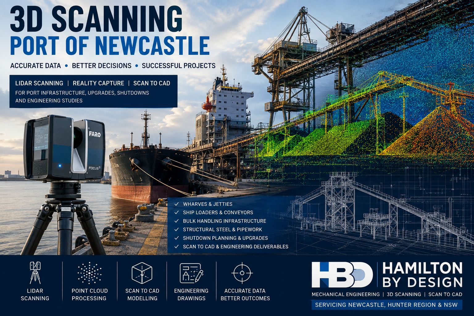
3D Scanning Port of Newcastle
Engineering-Grade LiDAR Scanning for Ports, Terminals and Marine Infrastructure.
Hamilton By Design provides engineering-grade 3D scanning at the Port of Newcastle for wharves, terminals, conveyors, ship-loading equipment, structural steel, pipework and other marine infrastructure.
This page is specifically focused on port and terminal projects. It complements the broader 3D Laser Scanning Newcastle service and the separate Scan to BIM Newcastle & Hunter service without targeting the same primary search intent.
Our engineer-led workflow can support:
- Port infrastructure upgrades
- Brownfield engineering
- Shutdown preparation
- Existing-condition surveys
- Scan to CAD modelling
- Fabrication and fit-up checks
- Clash detection
- Engineering studies
- As-built verification
- BIM and asset-documentation projects
The objective is to give engineers, terminal operators, contractors and fabricators accurate information about what is physically installed before design or construction begins.
3D Scanning for Port of Newcastle Projects
Port facilities contain interconnected structural, mechanical, civil and marine systems that can be difficult to measure using conventional methods.
Hamilton By Design can capture visible and accessible infrastructure such as:
- Wharf decks and structural framing
- Berths and terminal facilities
- Conveyors and transfer stations
- Ship loaders and unloaders
- Chutes, hoppers and bins
- Crane rails and crane interfaces
- Structural-steel platforms
- Pipe racks and process pipework
- Maintenance-access systems
- Equipment foundations
- Marine-loading equipment
- Rail and road interfaces
- Workshops and service areas
- Existing utilities and services
The Port of Newcastle supports multiple cargo types and includes port precincts, berths, terminals and landside infrastructure serving bulk, general and project cargo activities.
A coordinated point cloud provides a measurable digital record of the project area and the relationships between surrounding assets.
How This Page Differs from Scan to BIM Newcastle & Hunter
The Scan to BIM Newcastle & Hunter page focuses on converting captured buildings, plants and infrastructure into organised BIM models for design, coordination, construction and asset-management workflows.
This 3D Scanning Port of Newcastle page has a different purpose.
Its primary focus is:
- Site capture within port and terminal environments
- Wharf and marine infrastructure
- Materials-handling equipment
- Port shutdowns and upgrades
- Engineering point clouds
- Scan to CAD
- Fabrication and installation support
- Existing-condition engineering studies
Where a project requires a structured BIM deliverable after scanning, the Scan to BIM Newcastle & Hunter service can form the next stage of the workflow.
Recommended content relationship
3D Scanning Port of Newcastle
Capture the port facility and produce accurate point-cloud data.
Scan to CAD
Convert selected structures and equipment into practical engineering geometry.
Scan to BIM Newcastle & Hunter
Develop organised BIM information for coordination, documentation or asset-management purposes.
This separation helps each page answer a different search query and reduces the risk of SEO cannibalisation.
Why Accurate Port Site Capture Matters
Port infrastructure changes throughout its operating life.
Equipment and structures may have been:
- Repaired
- Reinforced
- Replaced
- Relocated
- Extended
- Distorted
- Supplemented with additional steelwork
- Modified without drawing updates
Original drawings may provide useful historical information, but they do not always represent the current site condition.
Engineering-grade LiDAR scanning records the visible facility as it exists at the time of capture.
The data can help identify the locations and relationships of:
- Structural members
- Pipework
- Conveyor equipment
- Access platforms
- Mechanical assets
- Electrical services
- Crane systems
- Equipment foundations
- Wharf-mounted services
- Installation routes
This provides a stronger basis for engineering than relying solely on isolated measurements or outdated drawings.
Port Terminals and Cargo-Handling Infrastructure
Terminal projects often involve complex interfaces between machinery, structural steel, road vehicles, rail systems, services and marine infrastructure.
3D scanning can support projects associated with:
- Bulk-material terminals
- General-cargo facilities
- Project-cargo areas
- Conveyor-loading systems
- Stockyard interfaces
- Rail loading and unloading
- Wharf-side equipment
- Truck receival areas
- Storage facilities
- Maintenance zones
- Operational-access areas
The scan scope can be limited to the particular work area and critical interfaces, avoiding unnecessary capture and modelling.
Wharf and Marine-Infrastructure Scanning
Wharf projects can involve restricted access, irregular geometry, tidal conditions and hazards associated with working near water.
LiDAR scanning can document visible geometry relating to:
- Wharf decks
- Structural framing
- Crane rails
- Fender-support structures
- Bollards
- Mooring equipment
- Handrails and barriers
- Access ladders
- Service trenches
- Pipework
- Loading systems
- Equipment bases
- Adjacent road and rail areas
The resulting point cloud can support engineering design, maintenance planning, modification projects and existing-condition documentation.
Conveyor and Bulk-Materials Infrastructure
Newcastle and the Hunter Region contain extensive mining, materials-handling and industrial infrastructure. Hamilton By Design already provides engineering-grade scanning and mechanical-engineering support for conveyors, transfer stations, chutes and brownfield mining assets throughout the region.
Port scanning can include:
- Belt conveyors
- Transfer towers
- Transfer chutes
- Hoppers
- Feeders
- Bins
- Ship loaders
- Structural supports
- Walkways
- Conveyor guarding
- Dust-extraction systems
- Loading and discharge points
- Maintenance platforms
These environments are often elevated, congested and difficult to document comprehensively with manual measurements.
A registered point cloud records the broader spatial relationship between the equipment and its surroundings.
3D Scanning for Port Infrastructure Upgrades
Port infrastructure upgrades are commonly undertaken within existing operating facilities.
New components may need to fit around:
- Existing structural steel
- Pipework
- Cable trays
- Handrails
- Mechanical equipment
- Conveyor components
- Traffic routes
- Crane operating areas
- Maintenance envelopes
- Existing services
Typical applications include:
- Conveyor replacements
- Transfer-chute upgrades
- Ship-loader modifications
- New access platforms
- Pipework alterations
- Crane-access improvements
- Equipment relocations
- Dust-control upgrades
- Structural-steel additions
- Guarding improvements
- New foundations
- Wharf-service upgrades
- Terminal-layout changes
The point cloud can be combined with proposed CAD geometry to evaluate fit, access and constructability before work reaches the site.
Shutdown Planning and Constructability
Port shutdown periods can involve strict time limits, multiple contractors and significant operational consequences.
Unexpected site conditions may result in:
- Installation delays
- Additional crane time
- Site cutting and welding
- Fabrication modifications
- Extended isolations
- Additional labour
- Increased safety exposure
- Delayed return to operation
Pre-shutdown scanning can help project teams prepare:
- Installation sequences
- Demolition plans
- Lift studies
- Removal-path studies
- Laydown arrangements
- Work packs
- Temporary-access requirements
- Component fit checks
- Clash reviews
- Contractor briefings
The point cloud also enables off-site teams to examine the work area without repeatedly returning to the terminal.
Scan to CAD for Port Engineering
The point cloud can be used directly for measurements and spatial reviews, or selected geometry can be converted into CAD.
Scan-to-CAD deliverables may include:
- Structural-steel models
- Conveyor models
- Chute and hopper geometry
- Mechanical-equipment models
- Pipework models
- Equipment envelopes
- Platform and access models
- Wharf layouts
- General-arrangement drawings
- Plans, sections and elevations
- Existing-condition drawings
- Installation-planning models
The modelling scope should reflect the project objective.
A fabrication project may require detailed connection geometry, while an early engineering study may require only simplified envelopes and surrounding structural interfaces.
Hamilton By Design’s national engineering-grade scanning workflow is designed to produce geometry that supports modification, decision-making and fabrication—not just visual point-cloud data.
When Scan to BIM Is the Better Deliverable
Scan to BIM may be appropriate where the project requires:
- Organised building or infrastructure elements
- Structured model information
- Design-team coordination
- Building-services coordination
- Construction documentation
- Asset-management information
- Long-term digital records
- Revit-based project delivery
For these requirements, project teams should also review Scan to BIM Newcastle & Hunter.
For mechanical equipment, conveyors, chutes, pipework and fabrication interfaces, Scan to CAD or engineering-specific modelling may be more appropriate than a full BIM model.
Fabrication and Fit-Up Support
New fabricated components often need to connect accurately to existing infrastructure.
3D scanning can support:
- Structural platforms
- Walkways and stairs
- Handrails
- Pipe spools
- Chutes and hoppers
- Conveyor modifications
- Machine guards
- Equipment supports
- Ductwork
- Access covers
- Replacement steelwork
- Retrofit frames
Hamilton By Design also provides a dedicated 3D Scanning for Fabrication Newcastle service covering structural steel, pipework, conveyors, machinery and connection points.
This service should be linked from the port page where the user’s primary objective is fabrication or fit-up rather than general port reality capture.
Clash Detection Before Construction
Proposed equipment or steelwork can be positioned within the point cloud before fabrication and installation.
Potential conflicts may involve:
- Structural members
- Pipework
- Cable trays
- Conveyor equipment
- Handrails
- Crane envelopes
- Vehicle routes
- Maintenance-removal paths
- Existing services
- Wharf-edge equipment
- Installation access
Early clash identification allows the design to be reviewed while changes are still relatively straightforward.
Engineering Studies Supported by Port Scanning
Port and marine point-cloud data can support:
- Existing-condition studies
- Drawing-verification studies
- As-built assessments
- Dimensional inspections
- Mechanical-access studies
- Structural-arrangement reviews
- Equipment-clearance studies
- Constructability assessments
- Wear and erosion studies
- Deformation assessments
- Refurbishment planning
- Reverse-engineering studies
- Damage documentation
- Incident investigations
The capture plan should be developed around the questions the engineering study needs to answer.
As-Built and Installation Verification
After construction or installation, selected areas may be rescanned and compared with the design model.
This can help review:
- Installed position
- Structural alignment
- Equipment orientation
- Pipe routing
- Clearances
- Construction tolerances
- Variations from design
- Final as-built condition
Where the project requires a structured asset or BIM record, the verified information can then feed into the Scan to BIM workflow.
Our Port of Newcastle Scanning Workflow
1. Define the Engineering Purpose
Before scanning, we establish:
- Project objective
- Required capture area
- Critical interfaces
- Required accuracy
- Point-cloud deliverables
- CAD or BIM requirements
- Coordinate requirements
- File formats
- Required level of detail
2. Plan Site Access and Safety
Port scanning may require consideration of:
- Terminal inductions
- Maritime-security controls
- Work permits
- Vessel movements
- Heavy vehicles
- Crane operations
- Operating conveyors
- Work near water
- Exclusion zones
- Shutdown requirements
- Communication with operations
3. Capture the Site
Multiple scanner positions are established to capture the work area and reduce occlusions.
Priority is given to:
- Tie-in points
- Structural connections
- Equipment clearances
- Pipework interfaces
- Access paths
- Installation constraints
- Areas required for modelling
4. Register and Review the Point Cloud
The individual scans are aligned into a coordinated dataset and reviewed for:
- Registration quality
- Coverage
- Noise
- Missing areas
- Critical interfaces
- Dimensional consistency
- Coordinate control
5. Develop the Required Deliverables
Depending on the scope, the point cloud may be used for:
- Direct measurement
- Engineering review
- Scan to CAD
- Scan to BIM
- Existing-condition drawings
- Fabrication modelling
- Clash detection
- As-built documentation
Available Deliverables
Project deliverables may include:
- Registered point clouds
- E57 files
- RCP and RCS files
- LAS files
- AutoCAD DWG drawings
- DXF files
- SolidWorks models
- Autodesk Inventor models
- STEP files
- SAT files
- Parasolid files
- Navisworks coordination models
- Revit or BIM deliverables where scoped
- General-arrangement drawings
- Plans, sections and elevations
- Existing-condition reports
- Fabrication-support drawings
- As-built records
Engineer-Led Reality Capture
The value of a scanning project depends on capturing the geometry needed for the engineering outcome.
Hamilton By Design combines:
- Mechanical-engineering experience
- Terrestrial LiDAR scanning
- Point-cloud registration
- Scan to CAD
- Scan to BIM coordination
- SolidWorks modelling
- AutoCAD drafting
- Structural and mechanical drafting
- Fabrication knowledge
- Brownfield-design experience
- Shutdown planning
This integrated workflow helps prevent a common problem: collecting a large point cloud without capturing the specific interfaces needed by the design team.
Port of Newcastle and Hunter Areas Serviced
Hamilton By Design can support projects throughout:
- Port of Newcastle
- Carrington
- Mayfield
- Kooragang Island
- Walsh Point
- Stockton
- Wickham
- Tighes Hill
- Mayfield West
- Newcastle
- Lake Macquarie
- Maitland
- Hunter Valley
- Regional New South Wales
Site attendance remains subject to the requirements of the relevant terminal operator, tenant, asset owner or site controller.
Frequently Asked Questions
Is this the same as Scan to BIM Newcastle & Hunter?
No. This page focuses on scanning port and terminal infrastructure and producing engineering point clouds or Scan-to-CAD information.
The Scan to BIM Newcastle & Hunter page focuses on developing organised BIM models for design coordination, documentation and asset-management workflows.
Can you scan conveyors and ship-loading equipment?
Yes. LiDAR scanning can capture conveyors, transfer stations, chutes, ship loaders, structural supports, platforms and surrounding infrastructure.
Can scanning occur while the terminal remains operational?
Often, yes. Scanning is non-contact, but access must be coordinated around terminal operations, traffic, vessels, cranes, machinery and exclusion zones.
Can the scan be converted into SolidWorks or AutoCAD?
Yes. Selected geometry can be developed into SolidWorks, Inventor, STEP, SAT, Parasolid, DWG or DXF deliverables, depending on the agreed scope.
Do we need a complete BIM model?
Not necessarily. Port mechanical and fabrication projects may be better served by a registered point cloud or targeted Scan-to-CAD model.
A complete BIM model should be specified only where the project requires structured information and coordinated BIM deliverables.
Can existing drawings be checked against the scan?
Yes. Existing drawings and CAD models can be compared with the point cloud to identify differences between documented and measured conditions.
Can the data support fabrication?
Yes. Where fabrication modelling and drawings are included in the scope, measured site geometry can support fit-up checks and fabrication documentation.
What file formats are available?
Common formats include E57, RCP, RCS, LAS, DWG, DXF, STEP, SAT, Parasolid, SolidWorks, Inventor and selected BIM formats.
Discuss a Port of Newcastle 3D Scanning Project
Hamilton By Design provides engineer-led 3D scanning for Port of Newcastle infrastructure, supporting wharves, terminals, conveyors, ship-loading systems, structural steel, pipework and brownfield upgrades.
The service can be tailored around the required outcome, whether the project needs:
- A registered engineering point cloud
- Existing-condition drawings
- Targeted Scan-to-CAD modelling
- Fabrication and fit-up support
- Shutdown planning
- Clash detection
- As-built verification
- A coordinated Scan-to-BIM deliverable
Contact Hamilton By Design to discuss the required capture area, accuracy, access conditions and engineering deliverables.