Lidar Scanning & Engineering in Cairns

Where Tropical Ecosystems, Marine Industry & Industrial Precision Converge

Cairns is not just a gateway to reefs and rainforests โ€” itโ€™s a strategic hub for marine engineering, coastal infrastructure, environmental projects and remote-region logistics. With its proximity to the Great Barrier Reef, the Wet Tropics rainforest, a busy regional port, defence facilities and frequent heavy industrial and marine maintenance requirements, Cairns demands precision, flexibility and deep engineering expertise.

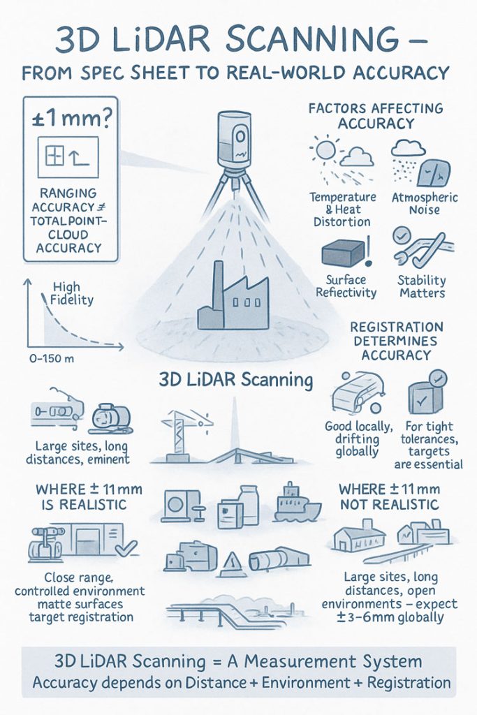
At Hamilton By Design, we understand those needs. Our offerings โ€” 3D LiDAR laser scanning, mechanical and structural engineering, 3D modelling, and fabrication-ready drafting โ€” are designed to meet the unique challenges of Northern Queensland. Whether itโ€™s a marine-grade fabrication yard, a coastal infrastructure project, a remote-region logistยญics facility or an environmental structure upgrade โ€” we deliver accuracy, compliance and quality from start to finish.


Why Cairns Is a Special Case for Engineering & Digital Surveying

Cairns combines tropical climate, marine exposure, rainforest-adjacent terrain, heritage sensitivity and strategic infrastructure in ways few other regional Australian cities do. Key aspects include:

  • Coastal and marine infrastructure needing resistance to corrosion, saltwater, tidal influence and cyclone-proofing.
  • Environmental and ecological constraints thanks to proximity to reef and rainforest โ€” making accurate as-built documentation, impact assessments, and careful planning essential.
  • A busy port, marine services and vessel maintenance sector โ€” requiring complex structural, mechanical and fabrication-grade precision.
  • Remote-area supply chains and logistics hubs serving Cape York, Torres Strait, Gulf communities and mining / remote-site projects.
  • Mixed infrastructure: commercial, marine, industrial, tourism-facing โ€” often on tight schedules due to weather, seasonal demand or regulatory windows.

In short: for projects in Cairns, thereโ€™s no room for guesswork. Whatโ€™s needed is digital accuracy, detailed planning and structured engineering from scanning to delivery.


3D LiDAR Laser Scanning โ€” The Foundation for Reliable Project Delivery

Most coastal, marine or tropical-region facilities have complexities that challenge traditional surveying: uneven terrain, tide-influenced shorelines, dense vegetation, complex plant and structural geometry, and legacy infrastructure.

Our 3D LiDAR laser scanning solves these problems by capturing an exact โ€œdigital twinโ€ of the existing environment โ€” down to millimetre precision. That means:

  • accurate as-built geometry of buildings, wharfs, vessels, platforms, terrain, and utilities
  • precise mapping of structural steel, supports, pipework, stairs, and foundations
  • detailed spatial data for marine and coastal assets โ€” including elevation, overhangs, clearances, and water-line references
  • baseline data for planning upgrades, maintenance, or compliance audits

For any project where precision is critical โ€” from marine maintenance to coastal-infrastructure retrofits โ€” LiDAR scanning provides the data foundation you can trust.

Learn more about our scanning service: 3D Laser Scanning


3D Modelling & Drafting: Turning Point-Clouds into Work-Ready Designs

Once the scan is complete, Hamilton By Design converts raw point clouds into intelligent 3D CAD models and fabrication-ready drawings. This step is critical when building or refurbishing:

  • marine-grade structural supports and frameworks
  • coastal infrastructure (jetties, boat ramps, wharf extensions)
  • buildings, sheds, warehouses with corrosion-resistant materials
  • processing facilities for marine, aquaculture or remote-region supply
  • environmental or utility infrastructure sensitive to terrain and waterline

We provide:

  • accurate mechanical and structural models
  • general-arrangement (GA) drawings
  • detailed fabrication drawings, isometrics, BOMs
  • interference / clash detection before any welding or cutting begins
  • digital documentation for regulatory compliance, QA and future maintenance

With this workflow, you get clean, precise, build-ready plans โ€” essential for tropical marine environments where mistakes are expensive.


Engineering Services for Cairnsโ€™ Unique Industrial & Marine Needs

From marine maintenance to coastal infrastructure, Cairns projects often involve corrosion resistance, flooding, cyclone-proofing, load-bearing structures, and complex geometry. Hamilton By Design offers:

  • structural design for coastal & marine facilities (jetties, piers, decks, frames)
  • stress, vibration, fatigue and load capacity analysis (especially for salt-water, tidal and dynamic loads)
  • mechanical design for processing plants, workshops, offshore-support equipment
  • piping, ducting, and pressurised systems โ€” especially in marine, water treatment or aquaculture facilities
  • environmental compliance support โ€” ensuring designs accommodate tidal ranges, erosion, storm surges, vegetation and terrain

Whether for a harbour-side workshop, a marine-service shed, or remote-region logistics facility, we deliver structural integrity, regulatory compliance, and practical build plans.


Real-World Use Cases for Cairns โ€” Where Hamilton By Design Adds Value

Marine Infrastructure & Vessel Maintenance

For shipyards, vessel refits, port-side maintenance or marine-support infrastructure, accurate spatial data + structural modelling is critical. LiDAR scanning ensures all geometry is captured โ€” ideal for planning upgrades, retrofits or new builds with tight tolerances.

Coastal & Reef-Adjacent Infrastructure

Marine-environment facilities, boardwalks, eco-tourism builds, boat ramps, jetties or reef-support structures benefit from precise bathymetric / terrain-adjacent scans, corrosion-resistant design, and structural integrity.

Remote-Region Logistics & Utility Facilities

Supplying remote Northern Queensland or island communities often involves complex logistics, tight installation windows and harsh environmental conditions. Digital modelling + drafting supports efficient, low-risk builds and maintenance.

Industrial Workshops & Fabrication Yards

Whether for marine fabrication, equipment repair, small-scale processing, or heavy-duty maintenance โ€” these facilities benefit from accurate as-built documentation, clash detection, and fabrication-ready drawings before work begins.

Environmentally Sensitive / Compliance Projects

Projects near rainforest or reef zones often require strict regulatory compliance, environmental impact design, storm-water management, erosion control, and terrain-aware structural planning. Our engineering services integrate these factors from the start.


Hamilton By Design logo displayed on a blue tilted rectangle with a grey gradient background

Why Cairns & Hamilton By Design โ€” The Perfect Combination

Cairnsโ€™ unique blend of tropical climate, marine exposure, environmental sensitivity, remote-region logistics and industrial demand means projects here arenโ€™t simple. They require precision, compliance, resilience, and planning for extremes.

Hamilton By Design brings together:

  • 3D LiDAR laser scanning for accurate as-built documentation
  • 3D modelling & drafting to turn scan data into build-ready plans
  • Mechanical & structural engineering tailored to marine, coastal and tropical environments
  • End-to-end project documentation for compliance, QA and future maintenance

Whether youโ€™re building a marine maintenance facility, refurbishing coastal infrastructure, servicing remote-region supply chains, or building a fabrication workshop โ€” with Hamilton By Design, you get reliability, clarity and quality.

Our Clients

Name
Would you like us to arrange a phone consultation for you?

Townsvilleโ€™s Industrial Frontier

Townsvilleโ€™s Industrial Frontier โ€” How 3D LiDAR, Digital Engineering and Modern Drafting Are Powering North Queensland Projects

Townsville is much more than a tropical coastal city โ€” itโ€™s the beating industrial heart of Northern Australia. As the largest urban centre north of the Sunshine Coast, Townsville connects mining, maritime, defence, manufacturing and export logistics in a way few other regional centres can.

With rapid growth across the port, military infrastructure, mining-supply networks, marine services and export facilities, the region demands precision, reliability and future-ready engineering solutions. Thatโ€™s where Hamilton By Design steps in โ€” offering tailored 3D LiDAR laser scanning, comprehensive mechanical and structural engineering, advanced 3D modelling, and fabrication-ready drafting to meet Townsvilleโ€™s unique and complex needs.

If youโ€™re planning a warehouse expansion, a plant upgrade, port logistics facility, or maintenance overhaul โ€” we give you data-driven confidence from day one.


Why Townsville Needs Digital Engineering & 3D Scanning

Townsville stands out among Australian regional cities because of its diverse economy and heavy industrial footprint:

  • It hosts one of Australiaโ€™s busiest multi-cargo seaports โ€” Port of Townsville โ€” handling minerals, metals, bulk exports, container freight, and supporting exports from Western and North-West Queensland mining regions.
  • It supports major mining supply chains, metal-refining operations and logistics infrastructure across the region.
  • It hosts the largest defence garrison in northern Australia โ€” Lavarack Barracks โ€” plus associated military, infrastructure and support-facility requirements.
  • Townsvilleโ€™s urban and industrial centre sits beside a sensitive coastal environment, with proximity to the Great Barrier Reef and marine ecosystems โ€” meaning infrastructure must often balance heavy-duty utility with environmental and spatial constraints.

This mix of heavy industry, maritime logistics, defence requirements, and environmental sensitivity demands more than standard surveys โ€” it needs digital accuracy, thorough engineering, careful planning and future-ready documentation.


3D LiDAR Laser Scanning โ€” The Foundation of High-Integrity Projects

When dealing with port terminals, refinery installations, mining supply warehouses, defence facilities, or heavy-machinery workshops, inaccurate site measurements can be costly โ€” leading to misaligned equipment, interference, regulation compliance risks, fabrication errors or rework.

At Hamilton By Design, our 3D LiDAR laser scanning service captures full as-built environments with high precision, including:

  • structural steel, supports and framing
  • complex pipework, conveyors, fittings
  • terrain, civil features and existing utilities
  • machinery layout, clearances, and tie-in points

The result: a complete, millimetre-accurate digital record of your siteโ€™s geometry โ€” ideal for analysis, retrofits, expansions or maintenance.

Discover our full capabilities here: 3D Laser Scanning
https://www.hamiltonbydesign.com.au/home/3d-lidar-scanning-digital-quality-assurance/3d-laser-scanning/

For Townsville clients, this means fewer shutdowns, safer project planning, faster fabrication, and minimized risk of unexpected clashes or construction rework.


From Point Cloud to Precision โ€” 3D Modelling, Drafting & Engineering

Once the scan is complete and point-cloud data processed, we build intelligent 3D models and fabrication-ready documentation:

  • mechanical and structural CAD models (existing and proposed)
  • general arrangement (GA), detailed drawings, isometrics and BOMs
  • clash detection and interference checking before fabrication or retrofit
  • layout optimisation for workflow, maintenance access, and safety compliance
  • digital archives for future maintenance or expansion

For heavy-duty environments such as port facilities, refineries, warehouses, defence-related infrastructure or mining supply workshops โ€” having accurate 3D models eliminates costly guesswork and supports efficient execution.

In short: we give you digital twins, not just drawings.


Engineering Support for Townsvilleโ€™s Key Industries

Townsvilleโ€™s industrial profile spans mining, export logistics, maritime, defence, metals processing and large-scale fabrication โ€” each with its own engineering demands.

Hamilton By Design offers:

  • structural assessments (platforms, supports, frames, foundations) for retrofits or new installations
  • mechanical layout and alignment design (conveyors, cranes, heavy equipment, storage systems)
  • load, stress and fatigue analysis (FEA) for steelwork, pressure equipment, supports or chassis
  • piping, chute or conveyor design and re-routing for upgrading plants or refineries
  • compliance documentation and fabrication-ready drawings ready for procurement, tendering or regulatory approval

Whether youโ€™re upgrading a shipping-container terminal, expanding a warehouse, installing new refinery modules, building maintenance workshops for mining machinery, or constructing support facilities for defence or export operations โ€” our engineering-led workflow ensures you build right the first time.


Streamlined Workflow โ€” From Scan to Delivery, One Trusted Partner

One common problem for regional projects is coordinating between multiple service providers โ€” surveyors, draftspeople, engineers, fabricators โ€” which often leads to miscommunication, delays, or misaligned deliverables.

Hamilton By Design offers a single-source bundle:

  1. 3D LiDAR site scan
  2. Point-cloud data processing and registration
  3. 3D CAD modelling
  4. Engineering assessment and design
  5. Fabrication-ready drafting and documentation
  6. Digital QA and delivery

We handle everything โ€” you get consistent quality, clear responsibility, and projects that move smoothly from concept to construction.


Real-World Use Cases for Townsville Clients

Port Expansion & Upgrade Projects

As the Port of Townsville expands and modernises to handle larger cargo, new cranes, heavier loads and increased throughput, accurate 3D scans and structural/foundation assessments are critical. Our scanning + modelling + design services ensure new installations fit existing layouts perfectly, avoid clashes, and meet structural integrity and safety standards.

Mining Supply, Maintenance & Fabrication Workshops

Supporting the North-West mining region means heavy machinery maintenance, parts fabrication, and workshop upgrades. Accurate laser scans and CAD models allow fabricators to pre-validate alignments, clearances, and fit-outs before steel is cut.

Defence Infrastructure & Facility Upgrades

With the presence of large defence bases and logistics hubs, upgrades, extensions, or refurbishments often demand strict compliance and precise structural layouts. Our end-to-end digital engineering approach ensures regulations, load requirements, and integration requirements are met without surprises.

Industrial Refineries & Metals Processing Plants

Whether itโ€™s zinc, copper or other metals processing, heavy-duty installations often include pipework, structural supports, conveyors, and complex layout constraints โ€” perfect candidates for digital twin creation, clash detection, and fabrication-ready design.

Multi-use Warehouses, Logistics Hubs & Fabrication Yards

As Townsville grows, so does demand for supply-chain infrastructure. For logistics hubs and fabrication yards, accurate site scans and 3D planning streamline material flow, design logistics, safety compliance, and maintenance scheduling.


Hamilton By Design logo displayed on a blue tilted rectangle with a grey gradient background

Why Townsville โ€” and Hamilton By Design โ€” Is a Winning Combination

Townsville is uniquely placed as a northern Australia hub that supports mining, port exports, defence, fabrication, metallurgy and logistics โ€” all under a tropical but manageable climate. That diversity means clients across sectors demand precision, reliability and best-practice engineering.

Hamilton By Design is ready to deliver just that โ€” combining modern 3D laser scanning, smart CAD modelling, thorough engineering discipline and fabrication-ready design in one seamless package.

If youโ€™re operating in Townsville or servicing projects across North Queensland โ€” whether mining supply, port infrastructure, fabrication yards, defence facilities, metal processing, or logistics hubs โ€” weโ€™re equipped to support your next project, reduce risk, and deliver results on time and on spec.

Our Clients

Name
Would you like us to arrange a phone consultation for you?

The Real-World Accuracy of 3D LiDAR Scanning With FARO S150 & S350 Scanners

When people first explore 3D LiDAR scanning, one of the most eye-catching numbers in any product brochure is the advertised accuracy. FAROโ€™s Focus S150 and S350 scanners are often promoted as delivering โ€œยฑ1 mm accuracy,โ€ which sounds definitive and easy to rely on for engineering, mining and fabrication work. But anyone who has spent time working with 3D LiDAR scanning in real industrial environments understands that accuracy isnโ€™t a single number โ€” it is a system of interrelated factors.

This article explains what the ยฑ1 mm specification from FARO really means, how accuracy shifts with distance, and what engineers, project managers and clients need to do to achieve dependable results when applying 3D LiDAR scanning on live sites.


Infographic explaining 3D LiDAR scanning accuracy, showing a scanner capturing a building and highlighting factors that affect accuracy such as temperature, atmospheric noise, surface reflectivity and tripod stability. Includes diagrams comparing realistic versus unrealistic ยฑ1 mm accuracy, the impact of distance, environment and registration quality, and notes that large open sites typically achieve ยฑ3โ€“6 mm global accuracy.

1. What FAROโ€™s โ€œยฑ1 mm Accuracyโ€ Really Means in 3D LiDAR Scanning

The ยฑ1 mm number applies only to the internal distance measurement unit inside the scanner. It reflects how accurately the laser measures a single distance in controlled conditions.

It does not guarantee:

  • ยฑ1 mm for every point in a full plant model
  • ยฑ1 mm for every dimension extracted for engineering
  • ยฑ1 mm global accuracy across large multi-scan datasets

In 3D LiDAR scanning, ranging accuracy is just one ingredient. Real-world accuracy is shaped by distance, reflectivity, scan geometry and how multiple scans are registered together.


2. How Accuracy Changes With Distance in Real Projects

Even though the S150 and S350 list the same ranging accuracy, their 3D LiDAR scanning performance changes as distance increases. This is due to beam divergence, angular error, environment and surface reflectivity.

Typical real-world behaviour:

  • 0โ€“10 m: extremely precise, often sub-millimetre
  • 10โ€“25 m: excellent for engineering work, only slight noise increase
  • 25โ€“50 m: more noticeable noise and increasing angular error
  • 50โ€“100 m: atmospheric distortion and reduced overlap become evident
  • Near maximum range: still useful for mapping conveyors, yards and structures, but not suitable for tight fabrication tolerances

This distance-based behaviour is one of the most important truths to understand about 3D LiDAR scanning in field conditions.


3. Ranging Accuracy vs Positional Accuracy vs Global Accuracy

Anyone planning a project involving 3D LiDAR scanning must distinguish between:

Ranging Accuracy

The ยฑ1 mm value โ€” only the distance measurement.

3D Positional Accuracy

The true X/Y/Z location of a point relative to the scanner.

Global Point Cloud Accuracy

How accurate the entire dataset is after registration.

Global accuracy is the number engineers depend on, and it is normally around ยฑ3โ€“6 mm for large industrial sites โ€” completely normal for terrestrial 3D LiDAR scanning.


4. What Real Field Testing Reveals About FARO S-Series Accuracy

Independent practitioners across mining, infrastructure, CHPPs, plants and structural environments report similar results when validating 3D LiDAR scanning against survey control:

  • ยฑ2โ€“3 mm accuracy in compact plant rooms
  • ยฑ5โ€“10 mm across large facilities
  • Greater drift across long, open, feature-poor areas

These outcomes are not equipment faults โ€” they are the natural result of how 3D LiDAR scanning behaves in open, uncontrolled outdoor environments.


5. Why Registration Matters More Than the Scanner Model

Most real-world error in 3D LiDAR scanning comes from registration, not the laser itself.

Cloud-to-Cloud Registration

Good for dense areas, less reliable for long straight conveyors, open yards or tanks.

Target-Based Registration

Essential for high-precision engineering work.
Allows tie-in to survey control and dramatically improves global accuracy.

If your project needs ยฑ2โ€“3 mm globally, target control is mandatory in all 3D LiDAR scanning workflows.


6. Surface Reflectivity and Environmental Effects

Reflectivity dramatically affects measurement quality during 3D LiDAR scanning:

  • Matte steel and concrete return excellent data
  • Rusted surfaces return good data
  • Dark rubber, black plastics and wet surfaces reduce accuracy
  • Stainless steel and glass behave unpredictably

Environmental factors โ€” wind, heat shimmer, dust, rain โ€” also reduce accuracy. Early morning or late afternoon typically produce better 3D LiDAR scanning results on mining and industrial sites.


7. When ยฑ1 mm Is Actually Achievable

True ยฑ1 mm accuracy in 3D LiDAR scanning is realistic when:

  • Working within 10โ€“15 m
  • Surfaces are matte and reflective
  • Registration uses targets
  • Tripod stability is high
  • Conditions are controlled

This makes it suitable for:

  • Pump rooms
  • Valve skids
  • Structural baseplates
  • Reverse engineering
  • Small mechanical upgrades

But achieving ยฑ1 mm across a full plant, CHPP, or yard is outside the capability of any terrestrial 3D LiDAR scanning workflow.


8. S150 vs S350: Which One for Your Accuracy Needs?

S150 โ€“ Engineering-Focused Precision

Ideal for industrial rooms, skids, structural steel and retrofit design work where short-to-mid-range accuracy is essential.

S350 โ€“ Large-Area Coverage

Perfect for conveyors, rail lines, yards, and outdoor infrastructure.
Global accuracy must be survey-controlled for tight tolerances.

Both scanners deliver excellent 3D LiDAR scanning performance, but the S150 is the engineering favourite while the S350 is the large-site specialist.


9. What to Specify in Contracts to Avoid Misunderstandings

Instead of stating:

โ€œScanner accuracy ยฑ1 mm.โ€

Specify:

  • Local accuracy requirement (e.g., ยฑ2 mm at 15 m)
  • Global accuracy requirement (e.g., ยฑ5 mm total dataset)
  • Registration method (mandatory target control)
  • Environmental constraints
  • Verification method (e.g., independent survey checks)

This ensures everyone understands what 3D LiDAR scanning will realistically deliver.


10. When a Terrestrial Scanner Is Not Enough

Do not rely solely on 3D LiDAR scanning for:

  • Machine alignment <1 mm
  • Bearing or gearbox placement
  • Certified dimensional inspection
  • Metrology-level tolerances

In these cases, supplement scanning with:

  • Laser trackers
  • Total stations
  • Metrology arms
  • Hybrid workflows

Conclusion: The Real Truth About 3D LiDAR Scanning Accuracy

FAROโ€™s S150 and S350 are outstanding tools for industrial 3D LiDAR scanning, but the ยฑ1 mm spec does not tell the full story. Real-world accuracy is a combination of:

  • Distance
  • Registration method
  • Surface reflectivity
  • Site conditions
  • Workflow discipline

When used correctly, these scanners consistently deliver high-quality, engineering-grade point clouds suitable for clash detection, retrofit design, fabrication planning and as-built documentation.

3D LiDAR scanning is not just a laser โ€” it is an entire measurement system.
And when the system is applied with care, it produces reliable, repeatable data that reduces rework, improves safety, and strengthens decision-making across mining, construction, fabrication and industrial operations.

Where Is your project

3D Scanning Sydney CBD3D Scanning Brisbane CBD
3D Scanning across Melbourne3D Scanning across Perth
3D Scanning across Adelaide3D Scanning in The Hunter Valley
3D Scanning Mount Isa3D Scanning Emerald
3D Laser Scanning Central Coast3D Scanning in The Pilbara
3d Scanning other Areas of Australia3D Scanning Outside Australia
Hamilton By Design logo displayed on a blue tilted rectangle with a grey gradient background
Name
You would like to:

3D CAD Modelling | 3D Scanning

3D Experience Platform Login

3D Scanning for Construction

Transforming Projects with 3D Scanning

3D LiDAR Scanning โ€“ Digital Quality Assurance