


Measurable Evidence Before, During and After Construction
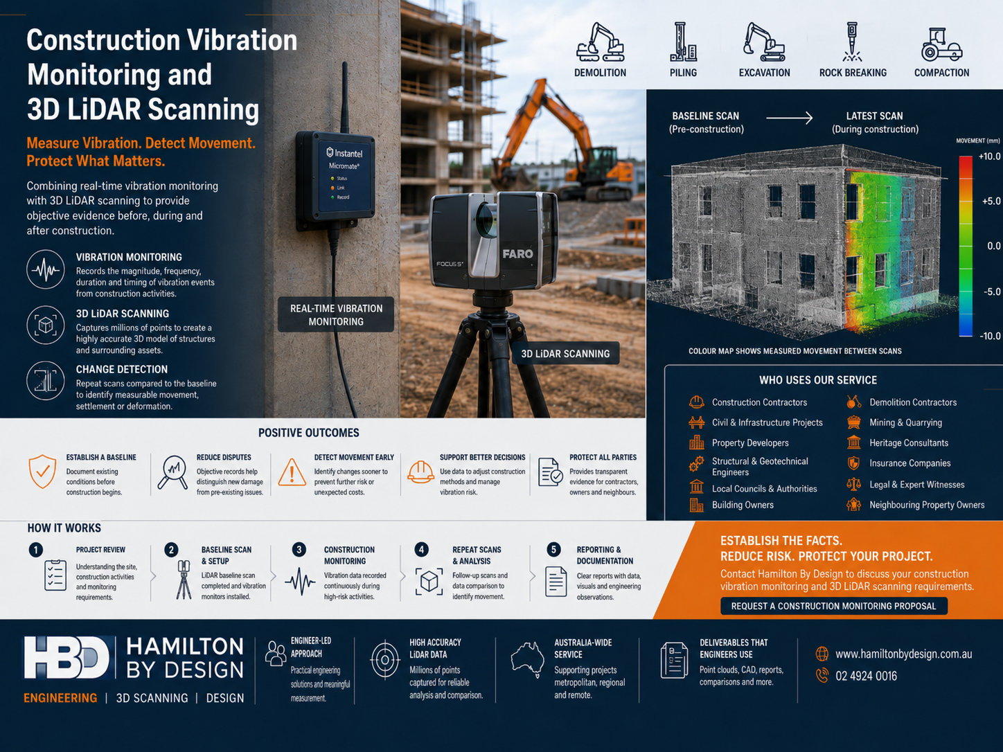
Construction activities such as demolition, excavation, piling, drilling, rock breaking, compaction and heavy-equipment operation can generate vibration that affects nearby buildings, structures, services and infrastructure.
When concerns arise, vibration readings alone may not establish whether a structure has physically moved or changed. Photographs and manual measurements can also make small changes difficult to identify accurately.
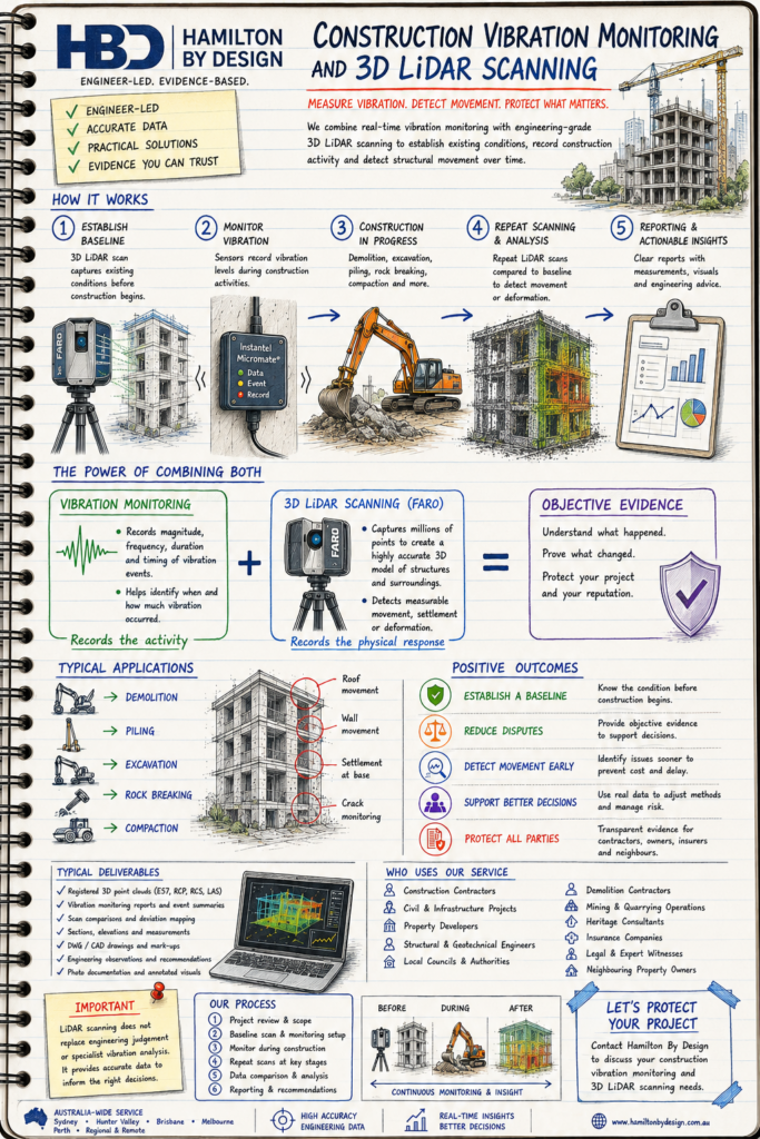
Hamilton By Design combines construction vibration monitoring with engineering-grade 3D LiDAR scanning to establish existing conditions, record vibration events and measure changes in surrounding structures over time.
This integrated approach provides contractors, engineers, developers, asset owners and neighbouring property owners with objective evidence for construction planning, risk management and technical investigations.
Discuss Your Construction Monitoring Requirements
Why Combine Vibration Monitoring with 3D LiDAR Scanning?
Construction vibration monitoring measures the vibration generated by construction activities.
3D LiDAR scanning records the physical geometry and condition of the surrounding environment.
Used together, these technologies help answer two important questions:
- What level of vibration occurred?
- Did the surrounding structure measurably move or change?
A vibration monitor can record the timing, magnitude, frequency and duration of a vibration event. A LiDAR scanner can produce a detailed three-dimensional record of walls, floors, columns, façades, retaining walls, structural frames and surrounding infrastructure.
Repeat scans can then be compared with the original baseline to identify measurable movement, deformation, settlement or changes in alignment.
Vibration monitoring records the construction activity. LiDAR scanning records the physical response of the surrounding structure.
The Construction Risk We Help Address
Construction projects frequently take place close to existing buildings, infrastructure and occupied properties.
Potential risks can include:
- Complaints from neighbouring property owners
- Uncertainty regarding pre-existing cracks or defects
- Structural movement near excavations
- Settlement or deformation of surrounding assets
- Excessive vibration from demolition or piling
- Damage allegations that are difficult to verify
- Disputes between contractors and property owners
- Limited or outdated existing-condition documentation
- Delays caused by unresolved vibration concerns
- Insufficient evidence for insurance or engineering investigations
A structured monitoring program helps establish the facts before concerns become larger technical, commercial or legal problems.
Our Construction Monitoring Services
Pre-Construction 3D LiDAR Baseline Survey
Before construction begins, Hamilton By Design can scan nominated surrounding structures and assets to establish an accurate three-dimensional baseline.
The baseline scan may capture:
- Building façades
- Internal and external walls
- Structural columns and beams
- Floor and slab levels
- Retaining walls
- Roof structures
- Heritage features
- Adjacent infrastructure
- Plant and equipment
- Pipelines and services
- Roads, pavements and hardstands
- Excavation boundaries
- Existing deformation or misalignment
The resulting registered point cloud provides a detailed digital record of existing conditions at the time of scanning.
This baseline can later be compared with follow-up scans to assess whether measurable changes have occurred.
Construction Vibration Monitoring
Vibration-monitoring equipment can be positioned at nominated structures or sensitive locations before high-vibration work begins.
Monitoring may support activities such as:
- Demolition
- Excavation
- Piling
- Rock breaking
- Blasting
- Drilling
- Compaction
- Tunnelling
- Road construction
- Rail works
- Heavy-equipment operation
- Structural modification
- Industrial construction
- Mining and quarrying activities
Depending on the project requirements, monitoring can be completed continuously, periodically or during nominated high-risk construction activities.
The vibration-monitoring program should be developed around the project scope, construction method, nearby assets and project-specific vibration criteria.
Repeat 3D LiDAR Scanning
Repeat LiDAR scans can be completed at nominated stages of construction or following a significant vibration event.
Typical scanning stages may include:
- Before construction begins
- Following demolition
- During excavation
- After piling
- At nominated construction milestones
- Following a threshold exceedance
- After a complaint or reported incident
- At project completion
Comparing registered scans over time can assist in identifying changes in geometry, position, alignment or surface condition.
Structural Movement and Deformation Assessment
Where suitable scan coverage and control are available, point-cloud comparison may identify measurable changes such as:
- Wall movement
- Column displacement
- Floor settlement
- Slab deformation
- Retaining-wall movement
- Structural misalignment
- Changes in level
- Surface deformation
- Deflection of structural elements
- Movement around excavations
- Changes to adjacent plant or infrastructure
Results must be assessed in the context of scan accuracy, site conditions, monitoring controls, environmental factors and the engineering significance of the measured change.
Post-Construction Verification
A final 3D LiDAR scan can be completed after construction to document the condition and geometry of surrounding structures.
The final scan may be compared with the original baseline to support:
- Project close-out
- Handover documentation
- Verification of surrounding assets
- Neighbouring-property reviews
- Engineering investigations
- Insurance assessment
- Dispute resolution
- Long-term asset records
This creates a traceable record covering conditions before, during and after construction.
Who Uses Construction Vibration and LiDAR Monitoring?
Construction Contractors
Construction contractors can use the service to manage vibration risk, verify surrounding conditions and respond to complaints with objective project records.
Civil Contractors
Civil contractors may require monitoring during roadworks, bridge construction, tunnelling, piling, excavation, rail projects and major earthworks.
Property Developers
Developers can establish a reliable record of neighbouring properties and demonstrate that construction risks have been actively managed.
Structural Engineers
Structural engineers can use point-cloud information and vibration records when investigating movement, cracking, settlement or suspected construction damage.
Geotechnical Engineers
Geotechnical engineers may use the information alongside ground-movement, excavation, shoring and foundation-monitoring data.
Demolition Contractors
Demolition contractors can monitor vibration and document adjacent structures before, during and after demolition activities.
Local Councils and Government Authorities
Government agencies can use monitoring records to manage risks to roads, public buildings, heritage assets and community infrastructure.
Building Owners and Facility Managers
Owners and facility managers can establish the condition of their assets before nearby construction, refurbishment or demolition work begins.
Heritage Consultants
Detailed LiDAR records can document sensitive heritage structures, façades and architectural features where small changes may be important.
Mining and Quarrying Operations
Mining and quarrying companies may require vibration monitoring and repeat scanning around blasting, crushing, drilling, excavation and heavy mobile equipment.
Insurance Companies and Loss Assessors
Insurers and loss assessors can use time-stamped monitoring records when reviewing whether reported damage is consistent with construction activities.
Legal Teams and Expert Witnesses
Technical records may support construction disputes, damage claims, engineering investigations and expert reviews.
Neighbouring Property Owners
Property owners may commission an independent baseline survey where major construction or demolition work is planned nearby.
Positive Outcomes
Establish Existing Conditions
A baseline LiDAR scan provides a measurable record of a structure before construction begins.
Reduce Unsupported Claims
Dated scan data and vibration records can help distinguish between pre-existing conditions and changes occurring during construction.
Identify Movement Earlier
Repeat scanning can help detect movement or deformation before it develops into a larger engineering or commercial problem.
Improve Construction Decisions
Monitoring results can support changes to construction methods, equipment, sequencing, exclusion zones and work practices.
Protect Contractors and Property Owners
Objective records provide greater transparency for all parties and reduce reliance on memory, photographs or conflicting observations.
Support Engineering Investigations
Engineers can compare vibration events with measured physical changes when determining whether further assessment is required.
Strengthen Project Governance
A documented monitoring program demonstrates that vibration risks have been identified, measured and actively managed.
Improve Project Close-Out
Final verification provides useful records for handover, asset management and future construction planning.
Reduce Delays and Disputes
Early identification and investigation of concerns can reduce the likelihood of prolonged complaints, claims and project interruptions.
Typical Project Applications
Construction vibration and LiDAR monitoring may be suitable for:
- Excavations beside existing buildings
- Basement construction
- Piling near residential or commercial properties
- Demolition in built-up areas
- Road and bridge construction
- Railway and light-rail projects
- Tunnelling works
- Heritage-building protection
- Construction near hospitals or sensitive facilities
- Rock breaking and controlled blasting
- Mining and quarrying operations
- Industrial plant upgrades
- Brownfield construction
- Retaining-wall construction
- Utility and pipeline projects
- Construction beside operational infrastructure
How the Monitoring Process Works
1. Project Review
We review the construction activities, surrounding structures, nominated monitoring locations and the primary project risks.
Information reviewed may include:
- Construction scope
- Site layout
- Work methodology
- Nearby buildings and infrastructure
- Sensitive assets
- Monitoring duration
- Expected vibration-generating activities
- Existing drawings
- Required reporting
- Project-specific monitoring limits
2. Baseline LiDAR Scanning
Relevant structures and surrounding assets are scanned before high-risk work begins.
The scans are registered to create a coordinated three-dimensional point cloud.
3. Monitoring Locations Established
Vibration-monitoring locations are selected based on construction activity, sensitive structures and engineering requirements.
4. Construction Monitoring
Vibration data is recorded during nominated construction activities.
Where required, monitoring results can be reviewed against agreed project limits or trigger levels.
5. Triggered Inspection or Repeat Scanning
Additional inspections or scans may be completed following:
- A monitoring threshold exceedance
- A reported vibration event
- A neighbouring-property complaint
- Completion of a high-risk construction stage
- Observed movement or cracking
- A nominated project milestone
6. Data Comparison
Repeat LiDAR scans can be aligned and compared with the original baseline.
Areas of potential movement or deformation can be reviewed in three dimensions.
7. Reporting
The final deliverable can combine vibration records, scan information, observations and measured comparisons into a structured project record.
Potential Deliverables
Depending on the project scope, deliverables may include:
- Pre-construction 3D point cloud
- Existing-condition scan record
- Registered point-cloud files
- Vibration-monitoring records
- Event and exceedance summaries
- Monitoring-location plans
- Repeat-scan point clouds
- Scan-to-scan comparison
- Deviation mapping
- Sections and elevations
- Movement or deformation measurements
- Annotated images
- Existing-condition drawings
- Post-construction verification record
- Engineering observation report
- Data for structural or geotechnical review
Common point-cloud formats may include:
- E57
- RCP
- RCS
- LAS
- XYZ
CAD and documentation formats may include:
- DWG
- DXF
- STEP
- SAT
- Parasolid
- Native SolidWorks files, where required
Engineering-Led Reality Capture
Hamilton By Design approaches LiDAR scanning as an engineering measurement tool rather than simply a visual survey.
Our background in mechanical engineering, structural drafting, industrial design, construction verification and existing-condition documentation allows scanning requirements to be considered in relation to the actual project risk.
This means considering:
- What needs to be measured
- Why the measurement is required
- What level of accuracy is practical
- How repeat scans will be aligned
- Which structures are most sensitive
- How the information will be interpreted
- What deliverables the wider engineering team requires
The result is a monitoring program designed to produce usable engineering evidence.
Important Monitoring Considerations
The effectiveness of repeat LiDAR scanning depends on the quality and repeatability of the measurement process.
Important considerations include:
- Stable survey control
- Consistent scan locations
- Adequate scan density
- Clear line of sight
- Surface reflectivity
- Environmental conditions
- Scanner setup and registration
- Monitoring duration
- Appropriate baseline timing
- Access to relevant structures
- Expected magnitude of movement
- Required measurement confidence
- Coordination with structural, geotechnical or vibration specialists
LiDAR scanning does not replace structural engineering judgement, geotechnical assessment or specialist vibration analysis.
Where specialist certification or regulatory monitoring is required, Hamilton By Design can work alongside the project’s structural engineer, geotechnical engineer, acoustic consultant, vibration specialist or survey team.
Why Hamilton By Design?
Engineer-Led Scanning
The scanning scope is developed around the engineering question and intended project outcome.
Detailed Existing-Condition Capture
Millions of measurement points provide a comprehensive digital record of complex structures and construction environments.
Practical Construction Experience
Our experience across industrial, mining, commercial and infrastructure projects supports practical site planning and meaningful deliverables.
Repeatable Digital Records
Registered point clouds provide a consistent basis for comparing conditions at different project stages.
Engineering-Compatible Deliverables
Point clouds, CAD files, sections, elevations and comparison information can be prepared for use by project engineers, designers and contractors.
Australia-Wide Capability
Hamilton By Design supports construction, mining, industrial and infrastructure projects throughout metropolitan, regional and remote Australia.
Independent Evidence
Objective measurement records help establish facts and reduce reliance on assumptions or unsupported observations.
Frequently Asked Questions
What is construction vibration monitoring?
Construction vibration monitoring involves measuring ground or structural vibration generated by activities such as demolition, piling, excavation, drilling, compaction and heavy-equipment operation.
Why is LiDAR scanning useful for vibration monitoring?
Vibration instruments record the vibration event, but they do not directly show whether the surrounding structure has physically moved. LiDAR scanning creates a measurable 3D record that can be compared over time.
Should scanning be completed before construction?
Yes. A pre-construction scan establishes the baseline required for meaningful comparison with later scans.
Can LiDAR scanning detect cracks?
LiDAR can document visible surfaces and broader geometric changes, but it is not always suitable for detecting or measuring fine cracks. Close-range photography, crack gauges or specialist inspections may be required for detailed crack monitoring.
Can repeat scanning measure settlement?
Repeat scans may identify changes in levels or structural position where the expected movement is greater than the combined measurement uncertainty and appropriate control has been established.
Does LiDAR replace a dilapidation report?
LiDAR can significantly strengthen an existing-condition or dilapidation assessment, but the appropriate scope depends on project requirements. A complete assessment may also include photographs, written observations and specialist inspections.
Can the service be used after a vibration complaint?
Yes. Existing-condition scanning, repeat scanning and monitoring records can support an investigation. However, the strength of the comparison is greater where a reliable pre-construction baseline exists.
Can you monitor heritage buildings?
Yes. LiDAR scanning is well suited to documenting complex façades, architectural features and structural geometry. The monitoring methodology should be developed with the heritage and structural project teams.
Can vibration alerts be provided?
Depending on the selected monitoring equipment and project requirements, alerts may be configured around nominated trigger levels. Alert arrangements should be confirmed during project planning.
Can you work with our structural or geotechnical engineer?
Yes. Hamilton By Design can provide point-cloud data, measured comparisons and engineering documentation for review by the project’s structural, geotechnical, civil or vibration specialists.
Construction Vibration Monitoring and LiDAR Scanning Across Australia
Hamilton By Design provides engineering-grade 3D LiDAR scanning and construction measurement support across Australia, including:
- Sydney
- Central Coast
- Newcastle
- Hunter Valley
- Wollongong
- Canberra
- Brisbane
- Melbourne
- Adelaide
- Perth
- Darwin
- Mount Isa
- Regional and remote industrial locations
Travel and site requirements can be assessed as part of the project proposal.
Establish the Facts Before Construction Begins
Construction vibration concerns are easier to investigate when reliable baseline information has already been captured.
Combining vibration monitoring with engineering-grade 3D LiDAR scanning provides a more complete record of construction activity and surrounding structural conditions.
Whether your project involves demolition, excavation, piling, civil construction, industrial upgrades or sensitive neighbouring assets, Hamilton By Design can develop a practical monitoring and reality-capture scope suited to the project.
Discuss Your Project
Contact Hamilton By Design to discuss:
- The proposed construction activity
- Nearby buildings or infrastructure
- Sensitive or heritage assets
- Required monitoring duration
- Baseline scanning requirements
- Construction milestones
- Reporting requirements
- Point-cloud and CAD deliverables
Request a Construction Monitoring Proposal
Hamilton By Design Co.
Mechanical Engineering | 3D LiDAR Scanning | 3D Modelling

Contact Us – Talk To Us
Our clients:
























